
The VQ-820-G proves benefit of airborne lidar with Sandy River demo
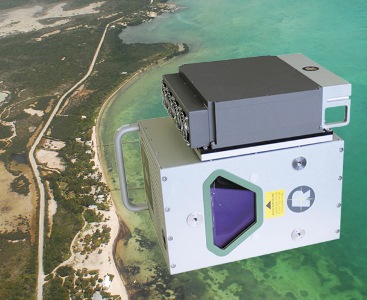
The world’s first “tightly coupled,” shallow-water, land and smart echo waveform lidar sensor, the RIEGL VQ-820-G, won the Geospatial World Award for innovation in surveying at the Geospatial World Forum Conference this week in Rotterdam.
RIEGL Laser Measurement Systems GmbH, headquartered in Horn, Austria, manufactures terrestrial (static), mobile (kinematic), airborne and industrial laser scanning hardware with proprietary software packages for data acquisition and processing for multiple fields of applications.
The topo-hydrographic scanner demonstrated the possibilities of data capture for mapping channel and floodplain morphology during several live demonstrations in the last few months.
One such data collection demonstration took place over Oregon’s Sandy River, where rough waters make it challenging for traditional transect or boat-based hydrographic surveys.
RIEGL said its software suite was a key element in the demionstration’s success due to its ability to calibrate, acquire, process, georeference and export data.
“We are proud to receive this prestigious award and feel acknowledged to further intensifying our research & development efforts for this exciting field of combined topographic and hydrographic airborne laser scanning,” said Martin Pfennigbauer, RIEGL’s director of research and product manager for bathymetric sensors, who was presented the award during award night at the event.


