Written By: European Association of Aerial Surveying Industries
Across the world, electricity distribution networks face a persistent challenge: vegetation encroachment. Trees growing too close to power lines, or falling onto them during storms, are a major cause of outages. Managing this risk across large territories requires both precision and scale.
This is where crewed airborne surveying can add value. By combining LiDAR acquisition with automated analytics, aerial platforms can map extensive infrastructure networks quickly and in high detail, helping utilities identify risk areas and support more proactive vegetation management.
A recent project in Canada illustrates how this can be achieved in practice.
The Challenge: Managing Vegetation Across 103,000 km of Power Lines
A major electricity utility in Eastern Canada, through its distribution division, is responsible for managing an extensive electricity network with more than 103,000 kilometres of distribution lines, the scale of operations is considerable.
Vegetation is the primary source of disruption. Trees encroaching on clearance zones or falling onto conductors account for the majority of power outages. In response, the utility has set an ambitious objective: to reduce outages by 50% by 2028.
Achieving this goal requires a fundamental shift. Traditional inspection methods, often based on ground surveys or manual interpretation, are not sufficient at this scale. The utility needed a solution capable of:
· Detecting vegetation encroachment automatically
· Identifying hazardous trees beyond immediate clearance zones
· Operating efficiently across large and diverse territories
· Delivering consistent, high-quality data for operational planning
The Solution: Integrating Airborne LiDAR and AI
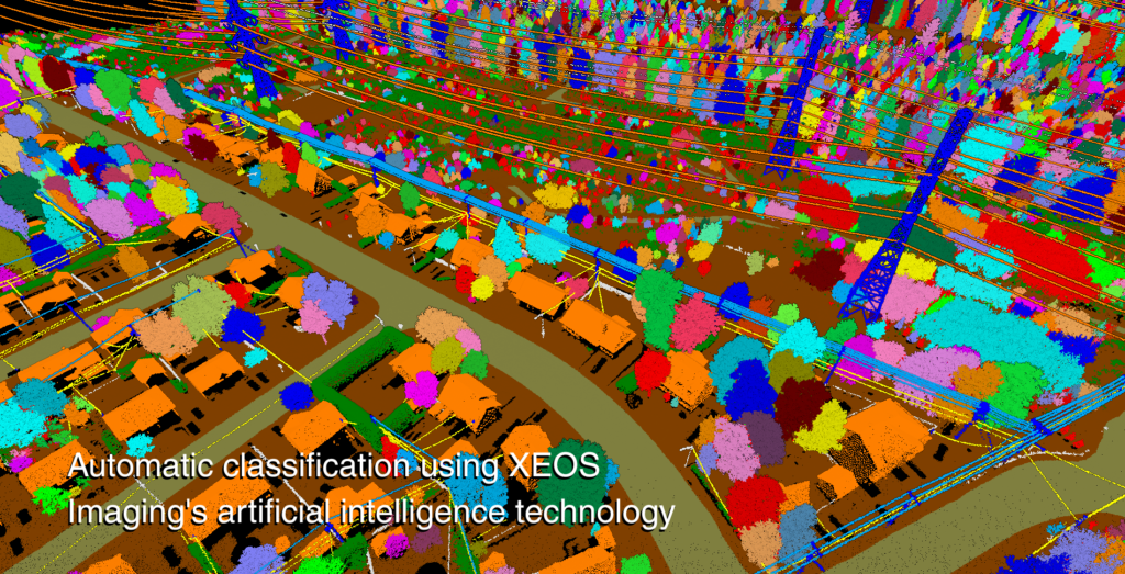
To address this challenge, XEOS Imaging developed a methodology combining airborne LiDAR acquisition with proprietary artificial intelligence tools. The project focused on targeted sections of the network. At the core of the solution is a crewed airborne platform. Using a Piper Navajo aircraft, XEOS Imaging conducted LiDAR acquisition campaigns optimized for detecting fine linear features such as distribution power lines. Flying at approximately 180 knots, the platform achieves a balance between coverage efficiency and operational cost, a key advantage over slower or more limited systems. The LiDAR system used for this project is the RIEGL VQ-1460, a high-performance sensor designed to capture dense and accurate point cloud data. The acquisition parameters were carefully configured to ensure reliable detection of thin conductors, regardless of their orientation.
Timing also plays a critical role. Data acquisition was carried out during leaf-off conditions, significantly improving visibility through the canopy and enhancing the detection of both power lines and surrounding vegetation.
Once acquired, the data is processed using XEOS Imaging’s AI-driven workflows. These tools automatically classify the point cloud, identifying:
· Distribution poles and medium-voltage lines
· Vegetation within clearance zones
· Hazardous trees within a 30-metre buffer on each side of the network
Without automation, processing datasets of this size and complexity would require extensive manual effort. AI enables both speed and consistency, transforming raw data into actionable information at scale. Both XEOS Imaging and RIEGL are members of the European Association of Aerial Surveying Industries (EAASI), reflecting the strong expertise within the association across both data acquisition and sensor technology.
The Results: From Data to Actionable Insights
During the winter of 2025–2026, the system was deployed across 11 municipalities, translating advanced airborne data acquisition and AI-driven processing into tangible operational outputs. The project delivered a detailed three-dimensional representation of the electricity distribution network, capturing poles and medium-voltage lines with a level of precision that supports both analysis and intervention planning.
Beyond infrastructure mapping, the real value lies in the identification of risk. The datasets reveal where vegetation is already encroaching into clearance zones, as well as where trees located within a 30-metre buffer could pose a fall-in hazard. This dual perspective allows the utility to move from a reactive model to a predictive one, where potential disruptions can be identified and addressed before they translate into outages.
In practical terms, this means that vegetation management is no longer guided by periodic inspections or generalized assumptions, but by precise, location-specific intelligence. Maintenance teams can prioritise interventions, optimise field operations and allocate resources where they are most needed.
While the long-term impact will be measured over the coming years, the direction is clear. By integrating high-resolution airborne data with automated analysis, the utility is building a more proactive and resilient approach to network management, one that directly supports its objective of reducing power outages.
Why Crewed Airborne Surveying Matters
This use case highlights several reasons why crewed airborne systems remain essential in modern geospatial workflows.
1. Efficiency at Scale
Covering tens of thousands of kilometres of infrastructure requires platforms capable of sustained, high-speed acquisition. Crewed aircraft provide the endurance and range needed to map large territories within tight timeframes.
2. Sensor Capability
Advanced LiDAR systems, such as the RIEGL VQ-1460, can be integrated into crewed platforms to deliver high-density, high-accuracy data. These systems are particularly well-suited for detecting small, complex features like power lines.
3. Operational Flexibility
Flight parameters can be optimized for specific project requirements, from altitude and speed to acquisition angles and timing. This flexibility ensures that data quality meets the needs of demanding applications.
4. Integration with Advanced Analytics
The combination of airborne data acquisition and AI-driven processing creates a powerful workflow. Data is not only captured efficiently but also transformed into insights that can directly support decision-making.
A Model for Infrastructure Resilience
As infrastructure networks become more complex and climate-related risks increase, the need for reliable, scalable monitoring solutions continues to grow.
The collaboration between XEOS Imaging and RIEGL demonstrates how this can be achieved: by combining expertise in airborne data acquisition, sensor technology, and advanced analytics.
More broadly, it illustrates the evolving role of the geospatial sector. The value no longer lies solely in data collection, but in the ability to deliver integrated solutions that support real-world outcomes — in this case, a more resilient and reliable power distribution network.
Crewed airborne surveying, far from being a legacy approach, remains a critical component of this transformation. It provides the foundation on which advanced analytics, automation, and infrastructure intelligence are built.
As utilities and public authorities seek to modernize their operations, such approaches are likely to become increasingly central — not only in Eastern Canada, but across Europe and beyond.