Buy brings additional equipment, 20 employees, Midwest office
LEXINGTON, Ky. – Citing increased demand in the marketplace and a good organizational fit, geospatial services provider Photo Science announced this week the acquisition of MJ Harden from GeoEye. Terms were not released, but Photo Science senior VP of business development Bob Hickey said the deal brought not only extra lidar and photographic equipment, but also an office in Mission, Kan., and roughly 20 employees.
“For the past three or four years part of our plan has been focused on increasing our aerial assets,” Hickey said, “as well our geographic reach.” With headquarters here, along with offices in Philadelphia, Maryland, Atlanta, Florida, Michigan, Colorado Springs, and San Francisco, the Harden buy gives Photo Science its first real physical presence in the center of the United States. Plus, Hickey said, Photo Science and MJ Harden had a working relationship where each had sub-contracted to the other at one point or another.
“They were a known entity,” Hickey said, “and we really lacked capability in the middle of the country.” There was also a lot of technical synergy, he said, as Harden brings two Z/I DMC cameras and an Optech lidar sensor with which Photo Science is already familiar, bringing their total inventory to six large-format digital framing cameras that include both the Z/I DMC and Vexcel UtlraCam sensors and eight lidar sensors, including four Optech Geminis, two Leica ALS-70s, and two Leica ALS-50II models.
“We’ve really complemented our existing capabilities,” Hickey said, “so from a workflow and production standpoint it makes the integration much smoother.”
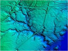
It wasn’t just geographic reach and technology that fueled the acquisition, though. Photo Science is also seeing increased demand for their services across the country, Hickey said. “Last year, probably going back two years, imagery was kind of king, but over the last 12 to 24 months there’s been an increased demand for lidar – topo-developed databases using lidar technology,” he said. “We have seen an increase, and that’s why we’ve been steadily increasing that capability.”
Photo Science purchased three Optech Gemini lidar sensors in November 2009, then purchased HJW GeoSpatial in July of 2010, giving them their first west coast office and increasing capacity to 10 aircraft at the time. They report having gathered more than 400,000 square miles of lidar in the last five years. In May of this year Photo Science announced an agreement with RapidEye, giving them the ability to resell satellite imagery.
What’s driving the increased demand for lidar, specifically? First there is just the maturation of the technology and market, Hickey said. “As a technology, it’s more generally accepted now as a methodology for getting very accurate topography,” he said, “but, beyond that, going back six or seven years, the technology was really just used for digital elevation models, and I don’t think the end users really appreciated some of the other data sets that can be derived from it – like vegetation analysis, just to name one … It’s now going beyond what people were traditionally using the data set for.”
That education of the marketplace and maturation of the technology comes with an increased performance demand, too, though, he said.
Once end users know what’s possible, they want it all. “We’re seeing point-spacing requirements that really exceed what’s necessary,” he said. “They’re going from 1.5 points per square meter to eight points per square meter,” and that means larger datasets that are more difficult to process, store, and move around. “We’re always learning new tricks,” Hickey chuckled.
Moving forward, Photo Science is starting to look at integration of data from its terrestrial mobile scanning vehicle – an Optech Lynx system – and the aerial lidar data. DoTs, for example, are starting to request very accurate roadway data and then are interested in how that integrates with airborne data that might have been collected at the county or state level as they move into general planning mode. “We’re definitely seeing that happening and we see that as growth potential for us,” Hickey said.