

The enterprise world, thinking about industries like construction, energy and utilities, as well as factory and warehouse businesses, has been embracing technology in recent years like they never had before. A sector that has long held the reputation, fairly or unfairly, of being laggards in the tech space, they’ve embraced new tools in recent years, with one such example being uncrewed vehicles. While inspections on a job site are an important part of the process and can prevent major delays or budget overtures, they can also be fairly tedious and time-consuming. By turning to uncrewed vehicles like drones and robots, more humans can be opened up for time to complete other parts of the project, which is particularly important in this era of worker shortages. Being able to rely on this technology can ensure projects continue to proceed on time and within budget.
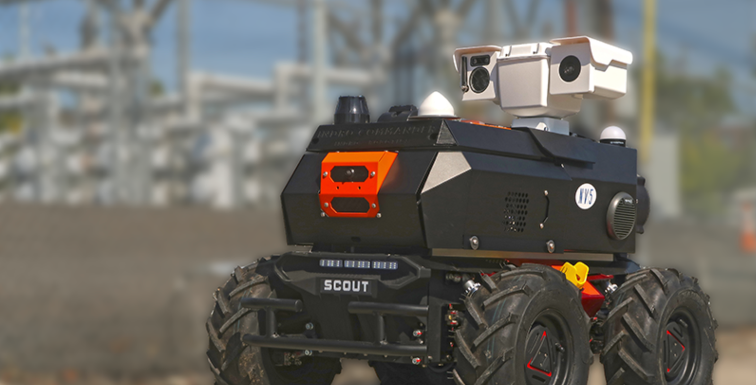
There are plenty of companies who are offering these kinds of tools to worksites, with NV5 Geospatial being one of the top names to provide key geospatial data to their customers through the use of uncrewed vehicles. Last month, the company announced their latest solution in this space, the ARIS II Rover. The remotely-controlled rover is equipped with advanced imaging technology which, per the company, can “help safely and accurately diagnose a multitude of problems in a substation on a regular basis.”
The new substation is the product of a long lead time from NV5 Geospatial, who notes that the ARIS II Rover is the product of five years of in-field implementation and testing. The robotic system was developed to be used in just about any environment, with the ability to continue functioning in hard environmental conditions and over a variety of terrains that are commonly found at distribution and transmission substations. The rover is also customizable with a modular design, supporting thermal sensors, imagine, and audio/video technology, carrying a payload capacity up to 110 pounds. It provides up to six hours of battery life or two miles of driving, and comes with a recharge garage.
It’s not hard to imagine a wide variety of use cases for this new rover, particularly given the ability to shift focus with different payloads. The thermal imaging provides the ability to catch potential maintenance issues before a human may be able to identify them as frequent thermal scans completed by the rover can detect temperature changes that could lead to significant problems. Along those same maintenance lines, NV5 Geospatial also calls out the ARIS II’s ability to read gauges from up to 50 feet away, allowing for frequent checks to improve revenue accurate and create fault analysis reports. The rover can also be equipped to perform 3D lidar scans which can be used to create digital twins of assets to enhance understanding of a site, and can even be used for security surveillance purposes after workers have left a site for the day.
The ARIS II is just one of the offerings from NV5 Geospatial, who has long been one of the top firms offering geospatial data and analytics to maximize insights gained from the data collected. The Florida-based company offers a variety of geospatial data solutions, working with all kinds of infrastructure entities, ranging from electric utilities to airports to forestry, and plenty in addition to that. The company provides four different types of geospatial data – lidar, topobathy lidar, orthoimagery, and hyperspectral – and the tools to collect this data via aircraft, seacraft, the aforementioned robotic rovers, mobile systems, and drones.
The ARIS II Rover is just the latest offering from NV5 Geospatial to provide key data to its customers. On the new tool, NV5 Geospatial Vice President of Innovation Ian Birdie said, “Geographic and personnel limitations, combined with aging infrastructure, present significant challenges for utility companies when it comes to maintaining their substations. With our extensive experience in these substation environments, NV5 Geospatial has customized the ARIS II Rover for the unique needs of utilities.” He’d add, “On-time information allows quick response to equipment anomalies, weather events, and intrusions before they have an impact.”


