

Earlier this month in Las Vegas, the Commercial UAV Expo displayed just how much the uncrewed vehicle market has grown in recent years, with a huge number of growing industries taking advantage of drone technology. One of the spaces most heavily represented, and among the earlier adopters in the commercial UAV world, is surveying and mapping. Particularly when these tools are enabled with lidar sensors, there is a tremendous amount of value to be added for surveyors willing to take the leap. On the other hand, there are still some limitations and barriers that need to be overcome, most notably with solutions for larger areas.
In a space of constant innovation, it’s expected that companies are always looking to close these gaps as best as they can. With that in mind, a recent announcement was released earlier this month trying to tackle the issue of long-range aerial lidar surveying, with TOPODRONE and Velodyne announcing the synchronization of the former’s LiDAR PRIME scanner and the aOrion Heli-E UAV, enabled by Velodyne’s Alpha Prime sensor. The companies’ press release boasts that “this new mapping solution fills the gap between heavyweight and expensive manned aerial lidar systems, and lightweight drone systems.”
The big sell these companies are making with this most recent chapter in their partnership is the increased ability to perform high-accuracy surveys for large areas. Previously, these kinds of projects were only able to be completed using manned airplanes or helicopters. By introducing the capability for a greater number of potential projects. Whether because of expenses, safety, or other reasons, there are certain terrains and areas that are not easily surveyed by manned aerial vehicles, making the ability for drones to cover more of these space accurately a potentially major breakthrough for the industry.
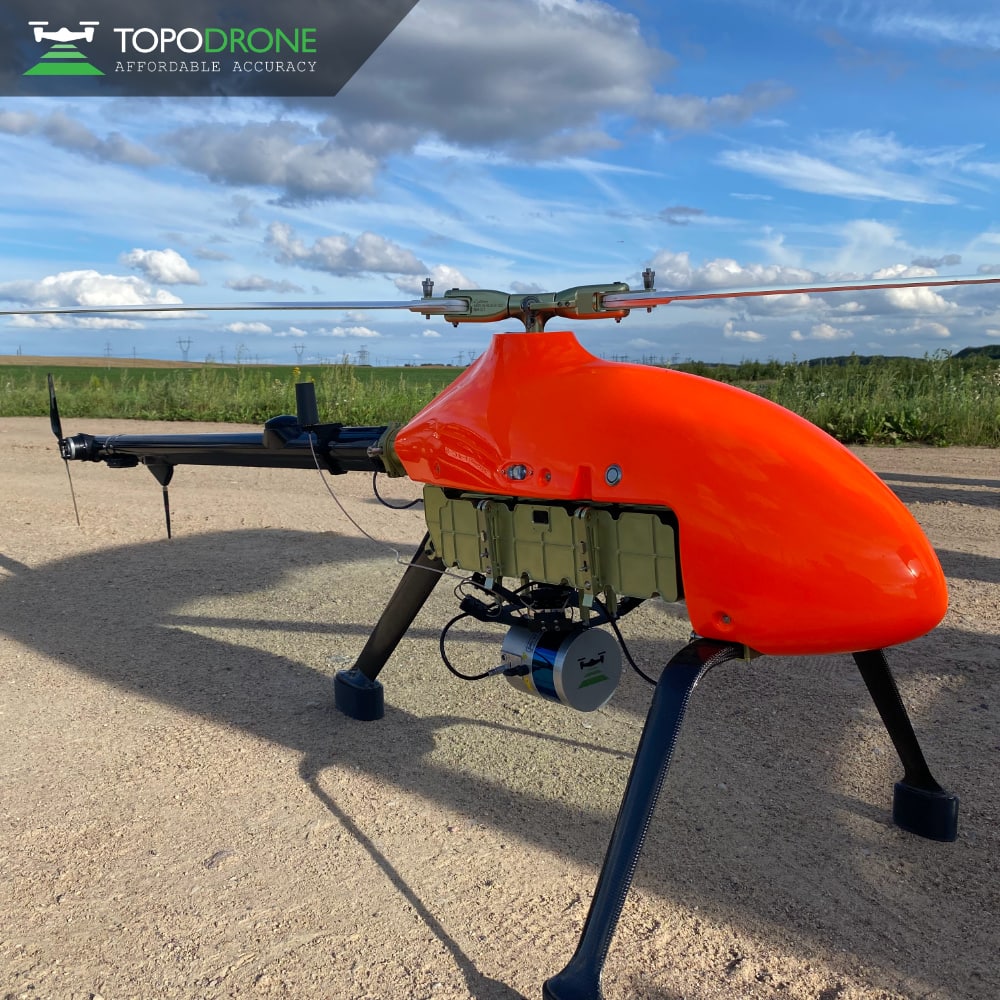
TOPODRONE is based in Switzerland and is a manufacturer of high-precision lidar equipment designed to be installed on drones, vehicles, and/or backpacks. The company generally works with the surveying and mapping industry to create 3D models, as well as with forestry and agriculture. They also provide post-processing software to give users an end-to-end solution for their drone surveying. LiDAR PRIME is the company’s most advanced lidar system, with a working range up to 300 meters covering a 500-meter corridor width and more than 20 square kilometers per flight.
The LiDAR Prime is equipped with a sensor from Velodyne, the Alpha Prime. The sensor comes with an accuracy of three to five centimeters, and includes a built-in GNSS receiver as well as an integrated Inertial Navigation Unit (IMU). Velodyne, a U.S.-based company in San Jose, partners with a number of different companies and industries who can utilize their sensors. That includes places like Boston Dynamics, who have integrated Velodyne sensors with their famous Spot robot, as well as autonomous vehicle companies.
This solution developed by TOPODRONE and Velodyne will be integrated with the Heli-E drone, manufactured by aOrion. The Heli-E is a long-range drone that is fully electric and autonomous, able to carry a payload of up to seven kilograms with a maximum flight time of 105 minutes. The modular system is a fully redundant drone designed without a single-point-of-failure, and requires only one operator to conduct a mission with only a five-minute assembly time. It can also function in a wide variety of weather conditions, furthering the advantage discussed above compared to operations able to be completed by manned aircraft. The Heli-E can perform with wind speeds up to 15 meters per second (about 33 mph), with temperatures ranging from -30 to +45 Celsius (-22 to 113 Fahrenheit), and a millimeter per hour of precipitation.
While surveying and mapping is among the earliest adopters of drone technology, it’s still clear that developments are continuing to come across. This latest integration to ensure large areas can be scanned with lidar-enabled drones is one of those big steps. TOPODRONE CEO Maxim Baklykov said of this latest development, “‘The system provides users the opportunity to capture tens of kilometers of power lines, dozens or even hundreds of square kilometers of a surveying area when a manual inspection, piloted helicopter or a multicopter bring too much risk, high expenses, or can not meet the challenge.”


