

One of the most apparent results of climate change has been a steady uptick in extreme weather events, or natural disasters, all around the world. These trends have been seen in all corners of the globe and relating to just about every type of natural disaster that one can think of. In the United States alone, according to a study from NOAA, there were 28 “weather and climate disasters” across the nation in 2023, surpassing a previous record of 22 recorded in 2020. The disasters in total cost communities around the nation nearly $93 billion, and that’s not including a late-year storm and flooding event that affected most of the East Coast.
Of course, financial effects are just one aspect of disasters, and the human toll is a far more important consideration. All of this has resulted in more attention than ever being paid by governments into ways they can better address the aftermath of these situations and ensure their citizens are as safe as possible. There are many tools that can be utilized by the public sector for these purposes, with geospatial technologies in particular being a key piece to both preparation and response.
The forms these technologies and data take can vary, ranging from satellite to terrestrial, and everything in between, but aerial imagery in particular can provide crucial insights for responders immediately after an extreme weather event. Recently, Geo Week News spoke with Nearmap’s Shelly Carroll about the way governments are utilizing aerial imagery from the company, and how they believe it is a crucial piece for the public sector to keep up with our changing world.
Carroll comes to this work from a place of experience, having spent her career working with, or as a part of, the public sector since getting out of college, specifically around disaster response. She’s noticed in that time the same trends we all have around increasing frequency of these events, and Nearmap is as well.
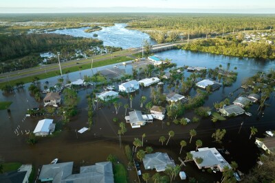
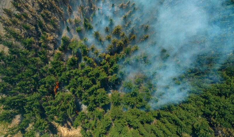
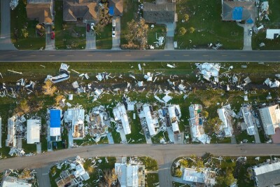
“We look at every year, the increasing number of wildfires, flood events, straight line winds and tornado events,” Carroll said. “It seems as though what used to be very seasonal is becoming year-round. Then you throw in climate change, rising sea levels, all those things are coming together to have more of an impact, and really amplify the types of weather events that we were seeing anyway.”
For Nearmap’s part, the company provides aerial imagery in four countries around the world – the United States, Canada, Australia, and New Zealand – and according to Carroll largely serve customers in three buckets – insurance, government, and commercial. (For clarification, “commercial” generally refers to customers using mapping platforms for consumer-facing applications or for managing their facilities.)
As one would expect, the different sectors use Nearmap’s imagery and other offerings differently, with Carroll explaining some of the key differences with government clients, particularly around this disaster response. For one thing, they generally use a different product than their insurance clients, with the latter utilizing more AI-powered solutions than their government counterparts.
Carroll provides some explanation on that front, which fall into two buckets. One is that governments are generally trying to find solutions that fit into their already-existing systems, which typically requires a more lightweight solution. “One thing people ask about is, How easy is it to consume or ingest your data? We have a government system that we built in-house 20 years ago – can we use Nearmap? We really shine on that integration side of things. We don’t need to replace anyone’s software or systems that they’re already using. We know in government especially, it’s tricky to get all those systems knit together.”
Additionally, post-disaster situations in particular can make it tricky to use high-powered solutions, even including building their own algorithms on top of data provided by Nearmap. “When you get down to the nuts and bolts of things,” Carroll said, “the cell towers may be gone, or power may be running on a generator. There may be eight laptops plugged into a six-outlet power cord. Those types of realities with logistics, I think put a damper on some of the fancier ways to figure out what has happened.”
As a result, Carroll says that Nearmap’s government clients – which range from hyper-local city governments all the way up to federal agencies like FEMA – mostly rely on imagery coming from Nearmap, but that imagery plays a major role thanks to the speed at which it’s able to come in. She explains that this is the major separating factor between the company and its competitors, as they rely on in-house meteorologists to position their data collectors in such a way to ensure quick collection of data after a disaster.
“We are assessing days in advance for where we think the largest risk for those types of events might occur, and we’re pre-positioning our resources to be ready to get in the air as quickly as possible,” Carroll said.
That speed is then combined with the high-frequency of their normal capture cadence – Nearmap generally covers the “populated areas” in the US with two or three flights per year – to give a baseline for change detection, providing insight into the true damage a disaster has inflicted, and the areas most affected.
Generally speaking, governments receive processed imagery from data “usually within a day or two,” according to Carroll. Exact timing is, of course, dependent on the nature of a weather event, but as soon as skies are cleared for flying Nearmap has a pilot out, and officials are given email notifications of the entire process, from when Nearmap starts watching for a potential disaster and every step along the way to when the data has been published and available for use.
One of the big themes in imagery in recent years, though, has been more readily available satellite imagery, so it was natural to wonder what Nearmap says to potential clients who may want to turn to those data sources. Carroll mentions a few differentiating factors with aerial imagery. First is simply resolution. The planes are closer to the scene and can capture the damage in higher resolution, which is important for these workflows as it’s not as easy to create 3D scenes, or to run analysis. Additionally, she says that Nearmap has data going back 10 years at this point, with historical imagery available to customers, which can add more crucial context to change detection.
The reality of the situation, not just in the United States but really across the entire planet, is that governments need to find strategies to both react to the growing number of natural disasters and also prepare for these inevitabilities. Geospatial data, including the kind of aerial imagery captured by Nearmap, fits right into that realm.
As Carroll told Geo Week News, “We can do magic with geospatial data.”


