
Laser scanning has so many cool applications. We recently heard of a project funded by the National Science Foundation to establish a Deep Underground Science and Engineering Lab (DUSEL) in the former Homestake gold mine in Lead, South Dakota, USA, one of the early enterprises associated with the Gold Rush of 1876. Laser scanning anchors the design phase.
With eight million points of the mine collected with a Z+F 5006i Imager, photographs from 1960 and scan modeling using Maptek I-SiTE Studio, Homestake’s DUSEL, when constructed in 2012, will support the underground research needs of major scientific studies in particle and nuclear physics, geology, hydrology, geo-engineering, biology and biochemistry. The dedicated access and diverse geology at Homestake (the deepest mine in North America with rooms at 8,000 feet) are said to be well-suited for studies at extreme depth.
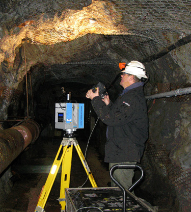
According to Maptek, the firm contracted by RESPEC Engineering to collect data in support of the preliminary design and planning of the laboratory, the drifts were mined in 1920 and no geological mapping was available for the detailed modelling necessary. So, into the narrow confines went Maptek I-Site Technical Services Manager Scott Schiele with the scanner and an M-cam camera. In two days, Schiele scanned two drifts at the 300-foot level from 70 setups for the 1,400 foot of interest and captured 28 photographs at each location.
Understandably, some challenges arose in the drifts including those related to backsighting and registration, appropriate lighting for photography, and later, managing the massive volume of data captured. Fortunately, the Z&F scanner used for the first time by Schiele and his coworkers captured data quickly and effectively for the required needs of the project–eight million points in one minute four seconds, a 40 MB file of medium resolution. The 28 images taken post-scan took about five minutes. The lighting complications in the tight confines, however, stole most of Schiele’s time in the mine, requiring him to change up lighting options to avoid yellow tints and shadowing.
The scans and photographs were imported into I-Site Studio and registered into the coordinate system. Scans were cut into 100-foot sections, and the 28 photographs for each scan were used to map the color data onto the scan; one 360-degree photograph was produced for use when importing the data into I-Site Studio. To register, techs manually rotated scans around the origin of the scanner and applied global registration. Scans were then automatically rotated to a more accurate position using I-Site Studio’s “Matching Features” option, which picks common features in scans with overlapping data. Once the data was in the correct coordinate system, unnecessary objects–scanner, pipes, the wagon of lighting options–and people were filtered out. Scans of the drifts were cut in half down the centerline, making it easier to remove unwanted points from the middle of each section to better view the geology. Processing took about a week and a half, according to Schiele.
The eight million points were reduced to 150,000 for the modeling process. Triangulations were merged and fused with the 100-foot sections to create one continuous surface.
The photographs were rendered onto this surface, matching the points from the scans to the imagery. The model was then imported into Maptek Vulcan 3D mine planning and modeling software, which combined the 3D photo-rendered model, old geology maps, drillholes and other geological data into one environment for advanced geotechnical analysis. “That’s the power of Vulcan,” Schiele said. “It takes all the geology data and brings it into one platform to analysis fault zones, etcetera. The laser scanning brings a whole new level of accuracy the geologists have never known before.”
The 64-bit processing power of I-Site Studio could handle the massive data sets from the project, but some enhancement tools were applied to combine the lower resolution scan data with the high resolution photographic imagery. This new software option allows for a more manageable file size while retaining the high resolution data for detailed analysis of specific areas of interest. This streamlined the file load and zoom functions without losing any detail for in-depth geological analysis in Vulcan later. This option will now be offered to future users of the software.
Dr. Zbigniew (Ziggy) J. Hladysz, of the South Dakota School of Mines, which is involved in site inspections and creation of 3D structural models, said he anticipates Maptek services to be needed throughout the preliminary and final design phases of the project, as well as during construction. Schiele said the company is already planning to do more at the site before the end of the year. The client recently decided to add a couple of levels in other drifts to the overall project scope, including adding the main lab at the 4,850 level.


