

In the general tech world today, you would be hard-pressed to go very long without hearing something about the metaverse. We’ve talked about it here, with regards to the geospatial industry’s place in developing whatever the metaverse ends up being, and broadly speaking Meta’s – formerly known as Facebook – jump into the space has driven a lot of the exponential growth in the space, with a lot of that focus around social aspects. The idea has been in place for years, though, and there are a lot of different angles at which people are coming at this. It includes that social aspect, but also a bevy of industrial and enterprise use cases. It also can take place in made-up, virtual worlds, but also representations of our real, physical world.
For that latter portion, we are seeing plenty of companies jumping into that space with accurate 3D modeling and digital twins to be utilized in the metaverse. One such company is Nextech AR, who focused on augmented reality in part with their ARway platform. They just made some news with regards to these efforts to map the real world, announcing in August that they will be adopting lidar technology to create their meshes for their mapping software. They are making the shift away from video to point cloud technology, citing the ability of lidar to create a much more dense point cloud.
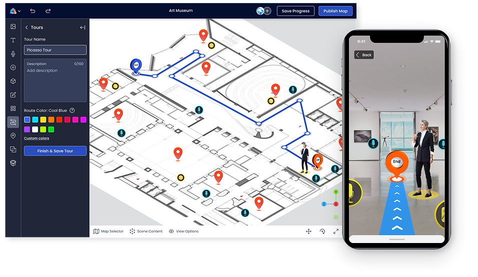
ARway brands itself as an all-in-one metaverse creation toolkit, in which users can spatially map their physical surroundings and then add on interactive 3D elements that can be experienced in AR. There are a number of different elements that can be added onto the map, which can now be created with the aforementioned lidar implementation, including text, audio, images, floorplans, and navigation points. Plenty of use cases have and will be discovered for this type of technology, but one that sticks out is in the retail space.
A store could use the new lidar implementation to create a hyper-accurate model of their location, and then add in navigation tips, floorplans, and messages in both text and audio format. That could all be uploaded into the map, which can then be used by customers using the AR function of the platform on a smartphone or other device to overlay the digital add-ons over the physical world. In addition to the retail space, ARway also calls out stadiums and concert venues as another space that can benefit from this mapping technology that mixes the physical and virtual worlds, as well as trade shows, museums, universities, and hospitals.
The addition of lidar being used to create the the 3D digital twin for these applications should only enhance the utility for these sectors as well. Compared to the previous method of creating the point cloud. ARway expects improved accuracy and occlusion. In their release, they call out one example with regards to the real estate industry, with realtors having a much greater spatial awareness when using lidar to scan a room compared to previous methods.
Nextech AR Solutions, a Canadian-based company headquartered in Toronto, was founded in 2018 and is a 3D commerce and metaverse solution for businesses. They have partnerships with some large retail names already, including Kohl’s and NAPA. In addition to their ARway platform, they also offer ARitize, which turns 3D product images into interactive 3D models, adds 3D models into a model of a space for decorating purposes, and can turn CAD files into 3D models.
On the implementation of lidar into the ARway creation workflow, Nextech CEO Evan Gappelberg had this to say.
“We are constantly analyzing new technologies which can give us a competitive edge in the market and with our adoption of LiDAR which is bleeding edge technology we believe we have gained that edge. Apple Computer has already invested billions into developing LiDAR which is now available in some of the newer iPhones… LiDAR essentially acts as a computer’s eyes. LiDAR has already found a perfect market fit in the automotive industry with all the new EV self-driving cars produced by Tesla and others adopting LiDAR technology. If you’ve ever seen an autonomous vehicle, you may have noticed a rapidly-spinning tube mounted on its roof. This is a LiDAR unit. Its role is to measure the distance of objects relative to the position of the car in 3-D. We believe it’s also a perfect product market fit for AR wayfinding and that adopting LiDAR technology for our ARway solution will give users hyper-accurate spatial maps and provide deep analytics within the map, which is exactly what our customers are telling us they want.”


