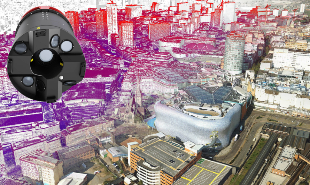
Aerial survey and geographic data company Bluesky International produces and maintains seamless digital aerial photography and height data on a national scale in both Great Britain and the Republic of Ireland. The company already operates a range of aircraft and sensors, including three large format aerial survey cameras, one upgraded CityMapper-1 and a further LiDAR sensor which is mounted with a thermal sensor and survey grade camera, which means Bluesky can offer customers unique and cost-effective geospatial solutions.
The recent decision to purchase a second sensor from Leica was made to support Bluesky’s ambitious growth plans in two main areas. First, the CityMapper-2 will support an increase in commissioned LiDAR capture, says Rachel Tidmarsh, Managing Director of Bluesky International:
“Users requiring specific areas and bespoke specifications often need a quick turnaround and by adding to our capacity we can address this.”
The second area of growth will be to expand and build on the initial success of Bluesky’s MetroVista product range, she adds:
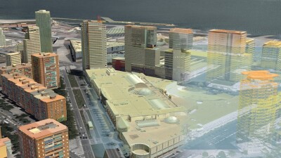
“MetroVista combines ultra-high resolution aerial imagery, both oblique and vertical, together with simultaneously captured LiDAR which addresses an increasing demand for detailed and accurate 3D city information. Applications such as event planning, disaster modeling, insurance risk assessment, mapping for autonomous vehicles as well as the day-to-day delivery and management of frontline services have all contributed to a growing demand for integrated 3D data.”

Covering greater areas during any given flight
The additional data collection capacity of the CityMapper-2 means that Bluesky can do more with the same resources: being able to fly higher whilst still maintaining high point densities and image resolutions, results in a larger footprint as greater areas are covered during any given flight. This increases Bluesky’s ability to maximize on weather and Air Traffic Control window and contributes to a reduction in operating costs from reduced fuel consumption and staff time.
When comparing Bluesky’s two CityMappers there is not that much difference, says Tidmarsh:
“We had already upgraded the LiDAR system within the original sensor, so from that perspective the two systems are in effect the same, but the camera within the CityMapper-2 provides more flexibility to achieve even higher resolution imagery whilst still simultaneously collecting high point density LiDAR data. This allows us to offer 5cm image resolution as standard and for commissioned projects, we can go up to 3cm.”
Bluesky selected the CityMapper-2 S configuration as it gave them the best fit for their current requirements and allowed for scaling up or down depending on customer requirements or operational restrictions. “The CityMapper-2 S configuration occupies the space between the newly released L model and the H model, giving us the most flexibility to achieve our clients varying needs and specifications”.
3D Data for Digital Twins
Tidmarsh sees a growing appetite for 3D data, especially Bluesky’s MetroVista product range. “Fuelled by demand from virtual and augmented reality mapping projects as well as smart city and digital twin applications, we are confident that the addition of the CityMapper-2 to our already world-class portfolio of aerial mapping technology will allow us to meet this growing international requirement.”
Although there is a long way to go until digital, collaborative, and intelligent models of whole cities are advanced enough to satisfy the true definition of a digital twin, Tidmarsh thinks Bluesky’s MetroVista Mesh Models are a good starting point, providing geospatial context on which smart applications and real-time visualizations can be built.
For example, early adopters of the MetroVista Meshes include telecommunication companies who are using the models for 5G network planning. The addition of building façade textures is a key attribute for predicting signal behaviors and the geospatial context allows for the positioning and analysis of essential infrastructure.
Finally, the adoption of MetroVista Meshes within BIM applications is also increasing with architects and engineers using the data to inform and plan designs whilst its use within the construction phase of the project lifecycle can help with the safe deployment of plant and personnel. The models are also being used to benchmark and report on projects and aid in ongoing impact assessments, concludes Tidmarsh.