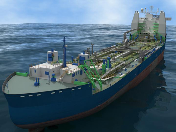
This summer we interviewed project management personnel at Marathon Petroleum Company (Norway) about their use of 3D laser scanning on the conversion of the Multipurpose Shuttle Tanker (MST) Odin (now renamed “Alvheim”) to an FPSO (floating production, storage and offloading) vessel, which will serve the Alvheim field in block PL203 on the Norwegian Continental Shelf. The Alvheim development is operated by Marathon Petroleum Company (Norway) (65%). Other working interest owners are ConocoPhillips (20%) and Lundin Petroleum (15%).
FPSO conversion
The vessel was received by Marathon from Statoil in January 2005. The ship, which was built in 2001 by Izar (formerly Astilleros Espanoles), has an overall length of 252m, 42m beam; it draws 15m and has an 85,300t design deadweight. After conversion, the vessel will have a storage capacity of 560,000 barrels of oil.
The Alvheim FPSO Development has six main elements: drilling and completion of wells; installation of subsea infrastructure; construction of the Turret Mooring and Swivel (TMS) system; hull upgrade; topsides and integration; and operations readiness. This hull upgrade work is being performed at Keppel Shipyard in Singapore. Subsea design and installation is performed by Technip which will include the installation of the buoy as part of the TMS system provided by Advanced Production and Loading (APL) AS, Arendal, Norway. Topside and integration is undertaken by Vetco Aibel with the work mainly being performed in Oslo and Haugesund, Norway. The work includes design and construction of production separators, gas compression and dehydration, water treatment and power generation systems. Integration is the process of amalgamation of the different components associated with the FPSO where as-designed and as-built information is critical. Operations readiness and subsequent operations has been awarded to Maersk Contractors. Marathon is planning for first oil from Alvheim in early 2007.
Laser scanning mitigates risk of mating upper deck to topsides
According to Bryan Wallace, Alvheim project engineering manager, the company deployed laser scanning with the expectation of capturing the as-built dimensions of the vessel upper deck piping and structure, thus mitigating the risk of interferences between the piping, supports, stairs, etc. from the upper deck and the newly designed topsides structure and facilities. Interferences not discovered before mating the topsides modules to the vessel upper deck would have a negative impact on both project cost and schedule. According to Wallace, “laser scanning allows the integration of a 3D model for the brownfield upper deck part of the project with the 3D model of the greenfield topsides.” geovisit();
No existing as-built 3D data
The Alvheim vessel is one of four sister ships and less than four years old. Despite her youth, 3D CAD was not used for the detailed design. Ole Martin Dahle, a member of the engineering team for the project, oversaw the laser scanning project all the way from scope-of-work preparation, justification, and execution, through to final modeling. Although a structural model of the hull was used for structural calculations, the level of detail of this model was inadequate for dimensional control associated with the conversion purposes. According to Dahle, 3D models have not typically been used by shipbuilders. The Alvheim vessel was constructed to IMO DP3 which also allowed for possible conversion to a drilling ship. Building to the IMO DP3 standard requires redundancy in much of the piping and cabling, and consequently the congestion of piping and cabling on the vessel upper deck is significantly increased.
Capnor AS awarded laser scanning services contract
Owing to the critical nature of as-built information as part of the integration process, it was decided to collect accurate dimensional data of the vessel. Following a competitive process Marathon awarded Capnor AS, Stavanger, Norway in September 2004 a contract to perform the laser scanning operations.
Work process
Prior to delivery to Marathon, the MST Odin had been involved in cleanup of the Prestige, the tanker that sank off the coast of Spain in 2002. To limit the risk of rain, which impairs scanner performance, Marathon considered executing the initial scanning in Spain. In the end the team elected to perform the work in Stavanger once the temporary equipment on the deck had been removed. The 2-person Capnor team led by Håvard Sande performed more than 110 scans round the clock for 11-1/2 days using a Leica HDS3000 scanner. According to Dahle, who was aboard the vessel for the scanning, the work proceeded ahead of plan. On completing the initial above-deck scans, the benefits of the survey quickly came apparent and the scope was expanded to include a number of internal rooms where upgrades/modifications were planned. For the scanning period, weather was not an issue.
After completing the scanning, Capnor spent a week checking and registering the scan data and then went straight to modeling using Cyclone. The Cyclone models were then exported to MicroStation and then to PDMS using ImPlant. As modeling work in specific areas was completed, that portion of the 3D model was released to project contractors. The final model of the upper deck was completed in March 2005. Dahle says that as the project progressed, the engineering team and the project contractors saw an ever-increasing requirement for more detailed information. The model information was used to determine the piping that would be demolished and to put in reserve volumes for the new equipment. All of this had to be completed before sending the ship to the Keppel Shipyard in Singapore for the actual modifications. Applying topside clash controls methodology to the scanning-based 3D model revealed significant piping clashes. As this was found early in the design process they were easy to fix, saving significant late “field modifications” which are costly. According to Dahle, finding these clashes would have been much more difficult without the scan data.
Impact on construction
Vetco Aibel is responsible for design and construction of the topsides and their integration into the hull. According to Wallace, Vetco Aibel has pushed the team to deliver accurate as-built PDMS data in order to check for clashes and verify access and escapeway constraints. Wallace adds that Vetco Aibel, as an EPCIC contractor, is motivated to avoid clashes at the construction phase of the project – a task that is more readily accomplished with complete 3D data than with hybrid 3D/2D data.
Overcoming resistance
Repurposing this vessel is Marathon Norway’s first project to use laser scanning. Understandably, the team experienced some resistance in the beginning regarding the benefit of the work. Wallace says that the technology is not inexpensive and consequently this attracted some scrutiny. Laser scanning has already proved to be valuable for the detailed design phase of the project. Wallace says the full value will not be realized until fabrication and follow-on installation of modules.
What needs to be improved?
Dahle says improvements in scanner hardware mean that the time required to capture the data has been reduced significantly. However, Dahle would like to see the modeling time shortened. Part of this is specifying the required level of detail. “The modeling can be done in 20% of the time” if the requirement for a high level of detail is relaxed, says Dahle. The modeling process is still quite labor-intensive. The required level of detail changes throughout the project – at the FEED stage the requirement may well be lower than at the detailed design phase. Not all parts of the project requirement require the same level of detail – the challenge is to partition the work to get the appropriate level of detail required to define the design. This knowledge is gained from experience.
Next steps
A critical element of the project is the connection of the TMS buoy system to the vessel hull. The connection involves the installation of a “mating cone module” into the circular moonpool. Owing to the size and construction methodology, the first time the buoy and the mating cone module will connect is offshore just prior to first oil, therefore it is critical that the system works first time. Dimensional control is key, and by surveying the as-installed mating cone and the as-built buoy, 3D modeling work can be performed to ensure the design tolerances match under all expected conditions.
About Capnor AS
Capnor is a laser scanning service provider headquartered in Stavanger, Norway. Beginning in early 2002, the company has executed more than 100 projects primarily for offshore process industry clients. The company currently employs 15 people and has five 5 laser scanning systems. Capnor recently opened offices in Krakow, Poland, and Houston, TX, USA.
Glossary
FEED:Front-End Engineering and Design. Industry experts often say as much as 80% of the cost of a capital project in the process and power industries is fixed at the FEED phase.
FPSO:Floating Production, Storage and Offloading. A moored ship capable of producing oil from wellhead platforms and/or subsea wells and storing and offloading the oil into shuttle tankers.
IMO DP3: DP3 is a specification from the International Maritime Organization, an agency of the United Nations for dynamic positioning systems. DP3 is the most stringent level requiring the most system redundancy.
Moonpool: The moonpool is an opening through the hull of ship or offshore structure which allows access to the sea but does not flood the vessel.
Subsea Tieback: A system for connecting one or more offshore wells completed on the seafloor to a production facility. The wells are connected with flowlines to move the oil and gas as well as umbilicals which are conduits for electrical and hydraulic signals used to manipulate the subsea tree and thus control the production.
Topsides: The part of the ship or offshore structure which is above the upper deck of the hull and contains the processing and export facilities.
Turret Mooring System: A turret mooring system connects the risers and umbilicals from the seafloor to the floating tanker. The TMS allows the floating tanker to weather vane a full 360 degrees about the turret while maintaining its mechanical, hydraulic and electrical connections. The turret allows the hull to naturally orientate in a heading as dictated by current and/or wind. geovisit();geovisit();geovisit();


.jpg.small.400x400.jpg)
