
Sponsored by Mach9
Around this time last year, Geo Week News covered a new company in the surveying software space, with Mach9 introducing its Digital Surveyor solution for automatically extracting assets from mobile
Recently, Geo Week News spoke again with Baikovitz to catch up on
“Originally, we believed that we were creating some degree of efficiency,” Baikovitz told Geo Week News. “But when we were actually looking at some of the numbers and speaking with some of our partners, what we found was that Digital Surveyor was driving much more value than we originally anticipated and understood.”
As the product becomes more mature and moves further away from that initial release in 2024, new AEC firms and DOT agencies have begun to utilize the tool, and
Baikovitz told Geo Week News that the last year was largely about getting Digital Surveyor out on the market and validating its value with a variety of customers. Crucially, they looked to

As the growing Mach9 team looks to continue improving Digital Surveyor and meet the needs of their customers within the AEC, transportation, and utilities industries, it became clear that the next step was vector feature extraction to go along with their
“No one’s really developed a truly automated system that would deliver results at the quality level that a surveyor needs and expects,” Baikovitz said. “We sought to be the leading company to be able to do so, and we assembled a
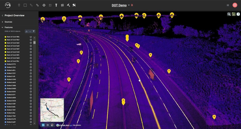
The growth of the company was crucial to getting to this point of being able to offer this new automated extraction feature, as vector features provide more complexity than traditional objects. The latter, as Baikovitz explains, needs accuracy to inches or even feet, but vector features for these survey-grade applications need to be accurate to millimeters. He told Geo Week News that this feature is a “10x harder product to build, and it’s taken a 10x team to be able to get there.”
With these new features available, and the improvements in everything that has been offered by Digital Surveyor since its release last year, customers are continuing to see game-changing results in their work thanks to these automated features.
That includes Fibersmith, a Missouri-based telecommunications engineering firm focused on helping clients build fiber optic networks within and between rural communities. Nick Peña, the company’s vice president, tells Geo Week News that field collection is a major part of their effort to deliver broadband to unserved communities and that they have been using Digital Surveyor for about a year and a half at this point.
Peña continued to say, “We really do have, I’d say a healthy skepticism when it comes to drafting and design aids that we’ve used in the past. So we were expecting that reality wasn’t going to match the packaging. I would say that has definitively not been the case with Mach9 and Digital Surveyor.”
He also called out the value that they have seen with the addition of vector data extraction from roads, saying it’s had a “really big impact” on their post-processing and permitting work. According to Peña, a bottleneck for everyone in their space is permitting, but this feature from Digital Surveyor has significantly streamlined this work.
“The traditional method of exposing [right of way] to permitting authorities – hand drafting with CAD aerial imagery and just kind of tracing either extensive field collection and creation of tie back points, and it’s just an exhaustive process,” Peña told Geo Week News. “And now, with Digital Surveyor, we’re able to drive it out, extract vectors of important features like those edges of pavement or fence lines or other things like that, and have that rendered in a final map product, along with our design, that permitting authorities are willing to trust. And what we really like about Digital Surveyor is that, if [the permitting authorities] are not willing to trust the physical map, we can give them a shared link and say, Well, here’s why we made that decision, and share with them a 3D rendering of the area in question.”
For Russ Hall from Langan Engineering & Environmental Services, being able to derive accurate data is crucial for the firm’s projects. Because of this, Hall says, he will not rely strictly on AI without validating it, which immediately made Digital Surveyor stand out to him.
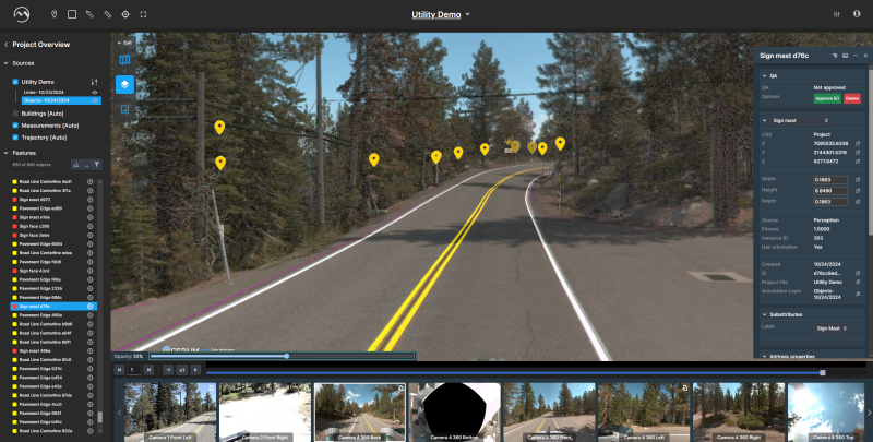
“The first thing I noticed about Digital Surveyor was that the QA tools were phenomenal in it, and they’ve only grown more.” Hall said.
The addition of vector feature extraction has been particularly impactful for Hall, too, given the kind of work they do. Since he and his team have begun using the feature, Hall says that they have run a few projects in parallel with traditional line work to compare both time and accuracy metrics. Now, he says, they’re comfortable to run “all in” with Digital Surveyor. “There’s no backup plan or anything,” Hall said. “We’re confident in it.”
Looking forward, Baikovitz only sees the market that can leverage this kind of solution growing.
“We knew that if we could provide a solution to truly drive improved productivity and efficiencies in how surveyors can make maps faster and better than ever before, then it’s something that many other industries and organizations will be able to leverage too,” he said. “If software is helping dramatically improve this productivity, people are going to see greater degrees of cost efficiency, improve quality, and also, frankly, new types of work that will now open up because of these enhanced ways to generate digital maps in the first place.”
Next month, the Mach9 team will be at Geo Week where they are excited to show off how far they’ve come and discuss how Digital Surveyor can help attendees with their
“That’s what we’re excited to share with people at Geo Week, the amount of progress that
Curious how Mach9 Digital Surveyor can transform your geospatial workflows? Visit us at Geo Week, booth #604, to see it in action! Schedule time with a product expert by reaching out to [email protected].


