
HiPer SR can be used with ArcGIS mobile running on Windows mobile device
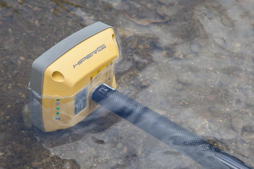
Topcon Positioning Systems, Inc. (TPS) on Monday introduced its rugged, compact HiPer SR integrated GNSS receiver for GIS and mapping applications.
“GIS field work is changing as more field workers are using various types of collection devices like smartphones, tablets, and laptops in addition to the traditional data collectors,” said Jason Hooten, TPS sales manager for GIS. “Unfortunately, the GPS in these devices are not accurate enough for locating buried assets or doing initial inventory collection.”
The integrated receiver can be used to locate buried utilities within an inch one day and the next provide sub-meter accuracy for an environmental study. Scalable options are available via OAF (Options Authorization File) upgrades, generating accuracy levels of sub-decimeter and centimeter without using additional hardware.
The receiver can be paired with a Topcon controller and eGIS software, or used with the company’s eGPS utility software in conjunction with a third-party device and application such as ArcPad or ArcGIS mobile running on a Windows tablet or mobile device. Tracking and positioning is provided by Vanguard receiver technology with advanced Fence Antenna.
Livermore, Calif.-based Topcon designs and manufactures positioning products and software for the global surveying, construction, agriculture, civil engineering, mapping and GIS, asset management and mobile control markets.


