While the applications of lidar are growing, most still involve some kind of mapping or scanning. You can map existing buildings, remote locations, or buildings as they are constructed. As we move towards a future of increasing urbanization, there is pressure to develop cities in a more sustainable way, and to better monitor those cities through the use of sensor data, digital twins, and interconnected “smart” systems.
While the “internet of things” (IoT) field is booming with new connectable real-time sensors that can measure temperature, floor vibrations, humidity and pretty much anything else you can imagine, there’s still a missing piece. How do you monitor the use of building spaces by people - in real time - without invading their privacy?
The answer to this question may be lidar.
When designing or evaluating buildings, especially those in use by the public such as airports, stadiums, transportation hubs and shopping centers, there’s an inherent challenge. You can model the behavior of people before you build the structure to help to optimize it, but ultimately, the way the building is used is sometimes unpredictable or can change in response to major disrupting events (and the COVID-19 pandemic is a great example). Models and simulations can help us understand spaces somewhat, but once built, discovering why certain areas become more congested, for example, can be challenging to quantify.
Some building managers solve this via closed-circuit cameras or other video-based solutions. However, there’s growing vocalization coming from the public, especially in the United States, that are resistant to that type of constant surveillance. Until recently, this was the best solution for this type of monitoring - but there have been several advances that are providing alternative solutions.
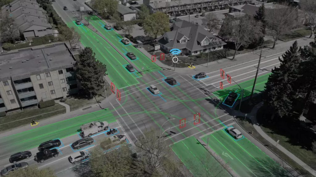
Take, for example, Quanergy. They’ve developed a system that uses lidar, and object recognition algorithms to track people as they move through indoor and outdoor spaces, but without identifying them. Their system uses lidar and AI to collect data into a “flow management” platform, which allows them to accurately and anonymously capture individual of vehicle movements within dense crowds and across large areas. Their perception software, QORTEX, can then feed a data stream into other systems, for example, traffic or pedestrian safety systems, that can adjust traffic flow or reduce accidents. Recently, a people counting system was deployed in South Korea for a busy tourist site.
Lidar maker Velodyne has also jumped in to the smart city arena with an Intelligent Infrastructure Solution (IIS) which combines their hardware and advanced software to solve infrastructure problems with lidar data. Their IIS has been used for so-called “near-miss analytics” that can be used to predict dangerous road safety problems before an accident happents. Rather than installing multiple cameras per intersection that include human lag-time required to analyze their footage, Velodyne’s solution can operate constantly - rather than during a defined traffic study period.
Rather than a static people counter, systems like these could allow for in-depth study of shopping behavior, pedestrian trends, safety or even how well someone is maintaining social distancing - all in real-time, and without identifying the individuals or capturing their faces or collecting personally-identifying information. For some, this may alleviate fears of being tracked - if you’re reduced to a point cloud in a box, that might be enough.
There are two key technologies enabling this - better mid-range lidar sensors, and better AI recognition algorithms. Their convergence may usher in more data streams for building owners and city managers.
Small, low-power, eye-safe lidar can be deployed more easily than other bulky camera systems as well, making their installation more feasible in more places. The lowering cost of such sensors and their decreasing size can make a difference today. Lidar measurements are also extremely accurate, and able to operate reliably in both indoor or outdoor applications, in bright or dark areas, and are not limited by clear weather conditions to operate.
The cities of the future may be mapped by the ever-improving technologies of aerial and mobile lidar systems, but may also be tracked in real-time with applications of lidar running constantly at street corners and busy building lobbies and retail shopping centers.
To keep on top of these developments, in hardware, software and applications - we’ve added a pair of sessions on smart city applications for the 2022 Geo Week conference program, so stay tuned to hear about some cutting edge case studies at the conference.