

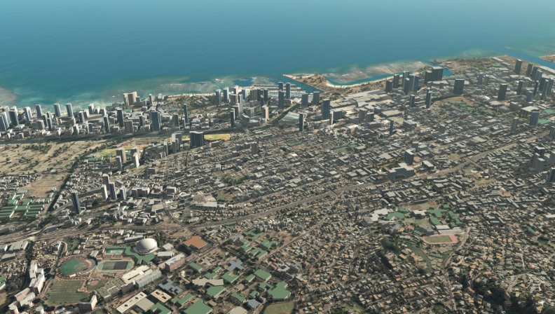
Scheduled for full release this fall, Presagis’ VELOCITY 5D (V5D) is a fast, flexible, and scalable software ecosystem that automatically converts 2D and 3D GIS data into realistic information-rich digital twins to deliver real-time location intelligence and improved decision making. VELOCITY 5D differs by design from traditional 2D and 3D GIS approaches to visualization through seamless integration of spatial (x, y, z), simulation (t) and contextual parameters during digital twin production. The Presagis 5D approach provides customers with simulation-ready 3D content for what-if planning scenarios, such as disaster response, as well as workflow interoperability with leading GIS platforms for decision support.
Presagis’ 30 years of experience in 3D modeling and simulation best-practices provides a unique advantage in delivering digital twin to the geospatial intelligence market. For example, expertise in 3D meshing optimizes the use of shaders, textures and materials at multiple levels of detail (LODs). The result is a digital twin that fully leverages the advanced visualization capabilities of game engine platforms, such as Unreal Engine, and analytical prowess of GIS platforms such as ArcGIS.
Presagis’ focus on digital twins is driven by a growing market demand for holistic 3D geospatial environments that support real-time sensor integration, such as traffic monitoring, open-data standards to avoid vendor lock, and interoperability with existing enterprise investments in GIS applications. Ensuring that Presagis’ digital twin databases meet these requirements has been an essential goal of the VELOCITY 5D product plan. In many respects the digital twin is a natural outgrowth of the emerging open metaverse computing environment where users can pick and choose their visualization and decision-support experience including 3D navigation, 4D scenario planning or immersion using mixed, augmented or virtual reality applications. The Presagis approach to digital twin production will support all of these requirements.
The technological requirements of a digital twin
As a proponent of open-standards Presagis has adopted the Digital Twin Consortium definition of digital twin as: a virtual representation of real-world entities and processes, synchronized at a specified frequency and fidelity. Key technology concepts enveloped in this definition of a digital twin include: (1) the use of real-time and historical data to generate an authoritative geospatial infrastructure; (2) the simulation of predicted futures to de-risk planning and optimize outcomes. The VELOCITY 5D platform is built on these pillars through the adoption of open-data standards, a data agnostic production pipeline, cloud-based architecture, and partnerships with geospatial data providers and software application companies.
Indoor visualization and way-finding are the next big waves in geospatial infrastructure and applications. The miniaturization of lidar sensors and stereo-based image collection camera systems on smartphones makes indoor 3D data collection easy and highly scalable. Presagis is working with partners like Esri to ingest indoor mapping data into the digital twin experience. Although this segment of the geospatial market is relatively new, it is expected to mature quickly along with the growth of the open metaverse. Presagis expects to be a technology and solutions leader in this emerging space with future releases of the VELOCITY 5D platform.
The foundational geospatial data ingredients for digital twin production
V5D solves two major challenges facing GIS professionals overwhelmed by the digital transformation of geospatial data. First, V5D easily ingests massive GIS data sets, accelerating information extraction and delivery through automation for fast conversion into accurate 3D digital twins. Then, the cloud-based VELOCITY 5D platform enables users to visualize complex simulation scenarios to derive context from their 3D data sets, all the while leveraging game engine technology for visualization.
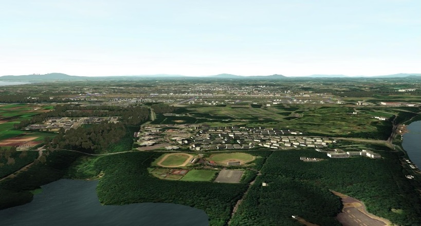
The foundational geospatial data ingredients for digital twin production include terrain, multispectral satellite imagery (MSI), attributed feature data including roads, building footprints, hydrology features, vegetation and 3D models. Presagis has invested heavily in machine learning and computer vision (AI) technology to extract features from MSI to rapidly stand-up digital twin environments where there is no GIS data. In addition, Presagis has developed or acquired multiple libraries of 3D models (airports, landmarks, etcetera). All of these data are used to support customer requirements for digital twin production across the globe. In addition, customer specific datasets are used to generate digital twin environments for railyards, port facilities, military bases as well as natural environments for management of water resources.

From the user perspective the VELOCITY 5D approach is very simple: uses can define an area of interest on the globe and select the layers of information that will be included in the digital twin. A price is automatically generated for the foundational digital twin which can then be modified or enhanced by the customer with their own data in a GIS application. From the beginning the approach has been to keep the workflow simple, the costs low and the speed and accuracy at the highest possible quality.
Supporting digital twin production any place in the world
VELOCITY 5D is architected to be both game-engine and cloud-platform agnostic. At release 1.0 Presagis will support Epic Games Unreal Engine and Microsoft Azure. Presagis has been developing round-earth and 3D database compiler solutions for Unreal Engine and works closely with the Montreal team on geospatial capabilities. The Microsoft Azure edge computing capability for VELOCITY 5D brings its digital twin production capabilities to the point of need for first-responders.
Context expands the digital twin beyond the dimensions of area, space, and time. V5D applies artificial intelligence to extract context, the fifth dimension (5D), from complex geospatial digital twins to reveal patterns of life, human interactions, crowd behaviors, vehicle traffic movement and other relationships. This enables users to better interpret the dynamic world around them and model for future situations.
V5D can generate a nation-wide high-fidelity digital twin from country-sized GIS data sets in hours, not days, and immediately begin running simulation, visualization, planning and mapping scenarios. The VELOCITY 5D platform has been architected from the beginning to support digital twin production any place in the world including under the ocean. In a recent customer project, VELOCITY 5D was used to generate a digital twin of for oil and gas subsea assets including pipelines and other features. The simulation possibilities are endless as both material-based visualizations as well as entity-based capabilities such as assigned agent behaviors are incorporated in a crowd control scenario or traffic mobility within an urban environment.


