

There are dozens of companies and software solutions that have popped up to offer better ways to view 3D models, scans, 360 tours, mapped indoor and outdoor spaces, or drone-collected data. Today, however, Hexagon AB has made an announcement that has the potential to upend many of these solutions by creating one platform that can seamlessly take in and visualize any type of reality capture data: HxDR.
HxDR is Hexagon’s new cloud-based digital reality visualization platform is an all-in-one solution announced today at the 2020 Consumer Electronics Show (CES) that allows users to bring their own data, process it automatically with an auto-meshing feature, and quickly visualize it in a real-world context. Hexagon has leveraged a suite of advanced visualization technologies, AI, and machine learning processes from recently-acquired companies, along with professional airborne reality capture to create the HxDR environment.
Hexagon released their news at a somewhat unusual location, choosing the 2020 Consumer Electronics Show (CES) to announce the new digital reality visualization platform. Usually CES feels like a “shiny-new-toy” focused tech show aimed at consumers, but this year’s CES has already included some surprising product releases that could have applications far beyond the consumer to enterprise and industry.
According to the announcement from Hexagon, users can “drag and drop” their reality capture files into HxDR and the automatic meshing function does the rest.
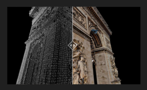
The HxDR platform allows reality capture data from airborne, ground, and mobile sensors to be easily integrated together. The HxDR “Supermesh” is the combination of multiple types of 3D datasets, such as point clouds, laser scans, drone scans, and 3D models, to create a seamless digital representation of the real world. Designed to be user-friendly, this could represent a revolution in the way that reality models are handled and viewed.
Tours and photosphere locations can be dropped into place, and 3D CAD and Object models can also be loaded in geographic context. There is even a subscription-based licensing system for users who want to use real-world replicas that have already been created – a collection of data that includes towns, cities and landscapes and that exceeds 3.6 petabytes in size.
In this example video, dimensionally accurate representations are showcased imagery from inside the HxDR platform.
These real-world replicas, which Hexagon refers to as Smart Digital Realities are designed to be as accurate as possible (like a digital twin), opening up a wide potential of use cases for their development and deployment. Hexagon President and CEO Ola Rollén asserts that this will be significant for the industry.
“HxDR enables customers to create their own Smart Digital RealitiesTM, addressing the growing need for simple-to-create yet highly sophisticated and accurate visualizations of reality capture data that boost project efficiencies and cost savings.”
If there is one challenge that plagues the robust 3D software and design software suites out there now it is that there can a significant learning curve to leveraging their immense capabilities. It seems that Hexagon aims to bring “drag and drop” simplicity to visualization, and remove barriers for integrating different sources and types of data. This ground-level approach could broaden the users of 3D visualizations and scanning immensely if their software is able to strike a balance between usability and versatility.
In the announcement, Hexagon emphasized that HxDR is designed with professionals in mind, but providing them with tools that are easy for anyone to use. They hope that HxDR will help architects to share 3D building designs with stakeholders, allowing them to easily view models within accurate digital replicas of real-world locations.
There have been a variety of recent acquisitions that have prepared Hexagon to create HxDR, added Rollén.
“We’re uniquely positioned to deliver this innovative platform due to the vast library of data captured from our world-leading sensor and visualization services portfolio – a portfolio we continually enhance through R&D and strategic acquisitions such as Technodigit, Luciad, MyVR, and the newly-acquired Melown Technologies. Moving forward, we anticipate HxDR will play a critical role in the formation of smart city and smart nation platforms that will increasingly reflect the needs of citizens today and in the future.”
The existing library of pre-scanned cities and locations could have even more uses, by promising accuracy that could exceed the “street view” type map visualizations currently available from Google, etc., saving costly site visits that are necessary for a variety of industries. It is not hard to envision that these city-scale digital twins could eventually be used for urban planning and development, and could also be used for planners to share proposed developments with the public.
The HxDR is cloud-based and is touted to work with all major internet browsers, and will operate on a subscription-based SaaS platform. There will be payment models that include subscriptions and micropayments based on data processing load and image licensing.
This week, HxDR is being demonstrated in Hexagon’s pavilion at CES 2020 (CP-15), and interested users are invited to apply to be beta testers.


