During the recent Geo Week event in Denver, we noticed a trend that reminded us of three decades ago when in the 1990s, public utilities and municipalities around the world embarked on one of the most ambitious digital transformations of the late twentieth century. Geographic Information Systems (GIS) moved from academic and military circles into the operational core of cities, power companies, water authorities, and telecommunications providers.
The shift was profound. For the first time, organizations could replace decades of paper maps, engineering drawings, and handwritten annotations with a unified digital representation of their assets. It was a revolution in spatial thinking, but it was also a messy, uneven transition. Different departments digitized at different speeds. Engineering clung to Computer Assisted Design (CAD), while operations embraced Geographic Information Systems (GIS). Construction lived in its own world of ‘as‑builts’ and field sketches. The result was a patchwork of digital realities that reflected institutional boundaries more than the physical world they were meant to describe.
Nowhere was this more visible than in the telecommunications sector, where the industry maintained a rigid distinction between ‘inside plant’ and ‘outside plant.’ Inside plant referred to everything within a building, switches, racks, power systems, and structured cabling. Outside plant covered the fiber routes, ducts, poles, manholes, and cabinets that extended across cities and regions.
Each domain had its own tools, standards, and data models. Inside plant lived in CAD, with precise engineering drawings and equipment layouts. Outside plant lived in geographic coordinates, GIS, with spatially accurate maps of networks and rights‑of‑way. The separation was treated as natural, even necessary, but it was ultimately artificial. Networks do not stop at the door of a central office. They are continuous systems, and the digital tools eventually had to reflect that continuity. Over time, the industry moved toward integrated network inventory platforms that dissolved the inside/outside plant divide and created a single operational truth.
Three decades later, the same pattern is repeating itself, this time with GIS and BIM (Building Information Modeling). Once again, two powerful digital disciplines have evolved in parallel, each with its own culture, standards, and software ecosystem. And once again, the separation is becoming a barrier to efficiency, safety, and innovation. The built environment is not divided into “inside” and “outside,” yet our digital tools still behave as if it were. The result is a fragmented understanding of infrastructure at the very moment when cities, utilities, and asset owners need unified, dynamic models of the world they manage.
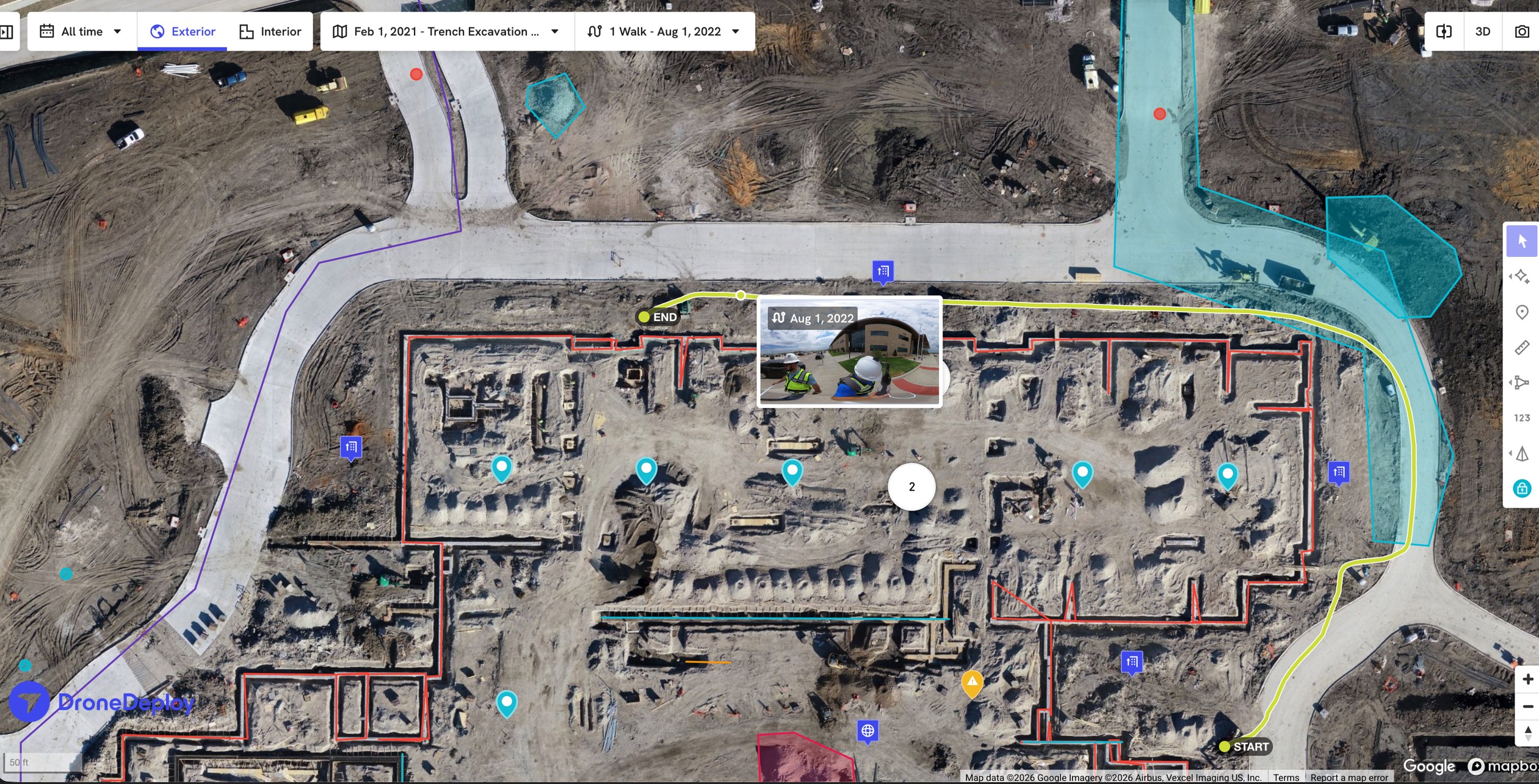
At Geo Week we spoke with Ryan Hippenstiel, a professional land surveyor and Surveyor‑in‑Residence at DroneDeploy (https://www.dronedeploy.com/). The company started in drone mapping and now pulls drone flights, 360° walks, mobile 3D scans, and BIM models into the same environment, one spatial frame of reference where both surveyors and VDC/BIM teams work from the same data.
“What worries many practitioners today,” Said Hippenstiel, “is not that we are collecting too much data, but that we're collecting it in a dozen different ways and we need to make sure it actually lines up. Modern sensors are extraordinary, but if one drone flight does not match the next, or if an interior model floats relative to a scan on the ground, you end up with a very precise picture of the wrong reality.”
The roots of the divide lie in the origins of the two fields. GIS emerged from geography, surveying, and municipal planning. It is concerned with spatial relationships across landscapes, parcels, roads, rivers, utility networks, zoning districts, and environmental systems. Its coordinate systems are global, tied to datums and geodesy. Its purpose is to understand how things relate to one another across space and geography.
BIM, by contrast, grew out of architecture, engineering, and construction. It is concerned with the internal geometry of buildings, walls, beams, HVAC systems, electrical conduits, and structural loads. Its coordinate systems are often local, defined by project origins rather than global reference frames. Its purpose is to model the built form with millimeter‑level precision and form the basis for the preventive maintenance of the edifice.
These different origins created different professional cultures. GIS practitioners think in terms of regions, networks, and spatial context. BIM practitioners think in terms of components, assemblies, and construction sequencing. Each domain developed its own standards, Industry Foundation Classes (IFC) and Autodesk’s Revit on one side, geodatabases and ESRI’s shapefiles on the other. Each domain built its own software universe, with limited interoperability and little incentive to bridge the gap. The result is that cities and utilities today maintain two digital realities that describe the same physical world but cannot easily talk to each other.
“This convergence is not just a software‑vendor vision but a practical response to the way work is already being done.” Said Hippenstiel, “It describes surveying and geodesy as the pin you drive through every layer; drone maps, 360° walks, mobile scans, BIM models; so that they align in the same coordinate frame. You fly the site, walk the building, bring in your model, and it all has to share the same spatial reference if the answers are going to mean anything.”
This fragmentation is increasingly untenable. Buildings do not exist in isolation. They sit on parcels connected to transportation networks, drainage systems, power grids, and communications infrastructure. A water utility cannot fully understand its system without knowing how pipes enter and move through buildings. A city cannot plan for climate resilience without integrating building‑level detail into flood models, heat maps, and emergency response plans. A transportation authority cannot optimize mobility without understanding how stations, tunnels, and platforms interact with the urban fabric around them. Yet today, GIS and BIM remain separate silos, forcing organizations to stitch together incomplete models at precisely the moment when they need a unified view.
The solution is not to choose one system over the other, but to recognize that both are essential components of a larger whole. The future lies in the creation of true digital twins, dynamic, integrated representations of the built and natural environment that combine the strengths of GIS and BIM into a single operational reality. In a digital twin, BIM provides the internal geometry and systems of buildings, while GIS provides the external context and networks that connect them. IoT (Internet of Things) sensors supply real‑time data. UAS and lidar provide continuous updates. Asset management systems supply operational intelligence. The digital twin becomes the source of truth, and GIS and BIM become specialized lenses into that truth.
This convergence is not theoretical; it is being driven by powerful forces across the infrastructure landscape. Cities pursuing smart‑city initiatives cannot manage transportation, utilities, zoning, and resilience with fragmented models. Utilities modernizing their grids need seamless integration between substations, feeders, and building‑level connections. Construction owners increasingly demand that BIM models survive beyond construction and become operational assets, which requires integration with GIS. Climate adaptation efforts require building‑level detail embedded in regional models. And digital twin platforms from companies like Bentley, Hexagon, ESRI, Autodesk, and Siemens are already moving toward unified spatial‑BIM environments.
The parallels to the 1990s are unmistakable. Just as the inside/outside plant divide eventually collapsed under the weight of operational reality and potential savings, the GIS/BIM divide is now reaching its breaking point. The organizations that embrace convergence will operate more efficiently, respond more intelligently, and plan more effectively. Those that cling to the old silos will find themselves managing two incomplete versions of the truth, unable to fully leverage the power of spatial intelligence in an increasingly complex world.
The lesson from the past is clear. Digital transformations succeed when they reflect the physical and operational realities of the systems they represent. In the 1990s, GIS helped utilities and municipalities break free from the constraints of paper maps and departmental boundaries. Today, the next leap forward requires breaking down the artificial wall between GIS and BIM. The built environment is a single, continuous system. Our digital tools must finally catch up, but when they do, the digital transformation that began in the 1990’s will finally be complete.