

As is the case every year at Geo Week, the first morning of the 2025 edition of the event featured our product previews, giving companies from around the industry a way to showcase their latest offerings. This year’s previews included 22 presentations, which took place across two rooms Monday morning. At Geo Week News, we will be briefly covering what each company had to say through three different articles over the next three days, continuing today with a look at products relating to 3D software in the presentations.
Veerum
Presenting on a similar topic, Roy Hebert presented for Veerum, talking about the company’s own digital twin platform. Right now, he says the company is largely working within the energy, oil & gas, utilities, and mining industries, but they certainly are not the only sectors that can and should be taking advantage of these tools. Hebert ran through some of the capabilities of the platform and the value their customers are getting from it, including improved productivity, reduced field time, and lower costs. Additionally, he called out the importance of collaboration with industry partners, noting that Veerum does not collect the data and is always open to partnerships with firms that do.
Hexagon
While Leica Geosystems, part of Hexagon, presented on their aerial topographic and bathymetric surveying capabilities in one room, the other featured a presentation from Mike Harvey about the company’s reality capture software. He ran through the various features around Cyclone FIELD 360 and Cyclone REGISTER 360. Harvey ran through some of the crucial features of these tools, including georeferencing features, and how they can create a cohesive ecosystem between the company’s reality capture hardware and this kind of software.
Esri
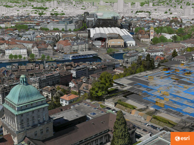
Most people know Esri for their ArcGIS platform, traditionally working in 2D for a variety of use cases layering multiple datasets on top of one another. Their presentation on Monday, given by Arek Szadkowski, however, focused on 3D, reality mapping, and digital twins. Szadkowski talked about how Esri’s platform can take in imagery from just about any altitude – from satellite to crewed aircraft, to UAV, to ground-based systems – and create 3D base maps tied to geography, opening up many different possibilities. He ran through some of the use cases for this technology, including but not limited to flood and wind simulations, and talked about the journey for digital twin adoption. He told the audience toward the end of his presentation that digital twins cannot be bought – they’re built with specific use cases in mind.
3Dsurvey
3Dsurvey Product Manager Marko Mesarič told Geo Week Product Preview attendees that the company is “special” because its software is “developed from real experience.” Drawing on its work with more than 70 clients worldwide in surveying, construction, mining, and many other fields, 3Dsurvey has developed digital processing and photogrammetry tools that feature the company’s integrated CAD engine, complete workflow for volume integration, and RTK videogrammetry system. In addition, Mesarič said, the 3Dsurvey’s software enables multiple device integration, including GNSS, SLAM, and photogrammetry, and its 3D survey cloud allows for data to be shared with multiple clients.
Bentley Systems
According to Bentley Systems solutions engineer Jakob Howard, his company is committed to “providing solutions for design, construction, operations, and maintenance.” Their software is aimed, Howard said, at “advancing the world’s infrastructure” and helping public works, transportation, and related professionals integrate geospatial technology and digital twins into their work. To these ends, Bentley has engaged in some recent partnerships and acquisitions. For example, Howard explained how the company is continuing its partnership with Google to leverage digital twin technology, and it acquired Cesium and Seequent. Looking forward, Howard said that Bentley is looking to further leverage artificial intelligence to help engineers remove “monotonous tasks” from their work and focus more on actual engineering.
Skand
Makers of web-based spatial data management & visualization software, Skand presented its vision of creating a software platform that allows users to “visualize, analyze, annotate, extract intelligence and share digital representations of physical assets.” Central to Skand’s mission is the desire to eliminate the “disconnect between business and spatial data.” The company hopes to bring technologies such as digital twins and AI to “non-sophisticated users” and provide flexible solutions that enable users to implement these systems in ways that complement their existing strategies.

.jpg.small.400x400.jpg)