On Friday, June 5, ClearEdge3D released its flagship product, EdgeWise. This product got a lot of attention on the SPAR 2009 exhibit floor in March, and CEO Kevin Williams kicked off a standing room only session with his discussion of the product. Now you can buy it. The launch was postponed about a month so that Williams and his wife, Lesa, could incorporate many of the suggestions and requests they received from interested customers at the conference. Read on for those particular improvements.
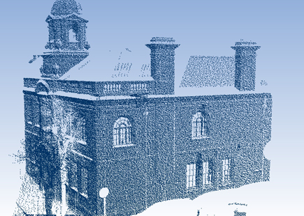
Williams dedicated his SPAR 2009 demonstration to all the office techs unable to attend the conference because they were stuck manually extracting CAD models from point cloud data. His company’s solution alleviates this bottleneck by automatically converting point clouds into 3D polygon models—what Williams called the “gold standard” in the 3D modeling world. Polygonal models better communicate and expand the 3D world, even to non-technical users, he said. Consumer-level 3D products, like video games and Google Earth, all use polygons rather than point clouds.
The concept of polygonal models isn’t new, but the ClearEdge3D solution is. EdgeWise does not merely create a decimated mesh like most other automated applications. EdgeWise algorithms fit exact polygons to surfaces with actual edges in the scanned object—all automatically. The software can also build a design-intent model—if two planes are supposed to be parallel to each other, for example, then EdgeWise will snap them to become exactly parallel (as long as they’re within the user-specified tolerance). “In 90 percent of the cases, say if someone is trying to figure out how out of skew a wall is, they’ve still got to compare it to the vertical information (the ideal model). If they really want the nitty-gritty, real-world, as-built details, they don’t want a CAD model. The raw point cloud is actually the answer,” Williams says.
The full-featured viewer within Edgewise lets users analyze and display data in a point cloud as well as classify points. Classification is based on coplanar points (cylinders and other parabolic shapes are promised in the future), which are clumped into a cluster and colored. From there, EdgeWise creates highly accurate solid models from the mathematically fitted surfaces to the clusters. Users can then make a complete solid model by exporting the data into DXF format and importing them into a preferred editing application like AutoCAD, SketchUp or MicroStation where it can be manipulated and where the polygons can be snapped one from another to be sure the original high accuracy from the original fit to the point cloud data is maintained. Pictures can then be lined up to automatically photo texture the model.
In addition to modeling planar structures, EdgeWise will also automatically model topography (ground surfaces). In more complex terrain, Williams says the algorithm will go up and down ridges and hills, collecting just the points that fall on the ground surface—a feature good for GIS purposes. EdgeWise then colors the clusters. Clusters and underlying TINs can be exported.
Since the SPAR conference, ClearEdge3D has improved the processing speed so that typical scans take between 5 and 45 minutes, depending on the number of points, complexity of the scene and parameters set. Modeling, of course, takes longer. Since the algorithms are based on least squares regression, Williams claims the final models are as good as the data itself (read: accuracy is high). Pre-registered scan data are now supported, as are .pts and .ptx file formats and the merging of multiple scan sets.
Who is this good for? Williams says 60 percent of people currently interested are in the BIM community. Certainly security modeling, infrastructure modeling and BIM apps will respond to this solution, as will the video gaming industry, the real estate market and Hollywood that seek more real-world data. The growing need for cellular coverage maps could benefit, too. Williams also notes that, in the next three to five years, virtual conferences and virtual tourism will take flight, Google Earth will have higher resolution 3D models, and smart phones will be enhanced. Millimeter-precision geo-location—big with government agencies for corridor jobs—will like this. The software doesn’t work with free form surfaces or other primitive surfaces yet, but users should stay tuned. Mobile scanner users should also stay tuned for a solution.
EdgeWise launched Friday with a price point of $4,995 and a 30-day guarantee. “The pricing strategy is meant to include as many customers as possible who need or want to incorporate the efficiencies of automated technology,” Williams says. “We, therefore, chose a price that would let most people see an ROI within a few weeks of use. We think that automation holds the key to really igniting this segment of the marketplace. We believe this industry will grow tremendously with the injection of this new technology.”
ClearEdge3D is offering a series of online demos on EdgeWise; see the schedule here.
Automation, Williams says, is the key toward driving the laser scanning market to the next level. We think most would agree with that.