
Pericept’s BIMtrace offers lightweight reality capture for AEC. The solution enables users to QC the as-built against a 3D design model in Navisworks, communicate an issue to their team, and even grab accurate real-world measurements–all of this from a single photo taken on an iPhone or iPad.
Company founder and CEO Tony Ragucci says BIMtrace was designed to be so accessible and cost-effective that it “embeds quantitative reality capture in the standard construction workflow, right along with punch lists and change orders.”
I caught up with Ragucci to find out how BIMtrace works, how far its functionality extends, and the clever processing method that makes it possible.
Using The BIMtrace App in the Field
When you open the app for the first time, Ragucci says, you perform a simple calibration for the optics of your device. Next, you pull up a 2D map of the site as exported from Navisworks and indicate where you’re currently standing, as well as what direction you’re facing.
Then you snap a photo.
The process is designed to be very easy for field workers to use. “You don’t have to do anything different than you do now to use it,” Ragucci says. “Instead of taking photos with your regular camera, you take those with BIMtrace instead. It takes about the same amount of time but all these photos become quantitative—and you can mark them up any way you want to.”
Using The BIMtrace Plugin in the Office
Once you’re back at a desktop computer, you open the photos in the Navisworks plugin and align them to the 3D model.
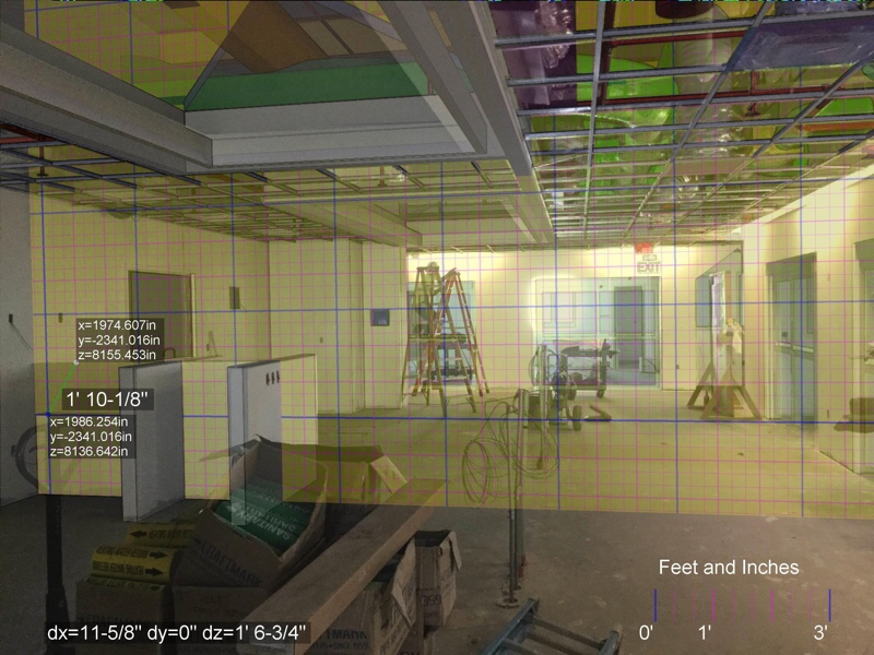
This process is as simple as selecting four edges in the model and matching them, one at a time, to the corresponding edges in the photograph. Essentially, you’re tracing the photograph to the model and performing a pixel-wise registration. (This tracing process gives the solution its name.)
Afterwards, you can turn on the overlay and see whether the construction in the photograph aligns with the model—for instance, to see if sprinkler lines were placed in the right place. You can also grab quick, accurate measurements. If a wall was meant to extend halfway out in the room but it extends farther, you can take a quick measurement to see how much farther.
As an added benefit, Ragucci notes, BIMtrace photos can also be attached to projects in construction management software like BIM360 Field or Procore. “So if you do have an issue that comes up, like a cost-change event,” he says, “all your documentation is built right into the issue itself. You don’t have to go back and compile that information after the fact.”
A Low Barrier to Reality Capture
In Ragucci’s words, this approach makes BIMTrace “a lightweight version of reality capture that’s accessible to anyone.”
Compared to laser scanning, which requires extensive training and expertise, the BIMtrace capture process is intuitive enough for anyone to perform. It also produces data sets that are significantly smaller than point clouds—small enough to transfer using services like Dropbox, Google Drive, or even email.
Pericept has also priced the BIMtrace solution aggressively. They offer the mobile app for taking photos in the field as a free download, and requires no account signups for use. That means anyone on your team can help with the capture process.
Organizations pay only for the Navisworks plugin, which is sold by the floating seat. If you have a small team, buy one seat and share it. As your team grows, scale it up by buying more seats.
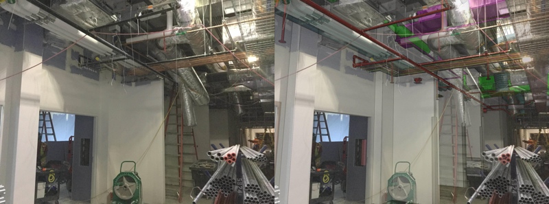
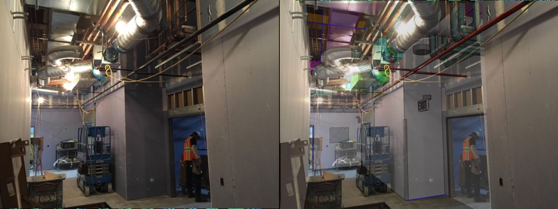
BIMtrace can be used to document and QC MEP installations. Left: Site photo, Right: Photo and model aligned
A Complement to Lidar
Ragucci is careful to note that BIMtrace should be thought of as an augmentation to laser scanning, not a replacement. If you’re already scanning regularly in the field, he says, “BIMtrace is a good way to do spot checks. You can cover a lot more space quickly because you’re using photographs.”
But is BIMtrace accurate enough? To test the solution out, Pericept asked a client at an industrial plant to take some photos and give them to a third party. They then asked that third party to align those photos to the model in the Navisworks plugin and take a few measurements.
When they compared those measurements to the laser scanner measurements of the same site, BIMtrace was off by about 3/8 of an inch.
Communicate with the team using geometric overlays.
BIMtrace vs. SLAM
I asked Ragucci if BIMtrace was susceptible to the same problem as handheld scanners, which gather very accurate dimensions in small areas but can have trouble with large sites, outdoors, or in bright light. Surprisingly, he said no.
“A lot of those tools for generating a scan are generating a priori,” he explained. “There’s no existing model, and so they’re building everything on the fly. It’s impressive, but there are limitations.”
BIMtrace, on the other hand, leverages the original 3D design model as a basis for comparison. In the field test mentioned above, that enabled the solution to produce accurate measurements even at an average range of 50 feet. “It’s the combination of the two” Ragucci says, “the 3D model and the registered photograph, that gives you that capability.”
For more details about BIMtrace, including pricing information, visit pericept.com


