
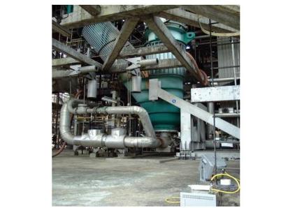
Pertamina, the state oil and gas company of Indonesia, commissioned laser scanning to survey a 10-storey reactor/regenerator in its Balongan Refinery in “hot” or operating condition – a major advance over traditional cold surveys, when dimensions are significantly different.
This project required capture of precise dimensional detail on the expansion links (standpipes) between two large structures in the refinery, an 80m-tall reactor and a 40m-high, 16m-diameter regenerator. Temperature changes cause the two structures to move at different rates. This movement “is taken up by an expanding bellows joint,” according to Paul Blackadder, an expatriate Australian professional surveyor and technical director at PT TeamworX Indonesia, which executed the survey. “There was an alignment problem in the standpipes that connect these two parts of this reactor facility,” causing the bellows to jam. The bellows joint is fabricated outside Indonesia and costs on the order of $250,000 to replace.
During a routine shutdown, it was planned to make adjustments to the alignment, but the amount of adjustment could not be calculated without first knowing the exact alignment during operation (hot condition) and then comparing it when in its cold condition immediately after shutdown. The adjustments consisted of changing the angles between the upper and lower standpipes and their spoolpieces by cutting at the field welds. Thus it was necessary to quantify the angles and alignments of the centerlines of the various elements.
The facility “operates at around 400 degrees Celsius,” Blackadder reports. “There was no way of measuring it by conventional means because you can’t get near enough – the facility is too hot.” Laser
scanning was determined to be the only way that accurate, timely, highly detailed information could be obtained, and most of it could be done from the concrete reactor floor at ground level. Although the top of the upper standpipe is more than 20 meters above the ground, scaffolding could not be erected due to requirements to carry out other work nearby. Time was also a factor – there were only limited windows of opportunity to scan, immediately before and then after shutdown.
Owner expands scanning project to gain 3D digital model for future expansions, modifications
PT TeamworX Indonesia is a Jakarta-based multidiscipline consultancy that provides construction management services (project management, contract administration), engineering design and 3D laser scanning services. The company was established by professionals with 20-year-plus backgrounds in engineering and surveying and with many years in the construction industry in Indonesia. This was the first major laser scanning project undertaken by TeamworX. “Laser scanning is the surveying technology of the future for capturing existing condition (as-built) information,” Blackadder believes. “It’s revolutionizing how we do as-built surveys. I’ve made more than 40 presentations to companies and interested groups, mainly in the petrochemical industry, in the last
12 months, and the ‘wow’ factor response is common.”
Pertamina commissioned TeamworX to survey the structure in hot condition, then again in cold condition, and compare the maximum and minimum dimensions. Additional detail to capture included all the steel support structure, and all major pipelines and fittings, in order to assess the potential for de-bottlenecking.
PT TeamworX carried out scanning and point-cloud processing during August and in September 2003. “Within one day of scanning we measured that standpipe area in hot condition,” Blackadder reports. “About five days after shutdown we went back and measured it in cold condition, and produced a 3D model and 2D drawings in AutoCAD within 24 hours of survey. We measured the difference between the hot and cold condition, and from this information the client determined the amount of adjustment whilst in cold (shutdown) state so that once hot, it would line up.” The difference in alignment between hot and cold conditions was about 200mm.
Available as-built information for the plant was typically marked-up paper design drawings. There was no digital information, and the client was looking to develop a CAD-based as-built database. Final deliverables were to be a 3D AutoCAD shell model, with 2D plans and sections for the standpipe area, along with the point cloud viewed as a reference object through CloudWorx for AutoCAD.
“The owner decided they would also commission us to do the complete RCC unit so that they would have a complete 3D digital model that they could then use for further expansions and modifications down the track,” Blackadder reports. “All the documentation they had before this on the project was paper drawings.” This exercise was also an opportunity to assess 3D laser scanning as a means of building a complete digital plant model for planned future computer-based asset management.Scanning: 7 days hot, 5 days cold, 1 day post-modification alignment check
The survey team consisted of 5 personnel, 3 surveyors, 1 chainman and a CAD operator. Equipment included a Cyrax 2500 laser scanner, Leica TC1600 total station, Wild T2 theodolite and Leica NA2 automatic level. Work hours were restricted to the day shift due to permit requirements, and were from 8:00 am to 6:00 pm daily.
In all, “scanning the original hot conditions took about seven days. We went back after the plant had shut down, and did another five days of scanning in cold condition. Then there was a third trip – they called us back, extra to the original contract, to do an alignment check after they had cut the standpipe, adjusted it and tack-welded it in its new alignment. For that we went back and did one day of scanning to check the alignment.” Blackadder reports it was pleasing to do the calculations and find that they had in fact gotten within 5mm of the proposed alignment, which would result in the structure being well within tolerances once heated to its operating temperature.
Unlike scanning inside dense plants or on offshore platforms, where the scanner has to be moved many times in order to “see” all the detail behind the congestion, onshore scanning could be done further away, up to 50m, which however increased the time spent at one location since many scans were required in order to get the required point spacing.
Survey control was established from known reference points supplied by the client engineer. However, large discrepancies between given distances and actual distances of the reference co-ordinates, resulted in using grid lines defined by structural steel as the correct positions. In the end it was assumed that the structure was in the correct place and the survey control was not. Heights were controlled mainly by several tape drops with checks against reciprocal trig heighting, each storey had no more than 3mm misclosure in vertical heighting. This was crucial to controlling the expected height movement due to temperature variations of the regenerator.Targetless registration critical – heat of refinery can melt targets
“We did field registration as we went, then another week or 10 days of registration in the office,” Blackadder reports. “We ended up with over 200 scan-worlds. We used a lot of point-to-point registration.” This is a particular strength of Leica/Cyra’s Cyclone software, according to Blackadder, and was critical to the project. “In Cyra’s software, one thing I really liked was the ability to directly register clouds point-to-point. There were areas we couldn’t put targets up – targets would melt before they even got near the fixture. In many operating plants, we’ve found you can’t put targets where you want.”
All scans were initially registered together using overlapping features within the point cloud only. This increased the number of scan positions, to around 100, but gave higher confidence that the scan data fit together well. Targets were used sparsely, mainly to control the overall orientation and for added quality control between non-related scans. Registration was highly reliable, with standard errors no greater than 5mm, allowing precise dimensioning and modeling of the required elements.
During the two weeks it took for the facility to cool down prior to the “cold” survey, scan data was converted to models using Cyclone. “I ran two modeling crews working in shifts on one set of software,” Blackadder says. “It took about 150 man-days to model. They really wanted a compete package. We were modeling right down to 2-inch pipe in this huge, complex plant.”
Data transfer into AutoCAD “was no problem at all, just a click of the button almost. We put up different layers for the different elements. In all, 43 different layer names and colors went across into AutoCAD
beautifully. The client also requested that we produce MicroStation files for future use with Intergraph PDS. This was a simple exercise, as MicroStation can open DXF files and create DGN files.”
In addition, the client received the registered point-cloud data. “We also supplied CloudWorx Pro for AutoCAD to the client so they could open the point cloud, and we ran a training course for their people,” Blackadder explains. “We didn’t model every element of the whole structure. There are some elements they might want alter later on, so this way they can model them from the point cloud. That was just a little extra bonus we put in to promote the technology to the owner.”Cyclone strong in registration and modeling, but big databases can bog it down
“I’m a fan and a complete convert to this technology,” Blackadder says. “The equipment really does the job wonderfully. I recognize that scanning equipment is still embryonic in its development, and Cyrax
2500 is limited in some applications in having only a 40-degree window, but these issues are all being addressed by Leica Geosystems’ new HDS scanners coming on the market now. I remember the revolution that the HP35 hand calculator made in field surveying in the early 1970s. No more referring to trig tables. EDM, the total station and data recorders progressively changed traditional surveying forever, or so we thought until the laser scanner. Now it is the way of the future. That does not mean however that surveying can be done by just anyone. Surveyors can now use their specific geospatial skills to concentrate on planning projects and tailoring to clients’ specific requirements by delivering more complete datasets with complete confidence, without spending so much time on the mechanics of mathematical computation.”
“While we were planning the project,” he continues, “Cyra released version 4.2 of Cyclone, which allowed modeling of cylinders directly without having to segment.” With Cyclone, “it’s very easy to model once you get the hang of it.”
“A limitation in Cyclone at the moment is it does sometimes bog down with a large database,” Blackadder reports. “We had a 4Gb database to work with. You have to constantly switch point clouds to make it perform. We arranged the point cloud so we could step through it in sections. We kept the whole model database alive, but broke it up so we could step through a piece at a time. It was a continual operation of stepping though, section by section. This structure was 80m tall, so you’d work
through the scan data in 10m-15m cubes, using cut planes and limit boxes. But they tell us that Cyclone 5.0, due in the next few months, is expected to reduce the modeling time dramatically, and also will be handling much larger databases. We’re looking forward to it with baited breath.”On-time restart crucial to Jakarta’s gasoline supply
Besides being the only feasible way to survey the standpipes in hot condition, laser scanning was chosen for its speed and accuracy of data capture – both important to safeguarding project schedules. Balongan Refinery fulfills all of Jakarta’s gasoline requirements. Because Pertamina had to buy gasoline from the open market during the shutdown, any schedule delays would have had a direct cost impact. Safety was also a major benefit, as survey staff no longer had to erect scaffolding or climb over structures.
The final data delivered was transparent from the traditional survey measurements taken, Blackadder reports, and the ability to use the point cloud for visualization helped give the owner confidence that the data was correct. Having a virtual 3D site, sitting on a PC, using mainstream right the first time – something Blackadder notes was proven during the standpipe check alignment survey.


