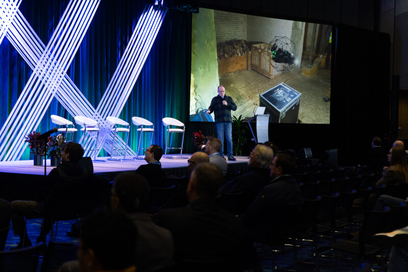
“Name me a medium that provides context better than reality capture? I mean, not since the photograph has anything like this appeared and excited people.”
That was how Pete Kelsey, owner of VCTO Labs LLC, opened his presentation at Geo Week 2025 entitled Capturing Alcatraz: A Unique Gathering of Technology and Talent. The 40-minute talk dove deep into a fascinating project started in late 2023 in which Kelsey, along with a host of colleagues from companies and organizations from every corner of the geospatial industry, collected reality capture data for the entirety – inside and out – of Alcatraz Island in San Francisco, California. The project has been covered by numerous outlets, including the New York Times, and attendees got a first-hand account of the project from Kelsey, as well as an up-close look at the incredible data that came as a result of the work.
As he explained to the packed room, this project originally came about with Alcatraz, which operates under the National Parks Service, trying to plan for the future of the island. Specifically, they wanted to anticipate some of the potential effects of sea level rise in the area. Kelsey recognized that reality capture would help with that, and asked about their digital assets. Their response? “Digital what?”
It wasn’t an unexpected answer, of course, but Kelsey laid out the idea to scan the island in its entirety to “establish a baseline dataset to which all future survey scans can be compared for change detection.” And with that, the project of a lifetime was launched.
In this presentation, Kelsey then talked a bit about the history of the island, noting that much of this history would actually be seen in the data later in the talk. He went all the way back to the Native Americans settling in the area as far back as the Ice Age, with San Francisco really starting to build up in the mid-1800s with the gold rush. At that time, the Army decided to fortify the bay and build a fort on Alcatraz, the first building on the island. He then ran through some of the most infamous inmates that stayed in the penitentiary, some of the legendary escape attempts, and protests on the island after the prison was ultimately closed.
After setting that baseline history of the space, Kelsey dove into the logistics of this project, which needed to be completed in just three weeks. Because of this, he explained, they couldn’t rely on the ferry schedule to get to and from the mainland – so they asked to sleep on the island. The Parks Service told them they could; they’d just have to sleep in the cells. As the project progressed, Kelsey gained access to keys for anywhere on the island – “Don’t do anything stupid, and don’t get hurt,” he was told – and there were areas scanned that hadn’t been visited in decades.
In listening to Kelsey talk, it’s clear that the biggest takeaway of the entire project is the amount of collaboration and different expertise needed for the project. There were representatives and equipment from nearly every major company in the industry, many of which were competitors. There were Hovermaps from Emesent being used for areas, terrestrial scanners from RIEGL, drones from companies like Freely Systems and Flyability, Boston Dynamics' Spot the Dog, and many, many more competitors to mention, all working together for the project. Even more incredible, there was no money involved.
“Nobody got paid, including me,” Kelsey said. “It was 100 percent pro bono. So the first challenge was, Hey, you want to come help me scan Alcatraz? There’s no money in it.”
Despite that, he shared that no company or person said no, and that the collaboration was really what made this project work. Because of this, he made a point to list out every company on both the hardware and software side involved in making this work possible and took a moment to let everyone involved stand up for those in attendance. Kelsey referred to himself as largely being the “project manager” for this work, which would have been impossible without everyone else involved.
Toward the end of the presentation, Kelsey also shared a number of stunning models created with all of this lidar and photogrammetric data, some of which he’d just received literally the night before the talk. The data included many of the pieces of history he mentioned at the top of the presentation, including remnants of the Citadel – that original fort built by the U.S. Army – and a detailed scan of the path taken in the infamous Escape From Alcatraz. Unfortunately, it’s impossible to do this data justice with just words, but Kelsey did share a snippet on LinkedIn, which you can see below.
This is the perfect example of the kind of work that wouldn’t have been possible even just a few years ago, fusing together data from a variety of sensor types and manufacturers – though that work is still ongoing. Now, the question becomes what can you do with the data? I’ll let Kelsey explain that how he’s always explained what can be done with reality capture data.
“When I was in enterprise sales in tech, and reality capture came along, after a customer would see the data they’d ask, Well, can we repurpose the data for - And I would interrupt them. Yes. They’d say, Wait, can we - Yes, you can. You can do anything you want.”


