
Applications for hyperspectral sensors include precision agriculture, oil and gas exploration
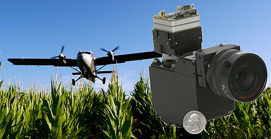
Headwall Photonics Inc. has rolled out a new, compact, hyperspectral imaging system for manned aircraft and unmanned aerial vehicles (UAVs).
Typical uses for airborne hyperspectral sensors include precision agriculture, oil and gas exploration, forestry management, and environmental monitoring.
Based in Fitchburg, Mass., Headwall said its new system features its Micro-Hyperspec hyperspectral sensor, and also includes a GPS unit, a lightweight data processing unit, and airborne-specific hyperspectral software providing image acquisition, sensor control, and synchronization for flight-plan efficiency.
Headwall’s Micro-Hyperspec sensor based on the company’s patented aberration-corrected sensor design, which allows very high signal-to-noise characteristics, a very wide field-of-view, and high spatial and spectral resolution.
Hyperspectral sensors look at objects using a vast portion of the electromagnetic spectrum and run at very high frame rates to capture precise imagery.
“All across the remote-sensing landscape we’re seeing a need for precise, accurate, data-rich hyperspectral imagery using increasingly smaller airborne platforms,” said David Bannon, Headwall CEO. “Customers need solutions that are small and light, and they need them to be fully integrated between the sensor, software, GPS/INS, and data-processing hardware.”
Headwall designed the system to optimize the configuration of size, weight, and power (SWaP), which are critical for airborne missions.
The company’s sensors are used for remote sensing, advanced machine vision, pharmaceuticals, biotechnology, and mining and mineral exploration.


