
Neptec commercializes space technology for use on Earth
Neptec Technologies Corp. launched its first products Wednesday with a range of obscurant-penetrating 3D laser scanners designed for robotics and machine automation applications in harsh environments and a software development tool kit (3DRi) that extracts real-time features of an object from a point cloud for users of next-generation 3D machine vision products.
Ottawa-based Neptec Technologies was spun-off from space flight technology firm, Neptec Design Group Ltd., as a separate company in 2011 to take advantage of 20 years of technology innovation for clients such as NASA, including solving mission-critical problems for its Space Shuttle program, by adapting it for terrestrial commercial use.
Specifically, Neptec developed highly efficient 3D data algorithms and real-time software for automatic change detection, 3D data alignment and object recognition and tracking.
The company said its first products are “out-of-the-box building blocks” to help develop intelligent 3D machine vision applications for autonomous off-road vehicles and more familiar lidar-based survey and measurement tasks in harsh environments.
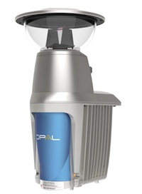
OPAL laser scanners for emergency response
The OPAL 2.0 laser scanners leverage Neptec’s OPAL technology – Obscurant Penetrating Auto-synchronous LiDAR, a unique time-of-flight laser scanner with a clear mode and an obscurant mode. The 3DRi software, featuring automatic change detection and object recognition, switches between them.
OPAL laser scanners can see through smoke, and was originally developed to handle emergency response situations, such as helping helicopter pilots avoid accidents landing in desert brownout conditions.
The laser scanner is also packaged for the punishing conditions typical of off-road vehicles and mapping sensors used in the mining, oil and gas, and construction industries.
The 3DRi (3D Real-time intelligence) point cloud processing software provides automatic scan alignment without reference markers, automatic change detection, automatic object recognition and tracking, and automatic image analysis for measurement taking.
“To take on greater autonomy, machines need 3D sensors that can give them an accurate view of their surroundings, and intelligence to interpret that input and react appropriately to the situation,” said Mike Sekerka, Neptec Technologies COO. “And it all has to work in real-time, while moving, in harsh environments and unpredictable situations.”
Neptec Design Group manufactures real-time 3D sensor, software and robotics technologies for the space market but identifies the mining, oil and gas, construction, automotive, defense, and homeland security industries as “increasingly turning to these technologies to improve safety and productivity, and reduce costs.”
More information, less data
Traditionally, extracting actionable information from 3D laser scanners has been a major challenge for integrators trying to develop intelligent 3D machine vision applications.
“We’ve taken a fresh approach to 3D machine vision because, in real-time applications like surveillance or autonomous navigation, it is not just about the sensor collecting and, more importantly, having to process millions of data points per second,” said Sekerka. “Instead, it’s about collecting the right amount of 3D data that contains the actionable information you really need.”


