
Accurate, high-resolution 3D city models are increasingly in demand for defense and security applications as well as civilian needs for urban planning and conservation. Our last SparView described how a 3D urban model created by Planet 9 Studios from airborne LiDAR data gave soldiers on the battlefield a simple, intuitive way to steer and target UAVs – unmanned aerial vehicles. In a second urban project the company used terrestrial 3D laser scanning to document Watts Towers, a Los Angeles folk-art landmark, and create a real-time 3D visual interface to the structure’s engineering conservation database. David Colleen, Planet 9’s CEO, described to SPAR 2006 attendees the lessons learned in these projects, specifically how he believes current 3D data capture and post-processing technologies can be enhanced to better serve the urban modeling market.
Continued…
Next-generation wish list
Large-scale, real-time meshing tools Development of terrestrial 3D laser scanning and airborne LiDAR “has been driven by the needs of the surveying community,” Colleen observes, but urban simulation “is a whole other world, and current software tools do not meet our specific needs.” A critical limitation is that today’s tools for “skinning, hole patching and polygon reduction are not adequate for large-scale, real-time uses,” he says. “Since we’re working in polygons, we need really good tools that can skin. We need tools that can do a good job of patching holes in the point cloud, or interpolating data when it’s missing from the point cloud.”
Automated data capture and post-processing Beyond that, “our customers want automated tools,” Colleen says. “This includes the ability to collect data from UAVs as well as from soldiers in the field.” Applications for use in Afghanistan, Iraq and other global hot spots will need village or city models built from what the military refers to as “areas of denied access,” he notes, “so mostly that will be data captured from UAV sources.” The need will be to “mount LiDAR rigs or synthetic-aperture rigs on UAVs, then take that data and process it rapidly. The challenge that the Army is putting to us now is that, from the time they fly and collect the data, they want to have usable output in eight hours” – something that, in Colleen’s view, will require more software automation than currently available.
Change detection Also critical for defense and security applications is “change detection over time,” says Colleen. If a scene is scanned, then “a truck within the 3D scene moves and it’s scanned again the next day, they need to be able to detect that.” While “plenty of software vendors have good algorithms for change detection,” he notes, “they need better integration into the pipeline for producing 3D models.”
More sophisticated color image management More useful ways to capture and manage color image data are also needed. “Color-by-vertex is not well supported by current tools,” he says. “I’m encouraged that I’m seeing laser scanning platforms coupled with high-resolution digital cameras. That’s an essential time saver for us – to be able to have a photo image applied to the 3D model. However, most everything that I see today is simply an RGB value attached to a data point in the point cloud. We need that abstracted to give us polygons and a separate texture map with mapping coordinates. Further, if that polygonal mesh is optimized, we need to maintain those mapping coordinates within the scene.”
Open standards A final area for vendors to work on – “proprietary point cloud formats,” says Colleen. “We hit our heads repeatedly on proprietary formats developed by laser scanning software and hardware vendors. When you’re a pioneer in a space and there’s no standard data format, you have to write one yourself – we do it ourselves. But today there are plenty of open standards to work in.” He advocates that the 3D laser scanning industry embrace open standards such as X3D and VRML to foster interoperability.
Continued…
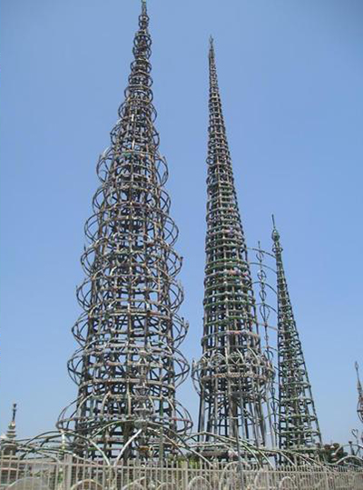
Watts Towers – documentation, restoration, conservation
Planet 9 develops 3D “virtual cities” for architects, engineers, researchers, film producers, game developers and others who need realistic city backdrops, and provides custom 3D modeling, animation, interface design and application development. “Last year we were asked to do what may be the most difficult project we’ve ever done,” Colleen recounts – to create an accurate digital 3D model of Watts Towers.
The towers consist of 17 sculptures built on a residential lot in the Los Angeles community of Watts. The sculptures are constructed from steel pipes and rods, wrapped with wire mesh, coated with mortar, and embedded with pieces of porcelain, tile and glass. Two are nearly 100 feet tall. “Watts Towers was created by an Italian immigrant and tile setter named Simon Rodia” as a tribute to his adopted country, Colleen says. “Each day he’d come home from work with excess tile scraps and mortar, and in his back yard he started building what became Watts Towers.” Using nothing but hand tools and cast-off materials, Rodia worked on the towers from 1921 to 1955. “Then one day he walked away from his house, locked the door, gave the key to his neighbor and never came back.”
Some time afterward “a neighbor realized that this was a wonderful historic landmark and began the process of saving and restoring it,” Colleen continues. The towers were designated a Los Angeles Cultural Heritage Monument in 1963, and “to date the state of California has spent millions of dollars restoring and maintaining the structure as a historic site.” Now a state historic park, Watts Towers is one of only nine works of folk art listed on the National Register of Historic Places, according to the California State Parks system.
Planet 9 was invited into the project by Architectural Resources Group (ARG), a San Francisco-based provider of architectural, planning and materials conservation services hired by the State of California to administer a conservation project for the towers. ARG’s managing partner, David Wessel, describes how the project began. “We were engaged in 2003 by the California State Parks Department to do a conditions assessment of Watts Towers,” he says. “We conducted a complete inspection of the towers using photographs to document areas of deterioration. Then we wrote a report identifying the problems and estimating the costs to repair them.”
“The Parks Department had a peer-review panel review our report,” Wessel continues, “and out of that came a recommendation that the department engage us for two things: one, additional research on repair methods; and two, some way to document the towers.” This broadened the original project scope. “The Parks Department was initially focused on actual repair, not documentation,” Wessel explains. But the peer-review panel, recognizing that “there were already roomfuls of documentation about the towers in various forms,” recommended expanding the project to include “figuring out a way to record the mechanisms of deterioration so we could understand them better.”
Unfortunately the existing documentation did not include any record of the towers’ geometry, Wessel says. That spurred him to bring in Planet 9, because he knew of previous work the company had done creating 3D models as visual interfaces to databases for the U.S. Navy. “The new buzzword for this is BIMs – building information models,” Colleen observes. “The idea is that a 3D model is not just a pretty picture but an interface to data. We’ve worked with the U.S. Navy for ten years building 3D models of naval bases. The models connect to a database of engineering data. The idea is simple – in the 3D model you click on a view of piling, say, and that brings up all the engineering data pertinent to that piling.”
ARG wanted Planet 9 to apply the same approach to Watts Towers for tracking conservation data, Wessel explains – for example, as Colleen puts it, the fact that “a crack in a particular location grew by half an inch over the past year, or that it was repaired with pressure-injected epoxy grout and here are the test results of how that grout performed over the past five years.”
Data collection and modeling work process
Planet 9 reports it contracted with a local firm to capture the towers’ geometry with 3D laser scanning and “produce a mesh of the entire site – a small area, but highly detailed – at a point spacing of one inch or less,” Colleen says. “They had to perform quite a few scans, given the complexity and the severe occlusions made by the structure.” When the firm was unable to process the point-cloud data into a complete, watertight polygonal mesh of the complex geometry, Planet 9 next turned to Dietrich Evans from 3D Laser Imaging (Gilbert, AZ), who reports he also found the task daunting. The scan data he received from Planet 9, he says, “had many different locations where the point clouds looked fine, but when you got closer and tried to grow a unified mesh, the point normals were coming from so many different directions that the software could not grow a complete mesh. I used three software packages: I went through Cyclone, and I even tried to work directly in AutoCAD and SketchUp.” In the end, he says, “I gave Planet 9 a DXF file of the most complete mesh that I could produce, created in Cyclone.”
As a result, says Colleen, “our team had to use the laser scans purely as a reference,” in much the same way they used airborne LiDAR data in Planet 9’s HURT UAV command-and-control project. “We went back to our manual approach of producing 3D Studio MAX geometry from scratch” by importing Evans’s DXF files into 3D Studio MAX, then manually tracing over them.
While less efficient than Colleen would have liked, this approach worked – Wessel reports ARG is very pleased with the outcome. Using Planet 9’s visual 3D front end, “we’re adding to the Access database that the Parks Department had already begun to compile – it contains photographs, drawings, handwritten reports, and so on – and what are emerging are some understandable patterns of deterioration.” Wessel adds that managers in the Parks Department and other public bodies responded positively to the 3D user presentation. “They foresee the work by Planet 9 being used in many other facets of cultural management of the site – for example as a way to engage students who visit the site, and to show the public how well the site is being taken care of. The repair history will be available to the public through this model – the Parks Department is looking at putting the model and database on the Web.”


