

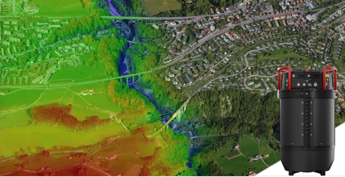
This week at HxGN LIVE Global 2023, Hexagon’s annual digital reality conference in Las Vegas, Nevada, Leica Geosystems, part of Hexagon, introduced their new Leica CountryMapper, a hybrid large-area aerial imagery and lidar mapping solution. The CountryMapper combines a large-format photogrammetric camera with Leica’s lidar sensors into a single unit to allow both imagery and lidar collection simultaneously, reducing the amount of time needed to collect key geospatial data.
John Welter, Division President of Geospatial Content Solutions at Hexagon Geosystems, spoke with media this week and relayed that this development, which builds off of Leica's CityMapper, was made possible by the company’s expertise in both imagery and lidar sensors. The CountryMapper includes the Leico MFC150 camera modules, which utilizes forward-motion-compensation in order to provide high-quality imagery even at high speeds in an aircraft, along with their new Hyperion3 lidar system. Additionally, the CountryMapper supports a full end-to-end workflow with integration with Leica HxMap for processing the imagery and point clouds.
Welter explains that one of the goals of this new aerial mapping system is to provide a path towards relatively widespread adoption, with the CountryMapper able to fit in any standard aircraft. He further explained that this specifically was one of the key processes in the engineering process, with teams from the lidar and imagery sides having to collaborate in order to ensure they did not exceed what their goal was for the size of the unit. He also noted that right now, the time to process the data is a bit under twice the time of flight, but pointed out that they are progressing towards getting that time down to time of flight, which is a goal for all of their products.
As alluded to above, one of the reasons why Hexagon and Leica Geosystems was able to provide this kind of single-unit hybrid data collector is due to the company’s expertise in both imagery and lidar. Welter acknowledged that they have strong competitors on both sides of that coin, but what makes the company unique is their expertise in both areas, which they have been able to leverage in order to create this kind of product. Asked what key technological advancements allowed for this kind of development, Welter pointed to the miniaturization of lidar sensors made with products like the BLK laser scanning line. Without that type of advancement, being able to fit both sensor types into a single unit which can fit into any typical aircraft used for these types of missions would not be possible.
The benefits of a hybrid solution are pretty clear, and come on two fronts, both stemming from the simple fact that with this type of offering only one flight is necessary versus two. For one thing, that clearly cuts down on costs, halving the necessary man hours and fuel needed to collect the desired data. Additionally, speaking to one of the major themes of this year’s HxGN LIVE Global, the CountryMapper also helps address sustainability concerns. While often necessary to collect crucial geospatial data, flying these aircrafts – like any other aircraft – is harmful towards the environment. So, it stands to reason that any way to reduce those flight times will improve an organization’s ESG standing.
In their official release of the news, Hexagon points to orthophoto generation, terrain mapping, hydrography, forestry monitoring and infrastructure management as applications which can benefit from the CountryMapper. Welter also points to the possibility of areas on the globe that aren’t mapped as well as the Western World as benefitting from the product. Specifically, he talks about areas like Africa, South America, and India as regions which could benefit. He points to the company’s relationship with mapping agencies all around the world, with which they work in the development of these products so they are able to use it when it’s released.
Additionally, in talking about usage by these underserved parts of the world, he called out both the simplicity of use, noting that if a user is familiar with other systems besides the CountryMapper will still feel familiar, as well as the company’s vast network of partners and support staff all around the globe for local assistance if needed.
In a press statement, Layton Hobbs, Airborne Product Line Director at Hexagon, summed up the CountryMapper’s value by saying, “Airborne data providers have had to tailor their LiDAR and imaging offerings to emphasize one or the other. The CountryMapper provides both at the highest performance levels in a single system configuration.”


