

In modern practice the constant motion of the surface of the Earth cannot be ignored. In light of stringent absolute accuracy specifications the epoch (i.e. 2010.00) of the reference frame (i.e. ITRF2014) must be considered.
The movement of the tectonic plates, ocean and atmospheric loading, Earth and polar tides stipulate that a viable global terrestrial reference frame must contend with the velocity of its control stations. The International Terrestrial Reference Frame (ITRF) is maintained by the International Earth Rotation Service (IERS), which monitors Earth Orientation Parameters (EOP) through the hundreds of stations in its global network. The data from these stations provides the basis for the calculation of the linear velocities of ITRF stations on the approximately 20 tectonic plates worldwide. The weighted combination of the most recent observations from several analysis-center solutions around the globe inform the regular re-estimation and updating of the ITRF. Those updates are labeled with the last two digits from the year’s data used in the realization (i.e. ITRFyy). The first ITRF in 1988, the ITRF88 network, was derived from observations at about 100 sites with single instrumentation and 22 co-locations The observations for the ITRF08 realization were performed at 580 sites and 100 co-locations. A co-location is a site where two or more instruments are in close proximity.
One of them, the Grasse co-location, is on the Eurasian plate at 10 km north of Grasse and 30 km west of Nice. It is hosted by “Observatoire de la Côte d’Azur” (OCA) and incorporates three geodetic measurement systems.
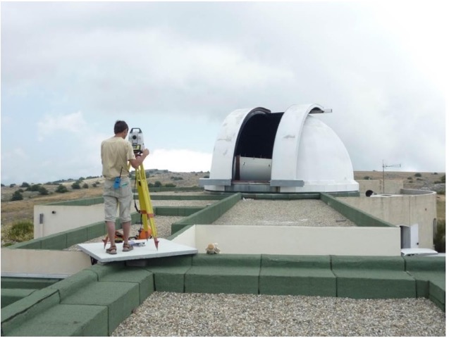
Its Laser Ranging system includes two ranging stations. One of them is called GRSM, a 154 cm aperture telescope, and the other is GRAF, a mobile Laser station. There is one Doppler Orbitography and Radiopositioning Integrated by Satellite (DORIS) station named GR4B, and one Very Long Baseline Interferometry (VLBI) reference point. The Global Navigation Satellite System (GNSS) at the site consists of two permanent International GNSS Service stations about 32 m apart GRAC and GRAS. This is the GRAS GNSS antenna.
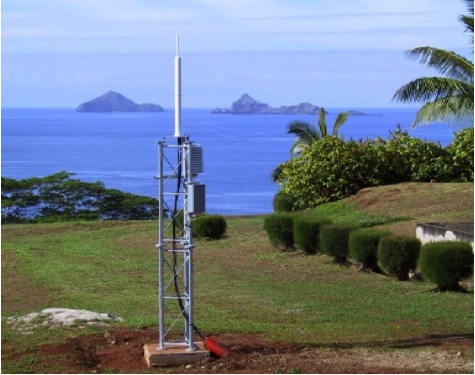
Despite its appearance of permanence GRAS is on the move as is everyone point on the planet. Here is a calculation of how far it has gone since 2010. This was its position in ITRF2014 at the moment of midnight on January 1, 2010 (2010.00) in Earth-Centered-Earth-Fixed XYZ coordinates (meters);
- X = 4581690.8306
- Y = 556114.9301
- Z = 4389360.8511
in latitude and longitude in decimal degrees 43.75469971, 6.92059994 and in degrees, minutes and seconds N43 45 16.91896, E06 55 14.15978. The ellipsoidal height is 1319.308m
Here are the velocities of GRAS in meters per year;
- X = – 0.01377 m/yr
- Y = + 0.018869 m/yr
- Z = + 0.011415 m/yr
Therefore, by February 10, 2019 (2019.11) GRAS had moved this far from its position on January 1, 2010:
- X = – 0.01377 x 9.11 = – 0.1254 m
- Y = + 0.018869 x 9.11 = + 0.1719 m
- Z = + 0.011415 x 9.11 = + 0.1040 m
Adding these shifts to GRAS’s 2010.00 position the coordinates at that moment in time are:
- X = 4581690.8306 – 0.1254 = 4581690.7052
- Y = 556114.9301 + 0.1719 = 556115.1020
- Z = 4389360.8511 + 0.1040 = 4389360.9551
Here was the position of GRAS in ITRF2014 at the moment of midnight on February 10, 2019 (2019.11):
- X = 4581690.7052
- Y = 556115.1020
- Z = 4389360.9551
in latitude and longitude in decimal degrees 43.75473986, 6.92057681 and in degrees, minutes and seconds N43 45 17.06349, E06 55 14.07650. The ellipsoidal height is 1319.305m
In 9 years GRAS moved N52degreesE 0.24m (0.8ft) and down 0.003m (0.01ft)
Differentially correcting a GNSS collection of a point of interest likely uses data from a base station like GRAS. The position derived from the process is correct for the bases position at the epoch, the moment in time its coordinate and height were established. That moment will certainly be in the past. Therefore, the resulting position of the point of interest will be where it was at that epoch in the past too. Since that time both the base and the point of interest have literally moved away from their coordinates. Nevertheless, such data are routinely archived in large data stores which raises the question, “How should such constant shifting be handled?” Part of the answer is that each positional record in a data store should include that records reference frame and epoch. In other words, the records should show not only where they were, but also when they were there.
When a specification for horizontal absolute accuracy stipulates that results must be within a limit such as +/-0.24 (0.8ft) @ 99.7% the reference frame and epoch should be included in the delivery. Should it be followed by a time period during which the data remains valid? How about, “The delivery is in ITRF2014 (2019.11) and the positions reported will remain within the horizontal absolute accuracy specification until March 21, 2028 [ITRF2014 (2028.22)]”? That seems cumbersome, but if not that how will the user be kept aware of such a shelf life? Perhaps the data store needs to include more than the reference frame and epoch. Maybe the velocities of each of the geospatial records are also needed. If these data, reference frame, epoch and velocities were all stored together it would be possible for the implementation of a watcher that could through a flag when a record was about to go out of spec or invoke a routine that updates it.
The combination of dramatic improvements in our ability to measure, storage of geospatial information in larger and larger data stores and the increases in the accuracy reference frame definitions have made the issue of tectonic movement unavoidable. In more and more areas of practice it is no longer adequate to know only where, it is vital to also know when.


