As you may remember, back in 2012 I wrote a column about field-testing P3dSystems’ first kinematic scanner, the ProScan G101. Last week, I had the pleasure of spending time in the field with Daniel Omelanowsky, an application engineer at P3dSystems while we put the ProScan’s latest module, the T-Series, through its paces. How did it fare?
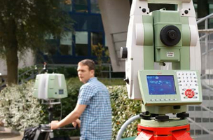
Given that a couple of years have passed, I should probably start with a refresher. P3dSystems created the ProScan as a kinematic laser scanning system. It uses an IMU and GPS for positioning and tracking. You mount a laser scanner on the rig (it currently supports Leica HDS6100, HDS6200, HDS7000, P20; Z+F 5006, 5010) and walk it around, controlling the entire unit through P3dSystems’ PScan software, which comes preloaded on a Microsoft Surface tablet.
Now for the changes. Previously, I referred to the system as the G101, or the ProScan G101. Since I wrote my last column, P3dSystems has rebranded the hardware as the ProScan and launched multiple modules within the PScan software suite. What was the G101 is now the G-Series module.
The difference between the modules lies in how the tracking is accomplished. The G-Series tracks using GPS (as I noted above), the I-Series uses inertial information (zero velocity periods on the trajectory at known intervals), and the T-Series uses a Total Station. I spent this last week working with the T-Series.
The T-series was designed to allow for two things that were lacking in the G-Series: sub-centimeter accuracy and the ability to work indoors. The T-Series accomplishes these by replacing the GPS antenna with a 360° prism and tracking the unit with a robotic total station. For the record, P3d recommends a 1-second gun but they say that a 3-second gun will suffice. We actually used a 5-second gun last week and I found the results to be as good or better than static scans performed with the same scanner (Z+F 5010c). I came away quite impressed by the results.
However, there are a few things to note about the T-Series. It is a lot to manage at one time. You have to plan out your “tracks” (the routes that you plan to scan). You have to create survey control points with the total station that allow visibility between the ProScan and the total station throughout the length of the track. You also have to master the field technique necessary for collecting a dataset. This last bit, the field technique, seems to be where things are most likely to go wrong.
Because it is a profiling scanner, the first technique you need to learn is how to offset the profile so that it scans at a 45° angle to the trajectory. Then, when you turn around for a return pass, you need to flip the 45° angle to the opposite side in order to cover all surface faces. It sounds simple but it takes some practice.
Next, you need to master the pace of travel. The best practice is a walking speed of 0.3m per second (1 ft/s). However, you have to include zero velocity moments as well. You travel for 8 seconds, then pause for 3 seconds, leaving the system at zero velocity. It is important to note that these pauses must occur when there is a clear line of sight between the ProScan and the total station. This checkpoint is used by the software to account for the level of drift picked up by the IMU at the present location. The software’s algorithm isolates these zero velocity moments from the rest of the track to calculate the drift and control for this drift during the entire track.
Lastly, there is the need to maintain visibility between the ProScan’s prism and the total station. However, you can lose lock without it causing a problem if you continue moving along the same line before and after the loss of visibility, assuming that the time in the blind spot was short. The best results for dealing with a bling spot seemed to come from creating a zero velocity moment just before losing line of sight then making a straight line to the next point where visibility is restored, and then creating another zero velocity moment.
All of this has the effect of changing my mindset when it comes to field collection. Typically, I have a clock in my head that starts to send alarms if I am onsite too long before I start collecting data. Every moment not scanning is a wasted moment! However, with the T-Series you spend almost all of your time planning the scan, while the scanning takes very little time. During our work last week we averaged something close to 2 kph (1.2 mph) average scan speed. On the clock, that means an hour planning and setting the total station up, then a 22-minute collection track with a length of 0.9km (0.5 miles).
One of the largest improvements since my last field test is in the reports that are auto-generated by the PCloud software. With one or two pages, users can assess the accuracy of the track, see everywhere they lost lock with the total station, each time there was a zero velocity moment, and more. These are exceedingly helpful and a vast improvement over simply spot checking the data.
I was quite impressed with the T-Series, but it’s not the perfect use case for everything. Due to the setup time, it is sometimes faster to perform a static scan. But for larger areas (manufacturing facilities, warehouses, airports, construction sites, etc.) I’ve seen nothing that can touch its level of productivity and accuracy.