The ease of setting project control today can obscure the importance of keeping some rules of network design in mind. Here are a couple that might be useful.
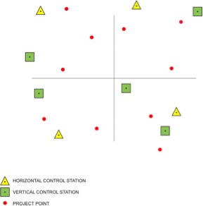
The location of control stations, relative to the project itself, is an important consideration in choosing horizontal control. For work other than route surveys, a handy rule of thumb is to divide the project into four quadrants and to choose at least one horizontal control station in each. The actual survey should have at least one horizontal control station in three of the four quadrants. Each of them ought to be as near as possible to the project boundary. Supplementary control in the interior of the network can then be used to add more stability to the network.
At a minimum route surveys require horizontal control at the beginning, the end, and the middle. Long routes should be bridged with control on both sides of the line at appropriate intervals. The standard symbol for indicating horizontal control on the project map is a triangle.
Vertical Control
Those stations with an accuracy high enough for consideration as vertical control are symbolized by an open square or circle on the map. Those stations that are sufficient for both horizontal and vertical control are particularly helpful and are designated by a combination of the triangle and square.
A minimum of four vertical control stations are needed to anchor a network. A large project should have more. In general, the more benchmarks available the better. Vertical control is best located at the four corners of a project.
Orthometric elevations are best transferred by means of classic spirit leveling, such work should be built into the project plan when it is necessary. When spirit levels are planned to provide vertical control positions, special care may be necessary to ensure that the precision of such conventional work is as consistent as possible with the rest of the survey. Route surveys require vertical control at the beginning and the end. They should be bridged with benchmarks on both sides of the line at intervals from 5 to 10 km.
When the distances involved are too long for spirit leveling to be used effectively, two independent GPS measurements may suffice to connect a benchmark to the project. However, it is important to recall the difference between the ellipsoidal heights available from a GPS observation and the orthometric elevations yielded by a level circuit.