
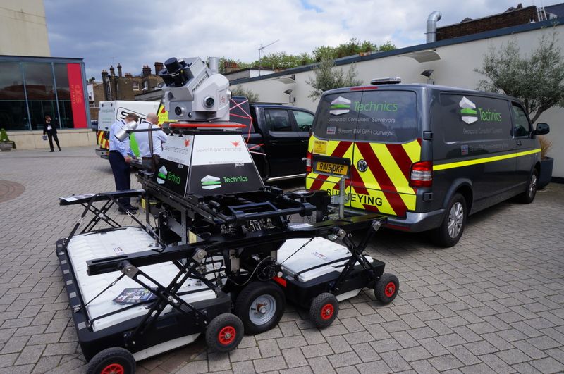
I was immensely–and very happily–surprised at the Geo Business 2016 conference in London when I spotted a towable combined above ground/below ground scanner on the street outside the conference. This configuration, which combines a mobile laser scanner with a ground penetrating radar (GPR) array, was designed to survey once and cover above and below ground simultaneously. To me, it signals that underground utility mapping is beginning to attract the interest of major survey equipment vendors. Taken with the Open Geospatial Consortium’s recent initiative to develop interoperability standards for underground infrastructure, this represents a significant new advance in mapping underground utilities.
This article is intended as a follow-on to the article “Accelerating world wide initiatives to map underground utilities” I published several years ago.
Why This Matters
About 4 million excavations are carried out on the UK road network each year to install or repair buried utility pipes and cables. Not knowing the location of buried assets causes practical problems that increase costs and delay projects but, more importantly, it increases the risk of injury for utility owners, contractors, and road users.
The problems associated with inaccurately located buried pipes and cables are serious, and are rapidly worsening due to the increasing density of underground infrastructure in major urban areas. In the U.S., it is estimated that an underground utility is hit about every minute. Underground utility conflicts and relocations are the number one cause for project delays during road construction. Assuming the average direct cost of underground strikes is roughly $1000 per strike, the estimated total cost to the U.S. economy is $1.5 trillion annually. If indirect costs such as traffic disruption, project schedule delays, and others are included, the economic cost is significantly higher.
Dr. Nicole Metje of the University of Birmingham has researched the direct costs of utility strikes in the U.K. The figures are listed in the table below.
| Electricity | £ 970 |
| Gas | £ 485 |
| Telecom | £ 400 |
| Fibre-optic | £ 2,800 |
| Water | £ 300-980 |
Direct costs include the costs of sending a crew to assess and repair the damaged pipe or cable. Indirect costs include the impact of traffic disrupted by the strike, injuries, and other impacts on the health of the workers directly involved (or people in the immediate neighborhood), and the lost custom that businesses experience as a result of the traffic disruption. By accounting for these indirect costs, Dr. Metje has found that the true cost associated with utility strikes is much higher than the direct costs. She estimates that the true cost is about 30 times the direct cost.
A number of return on investment (ROI) studies have identified the significant benefits of knowing where underground utilities are located. A USDOT-sponsored survey conducted by Purdue University in 1999 quantified a total of US $4.62 in avoided costs for every US $1.00 spent on accurately locating underground utilities. Although qualitative savings (for example, avoided impacts on nearby homes and businesses) were not directly measurable, the researchers believed those savings were significant, and arguably many times larger than the quantifiable savings.
A Pennsylvania State University study commissioned by the Pennsylvania DoT found a return on investment of US $21.00 saved for every US $1.00 spent on elevating the quality level of subsurface utility information. An economic analysis of the costs and benefits of applying GPR to detect the location of underground infrastructure in in Lombardy, Italy estimated that the return on investment is about €16 for every euro invested in improving the reliability information of underground infrastructure.
New standards initiative for underground utilities
Standards for reporting the reliability of the locational information about underground utilities have been in place for decades, but there have been recent developments that reflect improvements in underground remote sensing technology. The new PAS 256 standard “Buried services – Collection, recording and sharing of location information data” which is intended to complement the existing PAS 128 standard was released in April of this year.
Currently, the exchange of underground utility information between infrastructure organizations within the same jurisdiction or in adjacent jurisdictions has been greatly hampered by incompatible and incomplete data. The Open Geospatial Consortium (OGC) has initiated a three-phase project to develop interoperability standards for underground infrastructure. The Underground Infrastructure CDS project is supported by the Fund for the City of New York and its sister organization, the National Center for Civic Innovation, the Ordnance Survey and other organizations.
Check back next week for the next installment covering the present and future technology of underground utility mapping.


