

I have had the privilege and in most cases the pleasure of working with most every major 3D laser scanner on the market over the past decade. Despite knowing John Dolan of Maptek for most of that time, the I-Site scanners remained a blight on my record. I think that the fact that Maptek markets themselves so heavily toward mining has something to do with this, but to be perfectly honest I had always viewed them as sacrificing accuracy for range. Not necessarily a bad choice, just one that did not align itself with my client base.
Earlier this spring, I finally had the chance to use an I-Site 8800 in the field thanks to Chris Little of Maptek Australia. We were capturing a racetrack for a video game developer and for once the accuracy required was in the high centimeter range as opposed to millimeters. I had not planned on using the 8800 but three mornings of heavy fog along with an aggressive track grade put us a bit behind schedule. In the end I was extremely happy to see Chris and the 8800 on-site!
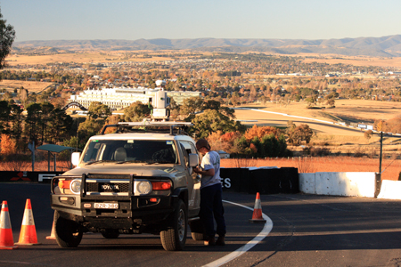
The rig consisted of an I-site 8800 (also sold as the Leica HDS8800) mounted on the roof rack of a Toyota FJ Cruiser. The unit is controlled by a Toshiba tablet PC running Maptek I-Site Studio. There is an internal camera for RGB capture and most of the settings for point density are easily selected via menu presets. For this application we used a GPS/RTK unit and took a shot on top of the scanhead and then another on the bull bar of the cruiser. By locating that same spot on the bulbar in the point cloud you assign your back sight position and thus roughly geo-locate each scan. I was concerned that such a short baseline would cause accuracy issues but Chris assured me they could be resolved through post-processing.
I only got about 10 days with their office software package (I-Site Studio 3.5.1) but the work flow is quite a bit different from the Leica Cyclone package that I use most often. I was not able to produce registered datasets with the level of accuracy that Chris was able to achieve, but I did find the user menu to be very helpful (with the exception of noting that selections for “drag & drop” functionality require the scroll wheel button!). The application allows for most of the standard export formats (no PTX or e57) and has a wizard for creating custom export fields for ASCII files.
Overall I liked the system a lot. The negatives are few ($250,000 price tag, lack of 3D view during scanning with tablet) with quite a few positives. The added range was fantastic, but the biggest benefit from this range increase was the high intensity return on black asphalt. The work flow in the field was very familiar to anyone that has done any land surveying and fairly quick given the vehicle mount. While Chris achieved a good registration, if I found myself using the system again I would set the back sight up with a much longer baseline to increase the accuracy of the initial registration. I really like some of the visualization tools like being able to automatically assign random colors to each point cloud during registration. This makes spotting misalignment much easier. I also liked the way that you could select minimum and maximum ranges (relative to each scanner position) to be used in cloud to cloud registration calculations. If you get a chance to play with one of the 8800s, I would definitely take the time to do so. I’m of the opinion that every scanner gains some attribute at the expense of another. We all bought/rented/borrowed the scanner we have with the idea that it hit that sweet spot in terms of attributes that best fit our needs.
However, it’s nice to try on someone else’s idea of that sweet spot on occasion!


