
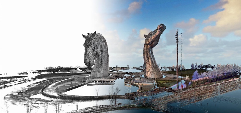
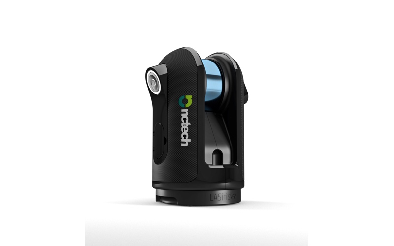
NCTech is on hand at SPAR 3D this year demonstrating its LASiris VR, a system that integrates a 120 megapixel HDR camera and a 100-meter range lidar sensor with 30 mm accuracy. The system is much talked-about because NCTech is not marketing it as a lidar scanner, but instead a “3D reality capture camera” that seamlessly blends 360° color imaging with point clouds. (Read SPAR’s original story for more details on the device).
Ahead of SPAR, I caught up with NCTech CEO Cameron Ure to ask the questions on everyone’s mind. We talked VR tech, the best way to open new 3D markets, and who exactly this new sensor is for.
Sean Higgins: I see you’re marketing the product as a “3D Reality Capture Camera,” which seems to indicate that the lidar in the system is secondary. In fact, I don’t think you mention the word “lidar” anywhere on the product page. Is this by design?
Cameron Ure: There are a couple of reasons for this. Within the GIS and AEC markets, users tend to be highly technical and very familiar with terminology like “lidar.” These markets and other traditional users of terrestrial laser scanners will certainly have plenty of interest in LASiris VR, and we have seen a lot of excitement build already. However, our focus and motivation to build this product was much broader.
LASiris VR was developed to democratize VR. To us this means both contributing to existing VR markets, so providing simple-to-use solutions to capture real-world spaces for high quality visualization with dimension and scale. We are also bringing some of the exciting things happening in the VR space into more technical markets, emphasizing ease of capture for user created content with strong visual elements, rather than chasing additional millimeters or microns accuracy – areas already very well served by survey or metrology grade instrumentation providers.
The laser scanner doesn’t offer the highest accuracy available—is this because the device is intended to be used primarily for visualization?
 There is certainly an emphasis on visualisation with dimension and scale rather than pure measurement. However, there will certainly also be some applications where we can deliver the required measurement accuracy also, things like stockpile volume calculations, crime and accident site documentation and other public safety uses.
Within the SPAR 3D community, we frequently see people using highly accurate ‘survey grade’ scanning systems for projects that just don’t need the level of point precision they inherently get from these devices. Frequently the output of most value to these users is the detailed HDR imaging, which of course is what we been providing with iSTAR.
We think there is an unmet demand in the market for a tool that flips the prioritization of these output elements. Great imaging and simple to use for the less-technical workforce, combined with 3D capture capability for virtual visualization with scale and dimension of the real world environment being captured. If you consider the lifecycle of a building as an example, there are many points where this is of real value:
- Pre-build/conversion where the asset owner can now simply capture the as-built conditions facilitating a more efficient bid process.
- Improved visualisations for blending with the new design renderings for improved design decisions and planning approval outcomes.
- During the construction process to more efficiently and thoroughly document each build phase for contract compliance and claims.
- Post completion, for site maintenance and asset management, right through to end of life demolition planning or re-purposing.
Can you tell me how the registration process works?
LASiris VR will be introduced with its own automatic cloud-to-cloud registration but since we emphasize data neutrality, our scans can also be taken into other platforms where other specific functions and processes, such as more advanced registration tools can be used.
We will be incorporating ColourCloud into our Immersive Studio software platform for processing of LASiris VR data. Last year at SPAR 3D we were heavily promoting our open integration philosophy and this will continue with LASiris VR. The Immersive Studio SDK will be freely available for third-party platform owners to be able to integrate with. This means easy read-in of our native raw data for all our clever processing algorithms to run behind the third-party software, reducing a processing step which is always of interest to users.


