
It’s no secret that I love lidar. Laser scanning is and has been the single best way to fully tell a story. Laser scanning has been the king of reality capture because nothing else has been able to equally capture the look of an environment with the accuracy of a survey. However, there are some new technologies that are challenging laser scanning for its crown. This young upstart is poised to revolutionize how we visualize, analyze, and interact with 3D spatial data. Let me introduce Gaussian Splats.
Imagine a world where survey data transcends the limitations of traditional point clouds, transforming into a vibrant, interactive 3D model teeming with realistic lighting, textures, and immersive detail. This is the promise of Gaussian Splatting, a cutting-edge technique that represents 3D scenes as a collection of “splats” – colorful, fuzzy points in space, each mathematically defined as a 3D Gaussian function. These splats encode not only a point’s position but also its color, size, normal orientation, and even how it interacts with light, resulting in incredibly detailed and visually compelling 3D models.
The Mechanics of Gaussian Splats
Unlike traditional point clouds, which merely represent a collection of individual points in space, Gaussian Splats offer a more nuanced and efficient approach to 3D scene representation. Here are some of the primary mechanics that make this technology tick:
- Image-based Creation: Gaussian Splats are often generated from a series of images captured from various angles around a scene. Sophisticated algorithms meticulously analyze these images, identifying corresponding points and extracting their 3D positions, colors, surface normals, and other relevant attributes. This process effectively transforms 2D images into a rich and comprehensive 3D representation, capturing the essence of the scene with remarkable fidelity.
- Compact and Efficient: One of the most compelling advantages of Gaussian Splatting lies in its efficient data representation. Compared to traditional point clouds, which can result in massive file sizes, especially for large-scale surveys or complex environments, Gaussian Splats achieve a similar level of detail with a significantly smaller storage footprint. This compactness makes them easier to handle, process, transmit, and store, particularly in scenarios with limited bandwidth, storage capacity, or computational resources.
- Photorealistic Rendering: Gaussian Splats excel at producing photorealistic renderings of 3D scenes. By incorporating information about how light interacts with each point – its reflectance properties, surface normals, and even subsurface scattering – they can accurately simulate a wide range of visual effects, including reflections, shadows, and subtle variations in material appearance. This results in visually stunning and immersive experiences that closely resemble real-world observations.
- View-Dependent Appearance: A remarkable feature that sets Gaussian Splatting apart is their ability to capture view-dependent effects. This means that the appearance of objects changes subtly depending on the viewing angle, just as it does in reality. This nuanced representation adds another layer of realism to the 3D models, making them more engaging, believable, and lifelike.
Gaussian Splats in Surveying
While still in its early stages of development and adoption, Gaussian Splatting holds real potential to transform the field of surveying and geomatics.
- Enhanced Visualization and Communication: Imagine presenting survey data not as a dense and abstract cloud of points but as a photorealistic 3D model that clients can intuitively explore and interact with. This could revolutionize how surveyors communicate their findings, making it easier for stakeholders to understand, visualize, and engage with complex spatial information. This enhanced visualization could be invaluable for presentations, design reviews, and public consultations, fostering a deeper understanding and appreciation of the surveyed environment.
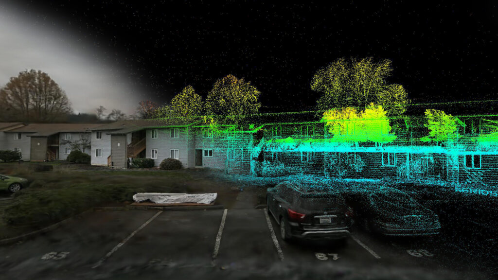
- Complementing Lidar: Gaussian Splatting and lidar can work synergistically, leveraging their respective strengths to create a more comprehensive and informative representation of the surveyed area. While lidar excels at providing highly accurate 3D measurements and capturing fine geometric details, Gaussian Splatting can enrich the point cloud with color, texture, and visual richness, creating a more holistic and engaging representation. This fusion of data could lead to more accurate and informative surveys, particularly in applications where visual details are crucial, such as heritage documentation, environmental monitoring, and urban planning.

- XGRIDS Leading the Way: Companies like XGRIDS are at the forefront of this convergence, developing cutting-edge lidar devices like the Lixel series that are specifically designed to generate Gaussian Splats. These devices integrate lidar scanning with real-time Gaussian Splat creation, capturing both the precise geometry and the visual richness of the scene, simultaneously. This integrated approach streamlines the data acquisition process and opens up new possibilities for surveyors to capture and represent the world in unprecedented detail.
- Immersive Virtual Tours: Gaussian Splats can enable the creation of immersive virtual tours of surveyed sites, allowing clients and stakeholders to experience a location remotely, navigating through the 3D model as if they were physically present. This capability can be invaluable for planning, design, and decision-making, especially for projects involving remote or inaccessible locations, hazardous environments, or sensitive sites where physical access is restricted. Virtual tours can also facilitate collaborative design reviews, enabling stakeholders to explore and discuss the site from different perspectives and contribute to the decision-making process more effectively.
- Efficient Data Management and Collaboration: The compact nature of Gaussian Splats offers significant advantages for managing, sharing, and collaborating on large survey datasets. Their reduced storage footprint can streamline workflows, reduce storage costs, and facilitate seamless data exchange between project teams, even in bandwidth-constrained environments. This enhanced efficiency can lead to faster turnaround times, improved collaboration, and more cost-effective project delivery.
Navigating the Future Challenges
Despite their immense potential, Gaussian Splats face certain challenges in the context of surveying and geomatics. Here are some key areas where further research and development are needed:
- Accuracy and Precision: While constantly improving, the accuracy and precision of Gaussian Splats for high-precision measurements may not yet match that of well-established techniques like lidar, especially in demanding surveying applications where millimeter-level accuracy is critical. Further research is needed to refine the algorithms and techniques used to generate Gaussian Splats, ensuring they meet the stringent accuracy requirements of surveying and mapping.
- Computational Demands: Generating Gaussian Splats from images can be computationally intensive, requiring powerful hardware and optimized algorithms to process large datasets efficiently. As technology advances and computational resources become more accessible and affordable, this challenge is likely to diminish. However, ongoing research into more efficient algorithms and hardware acceleration techniques will be crucial for wider adoption in surveying.
- Data Acquisition and Processing: Acquiring suitable image data for surveying purposes can be challenging, requiring careful planning and execution to ensure proper coverage, lighting conditions, and image quality. Additionally, processing the acquired images to generate accurate and reliable Gaussian Splats can be complex and time-consuming, requiring specialized software and expertise. Developing more streamlined and automated data acquisition and processing workflows will be essential for wider adoption in surveying.
The future of Gaussian Splats in surveying is brimming with possibilities. Ongoing research and development efforts are focused on:
- Improving Accuracy and Precision: Researchers are actively developing new algorithms and techniques to enhance the accuracy and precision of Gaussian Splats, pushing their capabilities closer to those of lidar and other high-precision surveying techniques. This includes exploring novel approaches to data acquisition, processing, and optimization, as well as leveraging advancements in machine learning and computer vision to improve the accuracy and reliability of Gaussian Splat generation.
- Seamless Integration with Existing Workflows: Software developers are working on integrating Gaussian Splats into existing surveying workflows, making it easier for surveyors to adopt and utilize this technology without disrupting their established practices. This includes developing plugins and extensions for popular surveying software packages, as well as creating dedicated tools for visualizing, analyzing, and manipulating Gaussian Splat data.
- Real-time Applications: Imagine surveyors creating 3D models of a site in real-time as they collect data, using drones, mobile devices, or other portable sensors equipped with Gaussian Splat generation capabilities. This could revolutionize fieldwork, providing immediate feedback, facilitating on-site decision-making, and enabling rapid response to changing conditions. Real-time Gaussian Splat generation could also be invaluable for monitoring dynamic environments, such as construction sites, disaster areas, and evolving landscapes.
Conclusion
Gaussian Splats represent a significant leap forward in 3D scene representation, offering a compelling alternative to traditional point clouds with a unique blend of compactness, efficiency, and visual fidelity. Their ability to capture the nuances of real-world appearance, combined with their efficient data representation and rendering capabilities, makes them a powerful tool for a wide range of applications, including surveying, mapping, visualization, and virtual reality.
While challenges remain in terms of accuracy, computational demands, and data acquisition, ongoing research and development are paving the way for Gaussian Splats to become an indispensable part of the surveyor’s toolkit. Indeed, the true power of this technology may lie in its synergy with existing techniques. The convergence of lidar and Gaussian Splats, as exemplified by innovative companies like Xgrids, represents a blending of the best of both worlds: the accuracy and precision of lidar combined with the visual richness and efficiency of Gaussian Splats. This powerful combination promises to unlock new levels of detail, realism, and efficiency in how we capture, represent, and interact with the three-dimensional world.
As this technology matures and becomes more accessible, we can expect to see a profound transformation in how we capture, represent, and interact with the three-dimensional world, ushering in a new era of enhanced visualization, data management, and stakeholder engagement in the field of surveying and beyond.


