I’ve spent most of the last 15 years of my life capturing reality in order to make an accurate digital copy. While our systems for doing this are far from perfect, they are productive and (thankfully) require far less active problem solving than in years past. I’m also happy to say that I have more clients than ever before that are capable of working with, and are practiced at leveraging, reality capture data to their advantage. This increased level of familiarity has led to a reliance on this data.
I am one of those people that can’t let a good slogan go to waste. Autodesk’s “Capture, Compute, Create” has long been a favorite of mine and I’m sure I’ve parroted it to every client I have. I started as a land surveyor, which is mostly “Capture” with a bit of “Create” thrown in. As I kept up with advances in lidar technology, I found myself performing more and more of the “Create” functions for clients. So what’s my problem? Clients now want me to help them with the “Create” part!
The problems with “Create”
Technically, this is not a problem. As a land surveyor, I work in known coordinate systems whenever possible and I learned to perform stakeouts/layouts before I knew what a laser scanner was. Showing where a perfectly designed 3D model of an asset should reside in reality should be a piece of cake. Add to that the remarkable number of new tools that allow technicians to work directly with the 3D model, or even the BIM, while performing stakeout functions, and one would suspect that this would be an increasing market vertical for us all. So, why are so many of us reluctant to do it? In a word: liability.
To be clear, I am immensely confident in my ability to connect my BIM and the actual site, as well as demonstrate the connections during any and all phases of construction. So why am I worried about being liable for it? Well, not only will I give you a reason, I’ll give you three.
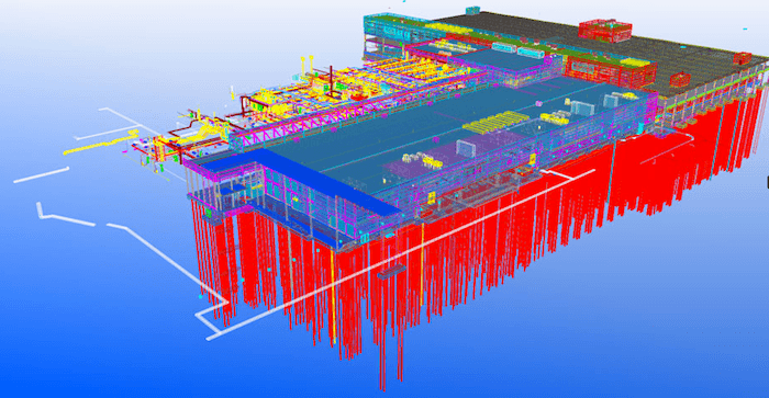
A Hovermap scan of a construction project in progress
1. How Construction Contractors Use My Data
Have you ever watched the construction take place after you staked something out? It is typically undertaken by a crew that has a completely different understanding of the term “accurate.” To be clear, there are exceptions and, in fact, there are entire specialties that are exceedingly good at accurate construction. But these are not the majority of the people building our commercial structures all over the world today. By definition, the act of construction will destroy or at least obscure your marked locations. There are few things more frustrating than fretting over millimeters while setting a point only to watch someone come behind you, take a saw and cut out that piece of concrete so that they can install the asset you located for them! I could go on for days with examples but the reality of the situation is that the vast majority of construction trades do not adhere to, and are not required to adhere to, the accuracy standards applied to reality capture technologies. So, why should I sign up to take on the liability of millimeter accuracy for a guy building at centimeter accuracy?
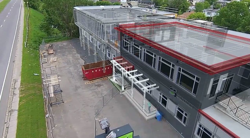
A Bentley experiment to overlay an as-built mesh with a BIM in augmented reality.
2. The Lack of As-built Documentation
Obviously, we are not being asked to lay out everything in the BIM. While this is completely understandable, it also means that the relationship of assets in the BIM that were staked out versus those that were not may be in conflict. That distinction is not always abundantly clear when a conflict is discovered by a general contractor. Like the one that wanted me to layout steel post anchor bolts on the floor (that they had cracked by using a piece of equipment on it that was too heavy). It was a known issue and they were going to have to repair later by floating a new surface (this repaired, higher elevation surface was already in the BIM). I explained that this meant that his location in the Z (elevation) would not be accurate, as I didn’t know of a way to leave a mark in thin air. I offered to mark the correct location (X & Y) on the floor as long as we had a change order noting the difference in that approach versus our contractually obligated approach. That conversation didn’t go well. Another time I was called in because my layout marks caused a firewall to intersect with a HVAC trunk. The client supplied Revit model did not include the HVAC data. I’m still not sure how I got blamed for that one. Lastly, there are the numerous projects where I show up to perform a layout only to find that the structural model is so inaccurate due to being created by “a few measurements on each floor” that points derived in the BIM are simply not applicable to reality.
 3. The Market Rate for Stakeout (Layout) Services
While onsite, the client sees a standard survey crew and that is the rate they expect to pay. While the subject of what that rate should be is an entire other article, we should be honest about the fact that, while we may be using the same hardware as a standard survey crew, we are being asked to do very different things. When performing lot layout or traditional surveys, the accuracies are less stringent and there are decades of best practices that all trades fall back upon when undertaking construction. Performing BIM layout is an exercise in creating best practices for many. In essence, the latter task requires a lot more time and effort than the former. Additionally, one has to look at the project as a whole. Many times you are looking at a couple of thousand dollars in service fees, along with liability for construction errors that can be millions of dollars. In some cases the financial calculus leaves you unable to charge enough to account for the risk.
In conclusion
So, where does that leave those of us espousing the Capture, Compute, Create ethos? Hopefully, right where we are accustomed to being; ahead of the curve. The promise of reality capture in the built environment will only be fully realized when we are able to hold our higher levels of accuracy all of the way through the Capture, Compute, Create lifecycle.
As it stands today, the economics of some projects leave plausible deniability as a reasonable position. However, I don’t think that will stand the test of time. Just because the Capture and Compute phases are ahead doesn’t mean that they are stopping to wait for the Create tools to catch up. Inverse Design papers seem to be published every day and it is only a matter of time before we see these systems roll out in the manufacturing environment. As more fabrication becomes automated, as more creations exist in fully realized 3D models, as more owners are able to see designs through AR/VR and other computer vision technologies, the more they will demand an accurate recreation of the digital in reality. Whether we redefine terms like stakeout and layout to account for these new tasks or create some new term that delineates the old from the new, only time will tell. But I think that those of us with the skillset(s) needed to perform this type of service ignore it at our own peril. I’ve yet to see a market demand that someone didn’t find a way to fulfill.