

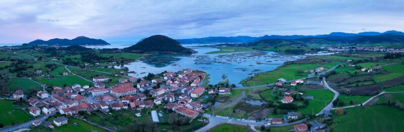
In the northern part of Spain lies Cantabria, a region known for its stunning landscapes and rich cultural heritage. Despite its small size - covering just over 5,300 square kilometers and home to about 588,000 residents - Cantabria is making significant developments using geospatial data on land administration.
The Foundation: Spanish national programs
Unlike the United States' unified 3D Elevation Program (3DEP), Europe lacks a centralized approach to lidar coverage, with mapping responsibilities delegated to individual member states. This has led to a fragmented landscape, where lidar implementation ranges from nationwide initiatives to local efforts. In Spain, the National Plan for Aerial Orthophotography (PNOA) and its sub-program, PNOA Lidar, provide a cohesive framework.
Launched in 2004 by Spain's National Geographic Institute (IGN) and autonomous communities, PNOA produces digital aerial orthophotographs of the entire Spanish territory, updated every three years with a resolution of at least 25 cm. In 2009, PNOA Lidar incorporated airborne laser scanning, also conducted by aircraft, generating digital elevation models with up to 0.5-meter resolution.
Cantabria has actively leveraged PNOA, co-financing aerial surveys and enhancing capabilities by conducting supplementary flights between the program’s triennial updates. This ensures continuous access to high-quality, up-to-date geospatial data, enabling improved data resolution and quality for regional applications.
From Lidar to Digital Twin
As geospatial technologies continue to evolve, high-resolution data capture has become the cornerstone of advanced spatial analysis. In Cantabria, this technological frontier is being pushed by a sophisticated approach to aerial imaging and data processing.
"Our computer vision techniques demand unprecedented precision," explains Gabriel J. Ortiz Rico, Head of the Cartography and Geographic Information Systems Service, Government of Cantabria. "And today, meticulously planned crewed airborne missions offer a wide range of advantages."
The region has partnered with AVT Airborne Sensing, a member of the European Association of Aerial Surveying Industries (EAASI), to capture the data. Selected through a public bidding process, as mandated for public sector projects, AVT initially planned to use a Cessna aircraft to cover the region over three to four days. However, due to persistent adverse weather conditions in Cantabria, a more agile solution was required.
AVT opted for a Beech B200 Super King Air, a faster aircraft equipped with a Vexcel Ultracam Eagle camera, capable of covering the entire region in just 1.5 days over approximately 15 hours of flight time. This strategic decision proved crucial as it significantly reduced the impact of weather constraints and allowed for efficient data acquisition within the limited timeframe. The aircraft's high sustained speed of over 250 knots contributed to this efficiency, enabling the completion of the mission with a longitudinal coverage of 80 percent and a transversal coverage of 60 percent in urban areas and 30-35 percent in rural areas, achieving a ground sample distance (GSD) of 18 cm.
The project presented significant challenges, particularly due to the adverse weather conditions and tight deadlines. To overcome these hurdles, AVT leveraged its state-of-the-art computing system in Greven, which enabled the rapid processing of the captured data into high-quality true-orthophotos and digital surface models (DSM) using dense image matching techniques. The successful execution of this project was facilitated by the strong collaboration between AVT and the Cantabrian government
Cantabria is now integrating True Ortho imagery into its workflow during designated flight years. This technology corrects surface distortions caused by terrain and building topography, offering a more accurate spatial representation of both urban and natural environments.
The resulting Digital Twin project, covering 533,000 hectares, represents one of the most extensive digital mapping initiatives globally. Utilizing 48 billion points collected through collaborative lidar flights with IGN, the project showcases the power of sophisticated data integration.
Esri's cutting-edge algorithms played a fundamental role in this transformation. By applying complex mathematical models, these algorithms converted raw point cloud data into solid, highly detailed 3D representations. The process captured over 600,000 buildings with remarkable fidelity, preserving intricate architectural details like irregular domes and complex chimneys.
The digital twin transcends traditional mapping, enabling comprehensive vegetation cover analysis, generating high-resolution land use maps, and providing sophisticated input for territorial functioning models. Researchers can now explore ecological connectivity and natural conservation with unprecedented spatial granularity.
The next step on the roadmap involves adding oblique imagery, which offers angled views that capture additional details not visible in nadir images.
AI-Driven Vegetation and Land Cover Mapping
Another interesting project showcases how artificial intelligence can be applied to existing datasets, such as aerial photography.
Cantabria has also developed an innovative AI-driven approach to map invasive species, specifically targeting Pampa grass (Cortaderia selloana). Using deep learning techniques from aerial photography captured in 2020, the government can now automatically detect and track the plant's spread across the region.
By training neural network algorithms on specific territorial samples, researchers created models that can recognize this invasive species across different landscapes.
The AI mapping provides high-resolution, reliable representations of the species' distribution. Once trained, the models can quickly analyze recent aerial images, enabling rapid monitoring of the plant's expansion and potential eradication zones.
This approach allows precise targeting of areas with high environmental value, transforming how invasive species are tracked and managed. The project serves as an early warning system, demonstrating Cantabria's technological innovation in environmental conservation.
Historical Change Detection
The detection of historical changes in the landscape is another pioneering project. The agency analyzed changes in the territory between 1957 and 2023, with transitions created by an AI agent.
This historical perspective is invaluable for understanding long-term environmental trends and planning future developments. For example, the agency has documented the expansion of natural forests in Cantabria since 1957, providing insights into the region's ecological health.
Vehicle and Human Activity Analysis
The Cantabria Mapping Agency has also utilized deep learning to analyze human activities, such as vehicle movement and population density. By detecting and mapping vehicles in urban and rural areas, the agency can identify patterns of land use and address issues like unregulated parking, a particular problem during the summer months when the Cantabria coast becomes a popular tourist destination. Additionally, they have developed methods for counting people on beaches, which proved useful during the COVID-19 pandemic to monitor social distancing and manage public spaces effectively. Photogrammetry flights made these analyses possible, which provided the high-resolution data needed for accurate assessments.
Challenges and Future Directions
Despite technological achievements, Cantabria's Mapping Agency faces significant challenges, particularly in securing technological environments for public administration. For Cantabria's Mapping Agency, this means implementing robust security measures while maintaining the agency's technological innovation and data accessibility. The challenge is balancing technological advancement with stringent security requirements typical in public administration environments.
Spain emerges as a global geospatial leader, backed by robust national programs like PNOA, a strong private sector, and skilled academic research. Cantabria exemplifies this national strength, transforming technological constraints into opportunities for groundbreaking spatial intelligence.
The agency's innovations - from precise digital twins to AI-powered ecological monitoring - represent more than technological achievements. They demonstrate how advanced geospatial technologies can fundamentally reshape our understanding of territorial landscapes, environmental management, and regional development.
By converting massive datasets into actionable insights, Cantabria is not just mapping a region - it's creating a new paradigm for intelligent, data-driven governance that could serve as a model for regions worldwide.