You can’t go anywhere near a conversation even remotely related to business or industry of any kind without artificial intelligence coming up in some form. Of course, in mainstream conversation this generally refers to generative AI, with products like ChatGPT and DALL-E, among others, dominating the discourse. While there is still some reasonable skepticism around the ultimate utility of these tools, they are no doubt technologically impressive and, if correctly harnessed, could change the way work is done.
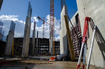
They are also, however, not even close to the only forms of AI that are flourishing in this current boom around artificial intelligence and machine learning. In fact, one could argue – and I would argue – that it’s not even the most valuable kind of AI. In the geospatial industry, AI has long been a part of the workflow as it’s a perfect fit for the space. Geospatial workflows include massive amounts of data, and having humans parse through all of it can both lead to errors and simply take massive amounts of time.
As such, the industry has been one of the biggest beneficiaries of the increased funding and attention being paid to AI in general, as their capabilities have grown in impressive ways over the last couple of years. Whether it be identifying anomalies or assets in satellite data or point clouds, having these automated processes saves times, and in some cases lives. Below, we’ll look back at six recent stories from Geo Week News that highlight the ways artificial intelligence and machine learning have been harnessed for asset identification and segmentation in geospatial work.
Powering disaster preparation with AI and geospatial data
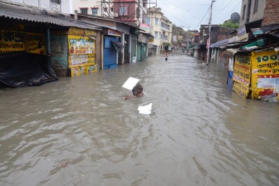
It wasn’t an exaggeration to say that, in some instances, utilizing AI in large-scale data can save lives. Today, natural disasters are becoming more common as an effect of climate change, but we also have better technology to both prepare for and react to these events. Satellite imagery is a huge part of that, with more frequent imaging coming in at higher resolutions than we’d ever previously seen. For this article, Geo Week News spoke with Gramener’s Sundeep Reddy Mallu about their AI model, Sunny Lives, which was created in partnership with SEEDS and Microsoft and identifies roof types on houses around the Indian coast to determine which areas may need the most assistance after a cyclone strikes.
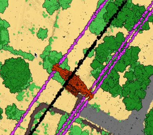
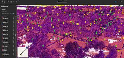
Leveraging AI for point cloud classification
Similarly to satellite imagery, point cloud data is extremely dense and can be difficult for humans to parse manually, making it an ideal field to be affected by this current AI boom. Slovenia-based company Flai is a prime example of how this is happening in the industry, with their algorithm around point cloud classification. This is generally an extremely tedious task that can be very time-consuming, but Flai and other companies have been quickly working to develop and iterate algorithms around more easily completing this work.
Will AI revolutionize the geospatial industry?
The answer to this question likely depends on your definition of the word “revolutionize,” but at the very least it’s safe to say that the industry is and will continue to be changed by artificial intelligence. This article offers insights from some of industry thought leaders and long-time practitioners around this data, with quotes from a longer report put together by Geo Week News in 2023. Find quotes from Nadine Alameh, Carlos Femmer, Florent Poux, and Asa Block about how AI will affect the industry, which have generally been spot on.
CARTO adds New Features to its Cloud Native Platform
Here, we have a more recent story about new features being added to CARTO’s Cloud Native Platform. The platform is used for decision making based upon climate datasets and satellite imagery, both of which are quite large and difficult to parse through, particularly for retail and telecom companies which may not specialize in working with this kind of data. This article highlights how the company is utilizing new AI-powered workflows for performing spatial analysis.
Mach9 wants to create maps 30 times faster than previous standards
Similar to Flai, highlighted above, Mach9 is a relatively new company that is using its knowledge of the industry and AI to help solve real problems experienced by professionals. The company’s founders met at Carnegie Mellon, one of the leading global institutions for robotics, and started out building mobile mapping hardware. As they moved along, however, they saw problems that needed solving on the software side and shifted. Now, founder Alexander Baikovitz says, they are looking to create “a new space of automated geospatial production.”
Esri Announces New Technology Updates at Developer Summit
Finally, we have an article from just this week about new capabilities within Esri’s ArcGIS platform. The article delves into a few updates that came from the company’s recent developer summit, and that includes new tools around “GeoAI.” Contributor Eric van Rees runs through some of these new updates in this article, including Esri making it easier for users to use Meta’s Segment Anything Model.