


The plenary session of this year’s Esri Developer Summit in Palm Springs, California featured multiple new technology announcements. Of special interest are a new application for creating data pipelines called ArcGIS Data Pipelines and new AI tools for spatial data workflows. A selection of the 2024 Esri Developer Summit plenary videos can be streamed here.
ArcGIS Data Pipelines
ArcGIS Data Pipelines is a new application available in ArcGIS Online for accessing, processing, and integrating data from a wide variety of sources. It offers an intuitive drag-and-drop interface where users can create reproducible data preparation workflows without writing any code. It was previewed during the DevSummit’s plenary session in Palm Springs, and will be available locally through ArcGIS Notebooks after the release of the ArcGIS API for Python version 2.3.0.
A data pipeline is a set of tools and processes used to automate the movement and transformation of data between a source system and a target repository. The tool documentation explains that ArcGIS Data Pipelines lets users connect to and read data from where it is stored, perform data preparation operations, and write the data out to a feature layer that is available in ArcGIS. The Data Pipelines interface enables users to construct, run, and reproduce data preparation workflows. Data pipelines can also be scheduled to run at regular intervals.
New GeoAI tools
Esri has been integrating AI tools into its ArcGIS platform. There are three different ways in which AI capabilities can be accessed: through the ArcGIS API for Python, through geoprocessing tools, and finally a set of pre-trained models. ArcGIS Online includes the Living Atlas of the World, a collection of maps, apps, and data layers. It also includes 70+ pre-trained AI models that users can download and use as input models for geoprocessing models for AI or to refine their datasets. The benefit of these pre-trained models is that they save the user a lot of time and effort to train data.
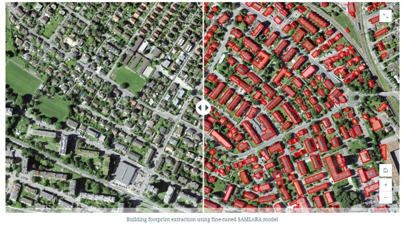
The most popular pre-trained model is Meta’s Segment Anything Model (SAM), which can be used for a variety of use cases as it allows segmenting any kind of object in any imagery. The popularity of this pre-trained model lies in its broad applicability, but often requires additional tools, which is why Esri announced two ways to extend the existing SAM during the Developer Summit. The first option is to use the Text SAM deep learning package, that enables object segmentation from imagery through text prompts. This video explains how to use the model. Second, the SAMLoRA model significantly speeds up data training using the LoRA data training technique.
Another recent AI integration into Esri’s ArcGIS platform was demoed earlier this year at the Federal GIS Conference. This video shows how ArcGIS and generative AI assistants were combined to provide citizens with location-based information after asking questions about their living environment.


