

Geodetics, Inc. is a navigation technology company, established in 1999 and based in San Diego, California. Its team of visionary scientists and engineers are esteemed experts in the fields of geodesy, navigation and multi-sensor (GNSS/IMU) integration.
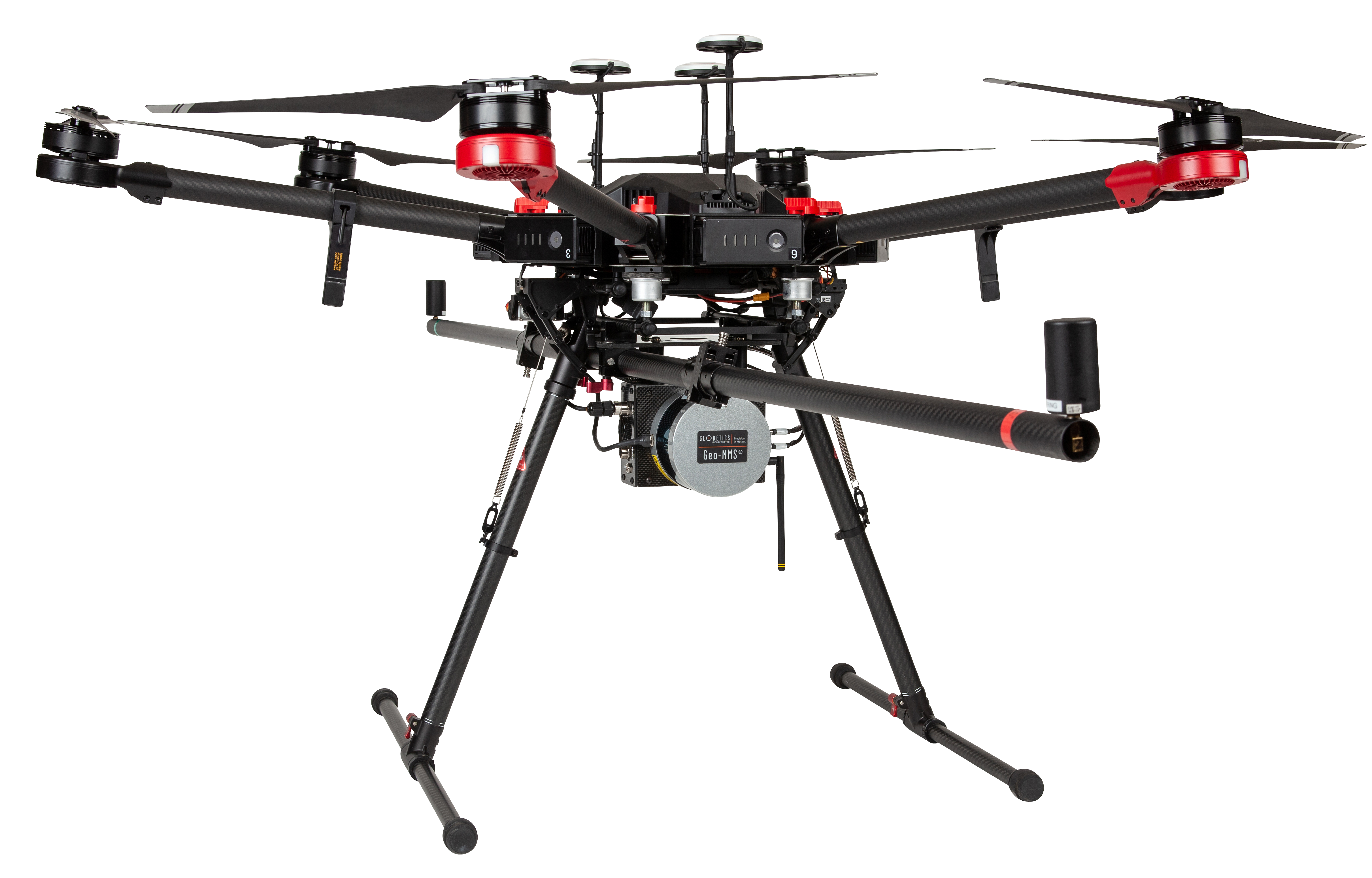
The Geo-MMS (Mobile Mapping System) product suite offered by Geodetics includes LiDAR-based mapping systems, Camera-based systems, LiDAR/Camera (Point&Pixel™) systems, and turnkey UAV systems for tactical (up to 75m), mid-range (up to 200m) and long-range (up to 700 m) mapping flights. Geodetics works collaboratively with Camera and LiDAR technology developers including Sony (RGB, Multi-Spectral, Hyper-Spectral), FLIR (IR, ladybug), Velodyne, Quanergy and Optech to provide its customers an array of options to pick and choose the sensor and system best suited for their application and budget. The Geo-MMS suite has a rich customer base and Geodetics customizes its systems to cater to application dependent objectives, terrain types and other parameters.
UAV applications are boundless, from BIM and surveying to oil and gas, environmental, infrastructure, forestry and archaeological applications. In addition to UAV applications, Geodetics provides mapping solutions and mounting platforms for ground vehicles, as well as support for autonomous driving projects through the real-time multi-sensor fusion of GPS/IMU/Camera/LiDAR sensors. Ground-vehicle applications include road and bridge inspection and overhead powerline mapping.
Photogrammetry systems can be effortlessly integrated into the UAV LiDAR system or used independently. The integration of the two produces stunning colorized point clouds, with options for RGB, multi-spectral or hyper-spectral data, and additional options in the near future including methane detection. For Geo-Photomap and Point&Pixel systems, the user can switch the camera from horizontal (nadir) to vertical (useful for building and tower inspections) in seconds. Use of standard photogrammetry grade cameras as well as 360° spherical vision systems such as the FLIR Ladybug5+ camera allow for seamless cross-use between UAV and ground-vehicle platforms.
With an experienced team of navigational scientists and engineers, Geodetics fully develops the MMS line of products internally. As a U.S. Department of Defense supplier, Geodetics leverages the power accumulated through years of research and development in Position, Navigation and Timing (PNT) to provide unparalleled precision and accuracy with the GNSS/IMU solutions in the developed products. Geodetics uses multi-sensor fusion as the keystone of its solutions. The company benefits from its experience in both defense and commercial demands, leading to innovations in technologies which can be used in both.
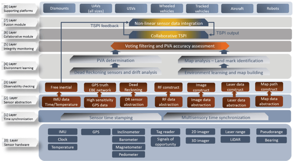
This schema illustrates the company’s multilayered approach and helps explain how it can apply its expertise, starting from GNSS/IMU roots, to a broad range of applications.
All system technology is designed and built from the ground up, in-house at the company’s base in San Diego, California. With the expertise available on-hand, the team expands the initial GPS/IMU algorithms and science into fully developed turnkey systems. The Geo-MMS Navigator system contains the GNSS receivers, MEMS IMU, radio and various subsystems, including an extended Kalman filter software to integrate the sensor data in real-time and record them for post-processing. The navigator supports several different GPS receivers and different IMU grades as well as support for auxiliary aiding sensors.
DJI Matrice 600 Pro, easy assembly and flight, powered by battery with a total payload weight of ~ 2.7 kg (6 lbs.).
Customers can rest assured that their LiDAR navigation solution is unmatched in both quality and reliability. The LiDAR/camera payload is rigidly attached to the mounting assembly, which in turn is rigidly attached to the calibrated rails on the drone or vehicle. Hence, the payload can be changed but, owing to the rigid connectivity, the calibration remains fixed. The team of scientists actively publish in areas on the bleeding edge of navigation science, particularly in geodesy and GNSS/IMU integration. The team energetically communicate their work and research through peer-reviewed publications in journals such as Journal of Applied Geodesy as well as through vehicles such as LiDAR Magazine, presenting new research at technical meetings (e.g. Institute of Navigation) and through the blog section of the Geodetics website.
The UAV mobile mapping market has increased substantially in the last decade or so, as UAV prices continue to drop, and their use becomes more widespread and diversified. The integration of a GPS/IMU module is required for accurate time-tagging, geo-tagging and direct-georeferencing of both LiDAR and camera sensor data for UAVs. Many vendors in the UAV mobile mapping sector rely on third party navigation technologies to perform the necessary mathematical operations required for accurate UAV navigation. This can act as a limitation on the vendors product capabilities, as the companies act as system integrators, not system developers. These systems may fill the required needs of customers.
However, issues arise when these vendors lack the in-house expertise to respond to technical issues in a timely manner. Instead, they must liaise with their third-party technology developer to address technical issues which arise with their customers. Because of this delayed two-step process, Geodetics stands out from the crowd. By being the sole developer and manufacturer of all direct georeferencing equipment and software, Geodetics fills this niche in UAV mobile mapping market. If an issue or question arises concerning system performance, who better to ask than the people who developed it?
Successful product branding and marketing work perceives such vendors to being on par with the technology developers. However, they are fundamentally limited by the performance capabilities provided by the third-party product. As the technology and software developer, Geodetics is well placed to be flexible in approaches to system modifications and providing enhanced capabilities to existing systems. This flexibility affords the company adaptability, and the ability to innovate. With Geodetics, the company’s expertise is embodied not just in the finished product, but with the array of accompanying data visualization and processing software and quick turnaround customer support/troubleshooting for resolving technical issues.
Continued research and development and spirited company expansion within the sector will broaden existing horizons and open further doors for future growth. As emerging technologies and companies expand the horizons of commercial applications with LiDAR and camera sensors. Geodetics anticipates a bright and prosperous future in the Point&Pixel mapping sector. Aided by its continued development of technologies for its Defense customers and contracts, the commercial LiDAR mapping capabilities of the MMS suite of products will only improve from its already well-established position in the market.
This content was sponsored by Geodedics, Inc. For more information, please visit their website.


