

The value of geospatial information for decision-making and understanding our world can’t be overstated. Geospatial data allows us to see the unseen patterns governing our built and natural world, and the insights gained from this data can be life-altering. As artificial intelligence continues to reshape many industries, it has also taken hold in the geospatial world. The emergence of “GeoAI”, defined as the fusion of geospatial data, sensing technologies, and AI-driven insights, is a critical shift and will likely redefine how organizations capture and interpret geospatial information.
Geo Week News connected with Dr. Aaron Morris, Innovation Principal at Woolpert, to explore how GeoAI is transforming traditional workflows, where the technology stands today, and what’s on the horizon. With more than 25 years of experience spanning AI, robotics, and digital twins, Dr. Morris holds a Ph.D. in Robotics from Carnegie Mellon University and has founded multiple startups focused on AI-powered infrastructure and autonomous systems.
Can you start by defining GeoAI, and why it has become such a pivotal area of innovation for organizations like Woolpert?
GeoAI is fundamentally the application of AI technologies to understanding geospatial data. The inclusion of the “Geo” is crucial, as it classifies this field as a unique problem set and opportunity for the geospatial industry. I personally view GeoAI as the combination of sensing, AI, and GIS data. While AI is broad and covers many areas, including large language models, the sensor element and the massive scale of geospatial data make GeoAI unique.
For Woolpert, and honestly, for anyone in the geospatial world, GeoAI is pivotal because it is a disruptor. Historically, geospatial data has been challenging to manage due to its scale—dealing with small, critical details about the world on a massive level. For example, running a process on city data might result in 100,000 visible assets, which would take an enormous amount of time to analyze manually. GeoAI will be a game-changer, allowing us to understand the world in ways we never have before.
What factors make the current moment unique for applying AI to geospatial data?
This acceleration is enabled by several key technological advancements. First and foremost is the maturity of cloud infrastructure. We now have the ability to quickly spin up instances that already include machine learning platforms like TensorFlow, which was not as easily doable even a few years ago. When I started my career, you had to build these tools yourself.
We are also seeing the maturity of tools for human labeling, which remains a significant component of AI development. This includes the development of labeling industries and platforms like reCAPTCHA working behind the scenes.
The combination of these frameworks and the general excitement around AI is fueling this movement. People who were historically skeptical or delayed adoption are now engaging. The shift in the industry’s reaction to AI in just the last year and a half has been fascinating.
Can you provide examples of specific use cases where Woolpert is leveraging GeoAI?
GeoAI is being used across a wide variety of applications. While many people initially imagine finding objects, such as identifying building footprints from satellite or orthoimagery, the reality is much broader. We are heavily involved in identification and segmentation—drawing lines and labeling specific features in images.
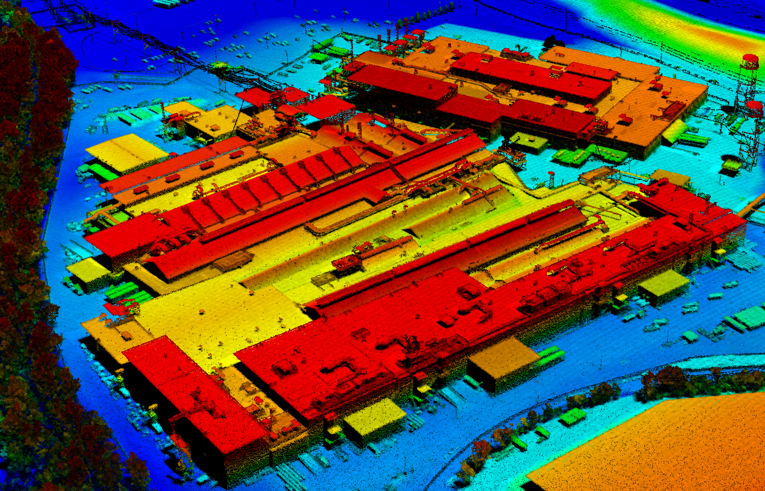
One of the very first applications our team tackled at Woolpert was data cleaning. When a point cloud comes in, it includes sensor noise, environmental noise, and random points that must be filtered out. While traditional, human-made filters exist, GeoAI helps identify complex patterns, such as classifying ground points when a stockpile of material is present; whereas historically a human had to determine if it was a pile or a hill. We are encoding and streamlining that human expertise.
Beyond typical classification (building footprints, land use, etc.), we are increasingly focused on change detection. The world is vast, and tracking small-scale changes over time is difficult. GeoAI systems allow us to track and understand how the world is changing in ways previously unseen. This includes applications like landslide detection and subsidence. Marrying this with weather data could identify instances where a landslide might occur near critical infrastructure like roads or pipelines.
Interestingly, applying AI also forces better data organization and management. To effectively train an AI system, data must be well-organized on servers with proper naming conventions, accurate security permissions, and a consistent file structure.
What are some of the biggest challenges remaining in turning geospatial data into actionable information?
This challenge highlights why GeoAI is unique compared to AI as a broad category, and it comes down to sensing. Unlike large language models that mine digital human content (the written word) for patterns, geospatial data relies on sensor data, which are interpretations of the world through lidar, cameras, and electrical optic devices. This requires its own level of interpretation.
The challenges stem from three main areas:
- Sensor noise and error: Every sensor produces some level of noise and comes with an associated error bar for accuracy.
- The capture process: How the sensor is mounted (on a vehicle, handheld, etc.) and how it traverses its environment introduces noise and uncertainty.
This is the classic “garbage in, garbage out” problem. A major current challenge is getting AI to understand where issues exist, such as identifying noisy data. We still encounter a variety of edge cases and scenarios for which models haven’t been trained to adapt.
A second significant challenge is the ability to label. To train a model, you need “priors”, which is information from experts who can confirm, for example, “yes, this is a stop sign”. Without this expert validation, AI doesn’t know what to do with the data. This training process is rate-limited by the number of experts available to conduct these assessments. This has led to discussions, potentially emerging in the next year, about how to acquire training data, including the use of synthetic training data.
Can you share a success story illustrating how GeoAI has improved outcomes?
We have been heavily applying this work to our internal workflows and have seen multiple benefits.
The first benefit is often the main motivation behind investment in GeoAI, but is often the most misunderstood. We often want to believe that AI will produce results faster than its human counterparts, but speed alone is not enough since rapid results without reliability do not instill trust. Instead, we see success with GeoAI to empower our GEOINT analysts to tackle more complex challenges in AI-amplified workflows. For example, when an action is needed, such as an edit to a point cloud, the system identifies the issue and prepares an edit to suggest automatically, much like spellcheck. This approach has yielded significant quality improvements, resulting in fewer issues found in QAQC.
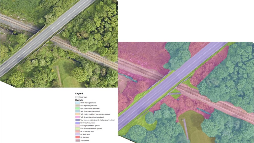
We have also seen AI model performance boost the fidelity of inference in information extraction work. For example, in a recent project, we were tasked to classify different land types (e.g., forests, grasslands, developed land, etc.) adjacent to a transportation corridor. The corridor was tens of miles in length, but we only used a small portion of that data for training. Training involved drawing boundaries around each land type and then applying the appropriate land type, which you can imagine was a laborious task for our subject matter expert. Those labels were understandably coarse, often being “boxy” polygons that “mostly” captured the land type. Imagine our surprise that once trained, the AI drew meticulous boundaries around each and every bush, rock, sidewalk, and ditch to accurately trace the land-type groups. Not only were we surprised, but our clients were blown away as well
At Geo Week, you’re running a workshop on “unpacking” GeoAI. What do you hope that attendees will take away from the workshop?
If there’s one key takeaway that I want attendees to gain, it is the language and understanding necessary to have informed conversations with vendors providing AI platforms and solutions. We are currently saturated with AI solutions, and there is a risk of vendors overpromising and underdelivering, which spoils the technology for everyone.
Attendees need to understand what is real versus what is not and distinguish between near-term and far-term capabilities. It is critical to grasp the fundamentals: For instance, how you treat imagery is different from how you treat lidar, as they have different computational representations and therefore different compute costs. Understanding feasibility helps manage expectations so that when people engage with these technologies, they do so successfully.
How do you see the relationship between human expertise and AI evolving in this environment?
I like to frame the current relationship between humans and GeoAI as one of “the Great Encoding”. Experts have spent years interpreting geospatial data, creating digital products like digital Surface models (DSMs). These experts are now creating the labels needed to train the AI systems.
This phase of labeling and training will continue for some time. Eventually, the transition will shift from humans creating labels to humans validating AI output. AI will provide the first pass or first check, which humans will then review and validate.
Following this validation phase, as confidence grows and multiple models offer similar hypotheses (allowing for cross-validation), AI’s output will become more trusted. We might reach a point where it is hard for people to compete with the accuracy of the systems.
For example, I recall one of my first mobile mapping projects involving a bridge clearance reporting project for Caltrans where the system calculated measurements that initially contradicted records on file. However, after checking, the crew found that the lidar was correct (e.g., finding trees growing underneath the structure that were not anticipated). By the end of the project, they trusted the machine over their database. This suggests a natural evolution where, though people are currently everything to the success of GeoAI, the machine will eventually lead.
Beyond traditional digital twin applications, what other domains or industries stand to benefit from GeoAI in the future?
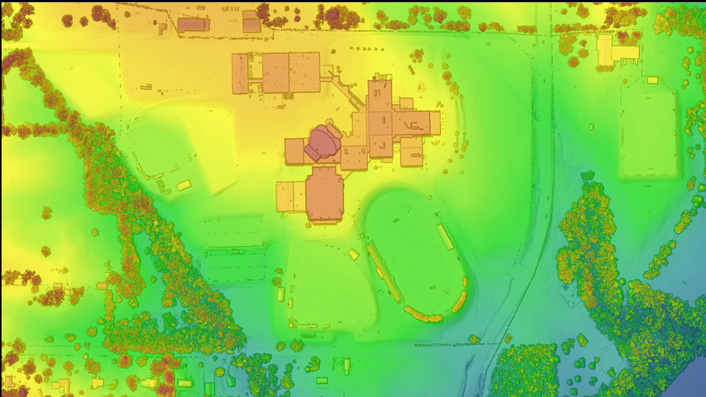
While predictive capability is challenging, there are many opportunities. We are moving toward creating a true digital twin of our infrastructure at massive scales. Historically, digital twins focused on man-made objects like engines (drawing from NASA/space roots), but the current focus includes natural artifacts that we are trying to model as the data comes in.
Any sector in the utility space stands to benefit, including power, oil, and gas, by understanding the location of assets. It is surprising how much infrastructure exists in the world—like a new pole, railroad crossing, or barrier—that hasn’t been officially recorded.
The digital twin element is critical not just for creation but for maintenance. Historically, once a massive effort was spent on scanning, capturing, and digitizing the environment to create a baseline GIS model, the world quickly changed, making the data outdated. Re-scanning the entire environment every time is not feasible. GeoAI comes into its own here because it both speeds up the initial creation of the twin and helps focus where change has occurred. This allows organizations to target detailed analysis and secondary modeling only on those small areas that have changed.
How do you envision GeoAI transforming Woolpert’s services and the broader geospatial industry in the next couple of years?
For Woolpert, I believe GeoAI will be heavily woven into the fabric of everything we do. There will likely be no data collection that is not validated or cleaned through some kind of AI process. Furthermore, data products – whether land use or other derivations – will have an ever-increasing chance of being created through an AI process. This is because AI will increase the quality of the product and improve how we price and deliver it.
From an industry standpoint, there will not be an organization or agency that isn’t impacted. For example, highway safety and the integrity of America’s transportation system can and will be improved by applying GeoAI at a programmatic level at the USDOT. As the United States moves toward a future shaped by autonomous mobility and smart infrastructure, two foundational advancements are urgently needed: standardized high-definition (HD) maps for self-driving vehicles and Internet of Things (IoT) standards for real-time monitoring of bridges, roads, and rail systems. These initiatives will dramatically improve public safety, infrastructure resilience, predictive maintenance, and transportation efficiency, creating a more secure and vibrant economy when applied to all city, state, and federal infrastructures. My guess is that such matters will become important policy considerations that will manifest in the upcoming decennial Surface Transportation Bill, which is due to be considered in 2026.
What is the single most important thing you want the geospatial community to understand about GeoAI?
The biggest thing is the potential for accessibility to a broader audience. Geospatial data is immensely valuable, but traditionally, accessing and utilizing it required a high level of expertise, extensive training, college degrees, and specialized skill sets.
AI has the capability to make geospatial information much more accessible. The benefit to the industry is immense: it opens up opportunities for new applications and businesses to be created on top of this data that were previously inaccessible to a broader audience. This enablement allows people to be creative in ways they haven’t been able to before, which I believe will be the biggest benefit of GeoAI.


