

Contributed by The JP Global Digital Team
If we look back, AEC and EPC companies have spent decades using blueprints and other 2D plans for most of their work, like assembly/disassembly of equipment and facility expansions for example. In the case of equipment disassembly, a common problem was having outdated plans, which are not reliable documents or references for when planning and estimating this kind of project. Many companies would choose to survey the field before starting each project, however these activities take up a lot of time and resources, and are prone to human error, which in turn can generate more delays and budget issues given the inaccuracy of the data gathered.
In comparison to other techniques, we can see a growth in the adoption of lidar and point cloud technology in the industry, with the latter specifically having a very positive impact on AEC companies that conduct equipment disassembly projects. Using software that unlocks the potential of this type of data, engineers can virtually emulate the physical conditions of the environment where the equipment is located which gives them valuable insight on how to conduct said project.
As you may know, space is used to the maximum in complex plants and facilities; equipment is installed in close proximity to each other, leaving only the needed space between them. Once a piece of equipment has reached the end of its life cycle it must be removed from the area and replaced with a new one. To achieve this, it is commonly necessary to affect the other elements present in the area, for example cutting adjacent pipes, removing walls, disconnecting wiring, etc.
This is exactly where the challenge for engineers arises; they must analyze the situation and come up with the optimal extraction route - the route that has the least impact on the plant’s operation and that generates the lowest possible cost and risk. Additionally, these projects need a lot of collaboration between several departments; you’ll probably find a mechanical engineer working with an instrumentation technician while communicating with the HSE personnel. Everyone needs to have the same information.
This is where JP Interactive Viewer (JPIV) comes in - a web-based solution for 3D data visualization, management, and sharing. It is designed to solve these types of problems and empower every kind of user, regardless of technical knowledge or available hardware.
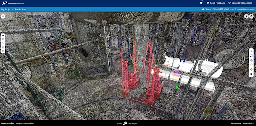
Using JPIV, engineers can simulate the equipment extraction by overlaying the point cloud and the 3D model; this way they can understand the possible problem areas where the equipment may collide with other elements and plan accordingly. At the same time, the HSE personnel can analyze the areas that pose the greatest risk for the project and place annotations on the point cloud for the reference of the rest of the team. JPIV also solves the collaboration challenges by centralizing everything in a highly accessible platform that lets users share information with just a link.
This type of centralized collaboration is the future of AEC and EPC projects. Point clouds, BIM models, and all the other information needed to complete a project, are brought together in one place.
If you're ready to learn more about how JPIV can help you transform the way you manage your Point Cloud-enabled projects and collaborate with your team and clients, contact JP Global Digital and book a demo!


