
For decades, businesses, government agencies, military personnel, and everyday citizens all around the world have relied on GPS technology for navigation. These satellite-based positioning systems have proved to be a low-cost, easy to use, and safe option for everything from helping ships stay on course to enabling motorists to get to their destinations to guiding aircraft to their landing spots.
Although there are many advantages of GPS, there are also significant drawbacks, particularly around GPS interference. Increasingly, GPS denial, jamming, and spoofing are disrupting commercial and military aviation and maritime operations. GPS interference poses significant threats to transportation safety, national security, and operational continuity in business and government activities.
Fortunately, many experts and researchers are working on new approaches to navigation. For example, SandboxAQ is developing solutions based on magnetic navigation or “MagNav.” Described by Sandbox AQ as an “Alt-PNT solution that operates independently of satellites,” MagNav draws inspiration “from migratory species that navigate using Earth’s magnetic field.” According to SandboxAQ, “modern systems now use quantum sensors and AI to detect subtle, location-specific variations in the planet’s crustal magnetic signature—effectively turning geology into a global reference layer for positioning and navigation.”
To learn more about MagNav, Geo Week News recently spoke with Luca Ferrara, Sandbox AQ’s GM of Navigation, and
How big of a problem is GPS denial, jamming, and spoofing?
Ferrara: Instances of GNSS denial, jamming and spoofing continue to increase globally. For example, from August 2021 – June 2024, IATA.org recorded over 580,000 instances of GNSS interference from 18.4 million flights analyzed. Last year, a GPS Spoofing Workgroup report showed incidents grew from ~300 in January 2024 to ~1,500 through August 2024, with 41,000 incidents between July 15 – August 15 alone. In highly contested areas such as the Baltic, Black, Mediterranean and South China Seas, for example, GNSS interference impacts the effectiveness of military operations over land, sea, and air, jeopardizing the lives of millions of warfighters and civilians, and billions of dollars in equipment and infrastructure.
What are the impacts of GPS interference on commercial operations?
Ferrara: Beyond the military, GNSS interference significantly impacts commercial airline flights and impedes maritime operations. It also impacts the effectiveness of emergency response teams and other commercial apps such as food deliveries. The loss of such systems would impact power grids, financial transactions, and cellular networks, with estimated losses totaling more than $1 billion USD per day.
What is magnetic navigation and how can it address the problems caused by spoofing, jamming, and denial?
Ferrara: Magnetic Anomaly Navigation, or MagNav, leverages advanced sensors, AI, signals from Earth’s crustal magnetic field, and known magnetic anomaly maps for navigation. Every square meter on Earth has a distinct magnetic signature—like a geological fingerprint—which MagNav systems can capture and interpret, using advanced AI to remove external interference and calculate an object’s position with incredible accuracy. They can operate any time of day, in any weather, over any terrain—even under water—and are not susceptible to external jamming, spoofing, or denial. They also do not emit any detectable signals that could be used for tracking purposes.
How can MagNav improve navigation?
Ferrara: From a navigation standpoint, MagNav represents a crucial step forward in future-proofing civilian and military navigation systems against emerging threats, ensuring operational continuity and safety for crews, passengers and equipment. Systems like SandboxAQ’s AQNav provide a robust, resilient GPS alternative that complements existing navigation systems (e.g., inertial, celestial, visual, etc.) without satellites, although it has demonstrated its ability to act as a primary navigation source and meets aviation industry standards for required navigation performance (RNP).
What do geospatial professionals need to know about MagNav?
Angappan: MagNav is fundamentally integrated with and will greatly enhance geospatial characterization. The solution employs sensitive sensors and state-of-the-art AI to capture the full natural magnetic field spectrum (including core, crustal, and external fields) and precisely extract a clean crustal anomaly field. This provides a robust, non-GNSS dependent Alternate PNT source, guaranteeing navigational accuracy and data integrity for all geospatial missions in environments where satellite signals are unavailable or intentionally denied. Critically, every navigation flight is simultaneously a mission that characterizes the planet’s complex magnetic signals with unprecedented precision.
How can geospatial professionals benefit from MagNav technology?
Angappan: MagNav’s dual functionality means that every flight, while securing precise navigation, continuously observes and improves the quality of the underlying magnetic geospatial data. The system automatically identifies key areas requiring magnetic map refinement, enabling continuously improved data capture that scales magnetic characterization efforts. This rich data collection enables advanced applications, such as monitoring changes in the magnetic signature over time to create a high-resolution geospatial change detection layer. This layer proactively identifies and monitors changes in subsurface materials, infrastructure integrity, and geological activity (like fault movement), significantly improving the spatial accuracy and confidence of crustal field models for various applications.
Furthermore, the capability to measure and accurately model the time-varying external magnetic fields (the space weather and induced component) provides a critical, dynamic geospatial intelligence service. This feature generates continuously updated, spatially aware models of geomagnetic activity. These models are essential for predicting and mitigating the risks of geomagnetically induced currents on vulnerable, spatially extensive infrastructure, such as power grids and railways. By providing this dynamic, high-fidelity data, the MagNav solution delivers unique and essential intelligence that secures mission operations and critical national assets.
I understand that SandboxAQ conducted tests to determine the effectiveness of MagNav. Can you discuss the results?
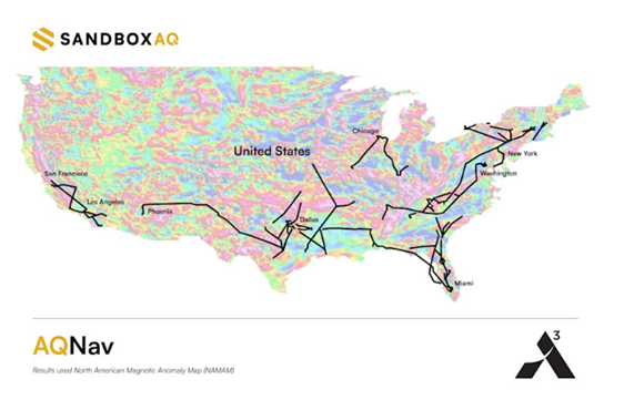
Ferrara: SandboxAQ has been testing and refining AQNav since 2022, and completed its first flight-tests with the U.S. Air Force (USAF) in May 2023. Since then, we have continued conducting flight tests with the USAF, aircraft manufacturers like Airbus and Boeing, and other partners. In July 2024, AQNav demonstrated its ability to act as a primary source for real-time navigation during USAF flight tests. A year later, we announced the results of the largest, most comprehensive MagNav test conducted to date – a five-month, nationwide initiative with Acubed, the Silicon Valley innovation center of Airbus.
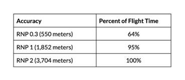
The goal was to determine whether AQNav’s navigational accuracy could meet the aviation industry’s Required Navigation Performance (RNP) for deployment on military, commercial and civilian aircraft. After more than 150 flight-hours and 44,000km flown between 200 airports, data showed that AQNav achieved RNP2 (i.e., navigational accuracy within 2 nautical miles; which is required for en route travel between airports) 100% of total flight time, and RNP1 (i.e., accuracy to within 1 nautical mile; required for airport landings) 95% of total flight time. It also achieved RNP0.3 – accuracy to within 550 meters – an unprecedented 64% of flight time, and achieved its best-observed accuracy of less than 74 meters with the assumption of using inertial systems common to today’s aircraft. A figure which could improve as these systems also improve. By consistently maintaining accuracy across an uncontrolled, unfiltered national testbed, SandboxAQ demonstrated the viability and true operational robustness of AQNav in real-world scenarios.