
By Christine Byrne
At Accurate Surveying & Mapping, a Boise, Idaho-based geospatial firm led by Nathan J. Dang, PLS, much of the work focuses on delivering high-quality data for restoration, land development, and historical preservation projects. In preservation workflows in particular, the challenge is often balancing survey-grade precision with non-invasive data collection to avoid disturbing fragile, century-old structures.
Increasingly, digital twin methodologies are being used to bridge the gap between historical significance and modern engineering requirements. These projects demand accurate boundary data and detailed structural insight, while also requiring workflows that minimize physical impact.
One example is a project at Soldier Townsite in Camas County, Idaho, a semi-occupied ghost town where the focus was Goff’s Hall, an opera house built around 1907. The client’s objective was to understand boundary lines in relation to the structure to guide future restoration and development.
Traditional survey methods alone would have been slower and would not have provided the level of detail required for precise restoration planning. Aerial photogrammetry could deliver site-wide context, but not the fine-grained vertical and structural detail needed to fully assess the building. At the same time, any solution had to avoid physical interaction with the structure itself.
To address these constraints, the team evolved its workflow into a hybrid capture approach, combining aerial and terrestrial data collection.
Aerial data was captured using a DJI Mavic 3 Enterprise, producing high-resolution photogrammetry of the entire townsite. This provided a survey-grade base map of terrain, building footprints, and vegetation, establishing the broader spatial context.
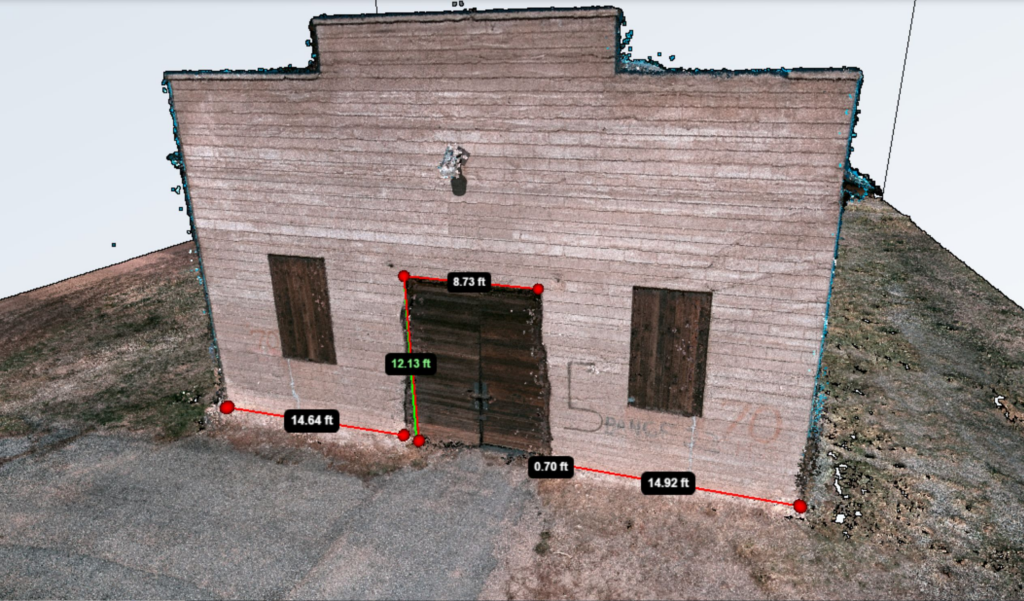
To capture the level of detail required for restoration planning, ground-based imaging was introduced using Looq AI’s qCam, a handheld reality capture device for collecting high-resolution, survey-grade 3D imagery. By walking the perimeter of Goff’s Hall, the surveyor collected sub-centimeter, photorealistic 3D data of the brickwork, wooden doors, and foundation. This terrestrial capture complemented the aerial dataset by resolving details that would otherwise be missed.
Alignment and control were supported by a Javad LS System GPS. During the project, a federal government shutdown temporarily halted GPS coordinate conversion, and a separate server outage introduced additional complications. To maintain progress, the team relied on assumed coordinates, allowing both data collection and processing to continue without interruption.
Both datasets were processed within the Looq Platform, a software environment for aligning and generating structured 3D models from captured data, where aerial and terrestrial data were combined into a unified model. The result was a survey-grade digital twin of Goff’s Hall and its surrounding site.
The level of detail captured revealed structural conditions that had not been previously documented, including a deteriorating concrete foundation requiring repair. At the same time, the workflow proved efficient in the field, with data acquisition completed in two scans of approximately 15 minutes each and alignment requiring roughly 10 minutes per scan.
The resulting model provides a baseline for monitoring structural changes, erosion, and vegetation encroachment over time, while also enabling remote analysis and reducing the need for repeated site visits.
As Dang notes, “This project showcases how Looq AI bridges historical preservation and modern surveying practice—honoring the past while equipping restoration teams for the future.”
The project highlights a key limitation of relying on a single capture method. While aerial photogrammetry is effective for mapping and context, it does not consistently capture the level of detail required for structural evaluation. Ground-based imaging, while highly detailed, lacks broader spatial coverage. By combining the two, the workflow produces a more complete and actionable dataset.
Equally important was the ability to adapt in the field. The use of assumed coordinates during GNSS disruption ensured that the project remained on schedule without compromising the integrity of the dataset.
For projects requiring both spatial context and fine structural detail—particularly in historic preservation—hybrid capture provides a practical alternative to relying on aerial or terrestrial methods alone. As digital twin workflows continue to evolve, approaches that integrate multiple data sources are likely to play an increasingly important role in documenting and preserving historically significant sites.