


The surveying and mapping industry has been among the most emphatic and earliest adopters of UAV technology, if not the number one industry on that list. It bucks the stereotypes a little bit around older industries being averse to technology, but the fit has been made clear. Also made clear has been the importance of georeferencing the data collected by these drone surveys, ensuring the accuracy of collected data. In fairness, this was also a necessity for crewed airborne surveys, but it’s still an important factor for newer companies to keep in mind who may have UAV expertise but are still learning some of the dos and don’ts of surveying and mapping.
There are different ways for surveyors to georeference their data, with the methodologies varying in the accuracy they produce, the work it takes to properly set them up, and the time it takes to complete a project with those techniques. The truth is, a lot of these techniques can be labor-intensive, and often require a large amount of overlap in flight path, meaning it can take a relatively long time to complete the project. Direct georeferencing works to overcome some of those barriers created by older methods. One company specializing in this technology is Applanix, and Global Sales Manager Brad Schmidt took some time to speak with Geo Week News to talk about direct georeferencing, and what it can do for UAV surveying in particular.
What is Direct Georeferencing?
It makes sense to start right at the beginning, looking at what exactly direct georeferencing entails. Before we get there, though, it’s also important to note that it’s not really a new technology. This type of georeferencing has been used in crewed air surveys, but is a newer idea in the world of UAV surveys. Essentially, direct georeferencing, which Schmidt notes is an “evolution of technology,” takes the GNSS that is used, for example, in PPK surveying techniques, but also adds in an inertial system. By doing so, surveyors can receive the positioning information received from the GNSS while also adding in the orientation data which is gleaned by the inertial measurement unit (IMU), providing even better accuracy than the already good data coming from other systems.
Schmidt describes the evolution from aerial triangulation to PPK to this direct georeferencing technique. Applanix has worked to produce a number of solutions that are compatible with UAVs to put direct georeferencing, including their flagship board, the APX-15.
What does direct georeferencing add?
It’s great to understand what exactly direct georeferencing is and does, but it goes without saying that potential adopters of this methodology are going to want to know what exactly it adds to the surveying process that is not provided by other tools. As mentioned at the top, it’s fair to say surveyors are more willing to take a technological leap than some other older, established industries, but there still needs to be a clear return on investment down the road. Schmidt notes that there are two main advantages to direct georeferencing from which surveyors can benefit.
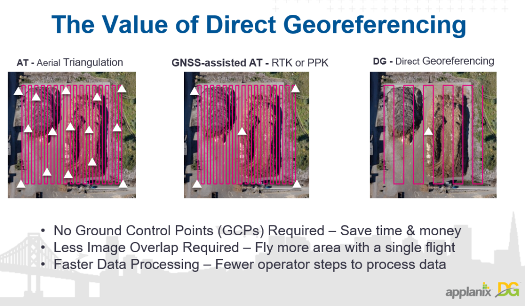
Number one is that “you don’t really need ground control points.” Accurate data an be collected with just a simple check point to validate the data. This leads to a couple of big value adds for surveyors. One is making for a safer work environment, as humans don’t have to go out and set up those ground control points, which can sometimes be in remote areas. That also opens up additional potential projects which can be completed with survey-grade accuracy, as some potential areas perhaps could not be captured with other georeferencing techniques if people couldn’t physically get out there to place the control points. And it also saves a significant amount of time on top of that.
The other way direct georeferencing saves time is that it requires less overlap in terms of the UAV flight lines. Typically, as Schmidt points out, surveyors fly with an 80 percent overlap to ensure they collect all of the data they need, which essentially means flights are lasting almost twice as long as they theoretically could without that overlap. While there’s still some overlap required with direct georeferencing, it’s significantly smaller, leading to longer flight times and/or shorter time commitments to complete a project.
What are the use cases?
Given the advantages of direct georeferencing discussed above, it’s clear there are plenty of project types which can benefit from this technology, but Schmidt also added a few specific examples which could particularly benefit from DG. One is the aftermath of a natural disaster like a landslide. In this scenario, it certainly would not be safe or feasible for ground control points to be placed within the affected area, but it can also be important to get data about the area to compare it before and after the incident. Given that direct georeferencing doesn’t require those ground control points, data can now be collected from that area using a UAV. He also mentions corridor mapping, for which laying down control points can be labor-intensive. In that scenario, the lack of need for significant overlap means these can be completed much more quickly with results just as accurate. In fact, depending on the size of the corridor flying a single strip can be enough to get accurate data.
Direct georeferencing is still making it’s way into the mainstream for UAV surveying and mapping, but it’s clear that the lack of ground control points and relative lack of overlap needed for flight paths makes it an attractive option.


