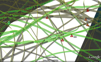
Here’s a very novel approach to the challenge of surveying the nation’s coastal and inland waterways — get the users who ply these waters every day to volunteer to collect the data.
Why is this needed?
According to a white paper recently published by Maryland-based SURVICE Engineering Company who has developed the Autonomous Remote Global Underwater Surveillance (ARGUS) system to provide cooperative surveying of our coastal and inland waterways, The National Oceanic and Atmospheric Administration (NOAA)’s efforts to deliver navigation services are not sufficiently funded to keep pace with US Marine transportation growth. A 2007 report published by the Hydrographic Services Review Panel, the advisory committee established by Congress notes that half the sounding data on NOAA charts was collected before 1940. At the current rate of data collection, NOAA will take 166 years to survey the more than 500,000 square nautical miles of navigationally signficant waters.
How does it work?
The ARGUS system works by recording standard output of off-the-shelf chartplotters routinely used by commercial and recreational vessels and processing the collected information in a very clever way. See the white paper mentioned above for details. Locating areas where actual depths are less than charted depths, the most critical information for mariners will help prioritize detailed surveying and dredging efforts. SURVICE is confident that ARGUS will meet or exceed IHO Order 1 standards in the near future.
Volunteers will have to install a small data collector and connect this device to the onboard navigation system. Readers with boating experience know that BOAT stands for Bring Out Another Thousand –not surprisingly, the data logging units will cost approximately $1000. I was unable to resist volunteering.
SURVICE is leading efforts to get the ARGUS program fully funded. We wish them every success in launching this very fresh approach to an old problem.


.jpg.small.400x400.jpg)
