
Highlights:
- AXIS GeoSpatial LLC offers large-scale survey mapping for highways, college campuses, and more
- AXIS purchased the scanning system for its precision and accuracy
- The sensor will allow AXIS to fly higher, collect data faster, and produce denser point clouds
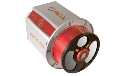
RIEGL USA is pleased to announce that AXIS GeoSpatial LLC, through their purchase and delivery of the LMS-Q1560 dual LiDAR channel airborne laser scanning system, has become the latest U.S. based commercial firm to own this sensor, adding to their LiDAR and camera system fleet!
The RIEGL LMS-Q1560 was selected by AXIS for its remarkable and trusted precision and accuracy, which is unmatched in the industry. The sensor with its rotating mirror design and high output dual laser technology will allow them to deliver higher data density with uniform point distribution and expand the market for LiDAR outside of the conventional large area planning uses. The dual channel scanner utilizes powerful laser sources, multiple-time-around processing, echo digitization which allows for the operation of the system at various flight altitudes and rugged terrain. This new scanner in the AXIS fleet increases their expertise in capturing LiDAR data according to USGS QL2 vertical and horizontal accuracy specifications.
With the addition of the LMS-Q1560 to their fleet, AXIS is empowering their clients with the latest technology to meet their topographic/LiDAR needs, delivering both classified and unclassified Hi-Definition LiDAR datasets to them quickly and efficiently. This cutting-edge system will allow AXIS to fly higher and faster on large scale mapping projects and corridor work, which will provide clients with more dense point clouds, high precision data, faster acquisition, and more responsive service.
“As LiDAR technology continues to evolve, this offering provides our clients with a competitive advantage and another tool in their tool box for meeting and exceeding project time and quality constraints”, says Erica Insley, Marketing Director of AXIS GeoSpatial LLC.
As experts in Hi-Definition LiDAR, AXIS offers survey data for design scale mapping of airports, college campuses, environmental remediation, highways, railroads, pipelines, corridors, and other design and maintenance projects. They pride themselves on their proven track record for effectively managing and delivering large statewide programs with multiple task order deliveries. AXIS has recently acquired and processed over 5,500 square miles of LiDAR for several countywide and statewide projects requiring USGS Quality level 1 and 2 data.


