
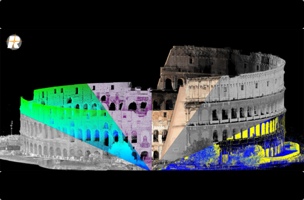
A scan of the Coliseum displayed in RiSCAN PRO, divided by reflectance, amplitude, deviation, true color, multiple echo, and height values.
RIEGL has made a big update to their full suite of terrestrial laser scanning software including RiSCAN PRO, RiMINING, and RiSOLVE.
The update includes a new RIEGL Point Cloud Database (RDB) that offers more advanced point-cloud processing options. For example, the software now enables users to visualize and manage larger files—up to hundreds of scans and billions of points—at a higher level of detail. Users will also be able to toggle quickly between various 3D point attribute view types.
The software’s filtering capabilities have been upgraded to support all point attributes along the processing chain. As RIEGL explains, this means point clouds generated from scans will retain attributes (including reflectance, echo number, and deviation values) through the processing stage.
In a statement, RIEGL hinted that these upgrades will act as groundwork for further workflow improvements in the future–like new export capabilities and additional metadata for pose and geo-referencing.
Along with the new terrestrial laser scanning software, RIEGL is releasing the SDK for their Point Cloud Database to enable third-party development.
“We’re thrilled to introduce this level of computing performance, visualization capability and data storage in a single platform,” said Ananda Fowler, Manager of Terrestrial Laser Scanning Software Development. “With improvements to many aspects of our software; data compression, extended point attributes, level of detail, and a few key innovations which will be revealed in future updates, our point cloud technology has taken a tremendous leap forward.”


