
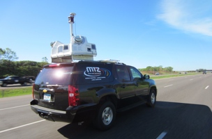
February 25, 2015 — Optech is pleased to announce delivery of an Optech Lynx SG1 Mobile Mapper™ to Martinez Geospatial, Inc. Founded in 1974, Martinez Geospatial has built an industry-wide reputation as an expert in gathering, understanding, and delivering high-quality geospatial data through the use of many different methods, and has now upgraded their abilities with the most accurate and powerful mobile mapper on the market.
The vehicle-mounted Lynx SG1, which creates survey-grade engineering models at highway speeds using its two 360° lidar scanners and high-resolution Ladybug® camera, was delivered to the Martinez Geospatial office in Minneapolis, Minnesota. Optech Services personnel trained the Martinez Geospatial team to operate the Lynx and leverage the advanced rectification algorithms and power of the highly automated Optech LMS Lidar Mapping Suite workflow, maximizing their efficiency and ability to consistently deliver highly accurate data to their clients.
“The Optech Lynx SG1 perfectly complements the other services that Martinez Geospatial offers, so this is a very exciting time for us,” said Steve Martinez, President of Martinez Geospatial. “We have found that the Optech Lynx can easily outperform its listed accuracies, and we feel the benefits of LMS Pro on every project,” added Alan Eisinger, Information Technology Manager at Martinez Geospatial.
“More and more engineering and mapping projects are requiring accurate lidar data these days,” said Albert Iavarone, Business Manager at Optech. “We are happy to enhance Martinez Geospatial’s capabilities in this area with the Lynx system, which will help them efficiently collect dense lidar data for years to come with the support of Optech Services.”
About Martinez Geospatial
Martinez Geospatial, Inc. provides photogrammetry & orthophotography, land surveying, high-definition laser scanning, mobile mapping, spatial modeling, graphics & visualization, and aviation consulting services to public and private clients nationwide. Martinez Geospatial takes tremendous pride in developing innovative geospatial solutions tailored to the unique requirements of each individual project. Working closely with each client, Martinez Geospatial is able to develop a customized plan of appropriate services and products, resulting in a more accurate and timely final deliverable, and better overall customer value.
About Optech
Optech is the world leader in high-accuracy lidar 3D survey systems, integrated cameras, and productivity-enhancing workflows. With operations and staff worldwide, Optech offers both standalone and fully integrated lidar and camera solutions for airborne mapping, airborne lidar bathymetry, mobile mapping, terrestrial laser scanning, mine cavity monitoring, and industrial process control, as well as space-proven sensors. Optech systems are also fully warrantied, with extended warranty packages offered by Optech Services. Accuracy and productivity matter!


.jpg.small.400x400.jpg)