
RIEGL’s new BathyCopter in action
On the first day of Intergeo 2015 in Stuttgart, Germany, RIEGL announced a slate of new products for the professional 3D market. Here’s a rundown.
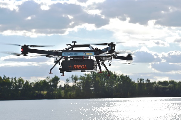
BathyCopter
Following on the heels of last year’s RiCopter, this year RIEGL showcased its new BathyCopter, “a small-UAV-based surveying system capable of measuring through the water surface, ideally suited for generating profiles of waterbodies.”
The BathyCopter is a full integrated solution, including RIEGL’s topo-bathymetric LiDAR sensor, an IMU/GNSS unit with antenna, a control unit, a digital camera, and a data storage unit.
Typical applications include generating river profiles, surveying water reservoirs or canals, landscaping, support of construction projects, and surveys for planning and carrying out hydraulic engineering work.
The BathyCopter is operational at 10-30 meters above the surface of the water and measures down to 1 Secchi depth. It can fly for up to 30 minutes at a time and fits into a case sized at 1,220mm x 810mm x 540mm.
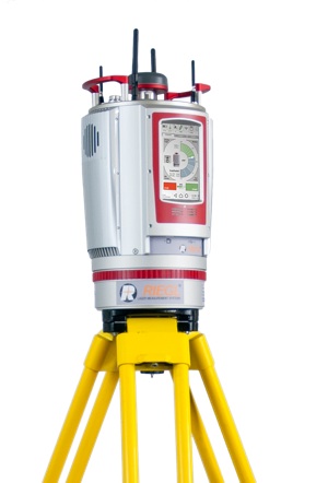 VZ-400i
RIEGL also announced the VZ-400i scanner, which they are calling the evolution of RIEGL’s popular VZ-400 terrestrial scanner.
The specs of the new scanner are a step up from its predecessor, including some notable upgrades for connectivity and ease of use. The VZ-400i scans at a 1.2 MHz repetition rate, works at a range of 800m, and measures at 5mm accuracy.
The scanner includes a new processing architecture that allows it to perform data acquisition, geo-referencing, filtering, and analysis simultaneously in real time. Presumably the “i” in the model name stands for “internet,” since the VZ-400i offers cloud connectivity using Wi-Fi or 4G LTE networks. As a result, raw scan data and processed data can be sent to be cloud storage as the scan is being completed, allowing for easy access later on.
As expected, the system supports peripherals such as cameras and includes a touchscreen for easier operation.
Airborne LiDAR and Software Improvements
RIEGL also announced their new VQ-880-G Topo-Bathymetric LiDAR scanning system, which includes an optional infrared channel to supplement the data acquired by the green laser.
The company introduced new software including RIEGL Database format 2.0, which offers one level of detail, additional point attributes, metadata information, and an SDK for building third-party solutions.
Notably, the company has “streamlined” the algorithms in RiWORLD 5.0, which allows for a 60% increase in processing speed, and when used in combination with the new RiProcess, improved performance of up to 300%.
For more information about RIEGL’s slate of new products, stay tuned to SPAR in the coming weeks.


