

3D Laser Mapping has announced the StreetMapperIV mobile mapping system at Intergeo2015. They are touting it as the next generation version of the StreetMapper, which was originally released in 2004 and saw alternate versions developed in 2010 and 2012.
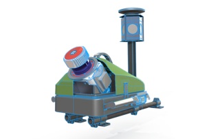
The StreetMapperIV comprises a differential GNSS and IMU components (combined in the “TERRAcontrol” system), a small data-logging PC, and a roof-mounted laser (from the shots, the laser appears to be a RIEGL VUX-1). It is accurate up to 10mm and runs off of a vehicle battery, or even a small, standalone 12V.
As 3D Laser Mapping’s Global Sales and Marketing Manager Charlie Whyman told SPAR, this new StreetMapper sees accuracy gains over previous systems, but that was not the company’s primary goal. Instead, they aimed to make a mobile mapping system that was more competitively priced, but also lighter, smaller, more flexible, and easier to use. In other words, this design is meant to make the StreetMapper as affordable and user friendly as possible.
To that end, she explained that the weight and size of the StreetMapper have shrunk enough that the whole system can easily be mounted by one person. “It’s a lot smaller than you think,” Whyman said, “it’s 240cm long and 60cm wide. I can pick it up with one arm.”
This minimal profile gives the StreetMapperIV other advantages, like a highly simplified transportation and setup process. “A lot of our customers were telling us that they wanted something that was highly portable,” Whyman told SPAR, “so they could ship it around the world easily, take it out of the box and then mount it on a car or a buggy, or whatever vehicle. They wanted to start scanning without having a big team of people on-site ready to install it.”
The StreetMapperIV was also designed to be a lot more flexible than their previous systems.
For one, the smaller size means it can be mounted in a larger variety of situations. “You can mount it on any vehicle,” Whyman said. “You can use it on rails, on a boat, we have customers who mount it on a buggy to drive it around their mines.”
Second, the StreetMapperIV increases flexibility by allowing a number of different configurations depending on the intended use. “If you have a laser scanner sensor, you can have a single or dual scanner system,” said Whyman. “You can choose between two different types of IMU, depending on how much accuracy you want.”
Maybe most importantly, 3D Laser Mapping has put a lot of work into making sure that the system can be used by just about anybody. “We’ve simplified the design massively, so it doesn’t take a really experienced operator to use it. It connects via one cable, and it’s on-click operation via touch screen.”
“It’s very easy to use,” she said. “Anybody can use it.”


