
Coalville, Leicestershire, UK, 21 January 2015 — Bluesky International Limited, a specialist in aerial survey, has launched the prototype of a website that uses geographic data, including 3D imaging data, to help users across Europe determine the suitability of a property for solar energy.
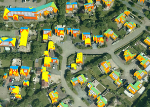
Officially named the EAGLE platform, the website is the second and final stage of a €2.4 million EU project designed to help Europe meet ambitious renewable energy goals. The first stage was the collection and exploitation of geographic data, such as aerial photography and LiDAR to assess the suitability of specific properties. On the EAGLE platform, this information will be combined with address records, details of energy tariffs, expected consumption, cost of installation, and available subsidies to help users determine the potential ROI for solar energy systems.
Bluesky provided the technical lead for the full project.
The prototype demonstrates the platform’s interface but is not yet populated with the collected data. Click here to see the prototype: www.eaglesolar.eu
“The EAGLE Platform is different,” said James Eddy, Technical Coordinator for the Eagle Project and Director of Bluesky. “Underpinned by a wide spectrum of geographic information, including 3D imaging such as LiDAR as well as more traditional aerial photographs, address and cadastre data, it is more accurate, reliable and objective than other systems coming to market.”
Though the initial aim of the project has been solar power generation, there are plans to accommodate other types of renewable energy like, wind, hydro, and ground source heat. Eagleview is motivated to expand the project in order to enhance its own position at the forefront of this emerging technology.
Bluesky has previously worked with other large organizations such as Google, the BBC, and varying government agencies. They also have deep experience with mapping solutions for environmental problems, including the Uk’s first national tree map, citywide ‘heat loss’ maps, and forthcoming noise and air quality maps.


