
“LiDAR is of the highest priority and will bring the highest environmental benefits.”
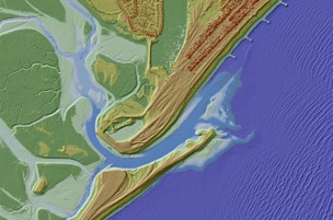
The UK Environmental Agency has been capturing LiDAR data for more than 17 years. In that time, they’ve captured more than 72% of England’s land mass, including flood plains, coastal zones, and urban areas. That LiDAR data has helped the Environmental Agency to create flood models, assess coastal change, and examine how land is used.
Two years ago, the agency made the tiled LiDAR data and the composite LiDAR data in their collection available for non-commercial use. Starting September 2015, they will make that same data available to everyone–commercial or not.
When I spoke to Susan Winter, the marketing officer for the Environmental Agency, she explained why the agency decided to open the data up for commercial use.
“Following the floods of 2014,” she said, “the Environmental Agency made a decision to look at all the data sets and work out the feasibility of making them open. So they set up a data advisory group, which consists of members of the Environmental Agency and lots of other interested parties from government and other organizations and they have been looking at the issue of open data for the last year.”
There are other data sets held by the agency, but they are releasing the LiDAR set first because, according to Winter, it is “one of the data sets that was considered to be of the highest priority and will bring the highest environmental benefit.”
She explained that the highest priority is the environment. But what might commercial entities do with the data that could help the environment?
In a blog post from the Environmental Agency, they argue that it could provide businesses the opportunity to improve the quality of flood risk modeling, and for developers to create “innovative new tools and techniques to further benefit the environment.” For instance, how about an easy flood modeling app?
“There’s been quite an active open data section in the UK,” Winter told me. “A lot of people have been calling for more data sets to be open, and there was certain a number of people that was pushing for the LiDAR set to be more open.”
The agency holds a huge repository of many different kinds of data–one blog post puts the number at 101–all of which might be of use to different businesses and members of the public once they’re released. Though the agency has trouble knowing what might be of use to the public, organizations, and businesses, the advisory group Winter mentioned is continuing to review the data and help decide what datasets to release next.
And it’s hard to know exactly what will come of the data once it’s released into the wild.


